
GEOLOGY OF WEST DUNBARTONSHIRE
The very name conjours up the geology and geography of the area. And the peoples who settled here.
Dun is an ancient or medieval fortified hill. The term comes from Irish dún or Scottish Gaelic dùn (meaning "fort"), and is cognate with Old Welsh din (whence Welsh dinas "city" comes).
And Barton refers to the ancient Brythonic tribes who migrated here, subsequently linking their name with that of the hill. And so we have the hillfort of the Britons. "Dun" morphed into "Dum" for the town, but remains as "Dun" for the county of Dunbartonshire - now one of two regional administrative areas West and East.
What better way to introduce the geology of West Dunbartonshire. This is a layman's view. A deep scientific assessment is far more complex.
We may not be right at the foothills of the dramatic Highlands, but we are literally between the mighty Clyde and the Highland Boundary Fault.
InfoScot puts it very well : Scotland's geological history is multifaceted, extending over three billion years, encompassing shifts from being part of vast continents to isolated islands. Initially, during the Precambrian era, it was part of a landmass near the South Pole, harboring some of the oldest rocks on Earth, visible today in the Northwest Highlands. Scotland then became part of the supercontinent Laurentia, and later collided with what is now England and Wales, forming the supercontinent Pangaea in the late Paleozoic era, causing the creation of the Caledonian Mountain range. The subsequent breakup of Pangaea led to various geological transformations, including volcanic activity and glaciation during the Quaternary period, which shaped Scotland's valleys, lochs, and rugged landscapes. Additionally, it underwent significant sedimentation processes, which have yielded extensive coal, oil and gas deposits. [InfoScot].
VOLCANIC PLUGS
In the Early Carboniferous period, about 330-340 million years ago, there was widespread volcanic activity in the area central west of what is now Scotland, roughly west of Glasgow. Evidence of this can still be seen today in the lavas of the Kilpatrick Hills, Campsie Fells and Renfrewshire Heights. One of the volcanoes which poured out lava was at Dumbarton Rock. Today, all that remains is the basalt plug at the root of the long-extinct volcano. [Strathclyde Geoconservation Group]. See : DUMBARTON CASTLE AND ROCK
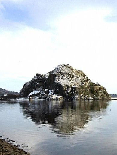
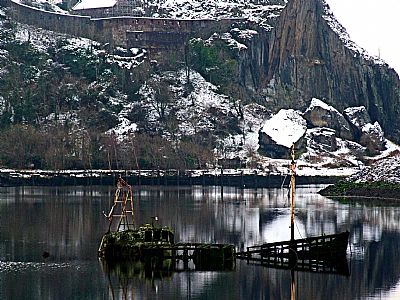
Dumbarton Rock as seen from the west across the Leven where it joins the Clyde.
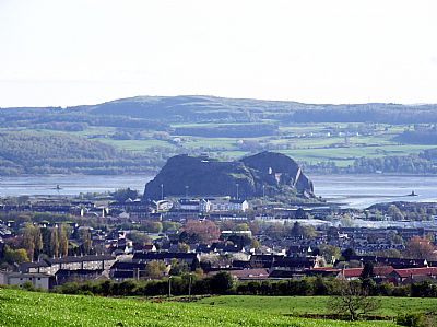
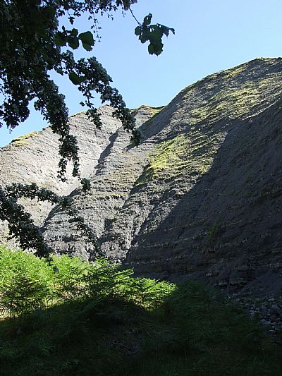
This view from the Lang Craigs clearly shows the split nature of Dumbarton Rock.
Other outcrops seem to be of similar origin. One is that which Dunglass Castle sits on. As with Dumbarton Rock, it protrudes into the Clyde forming an obvious places to build a strategic defensive structure.
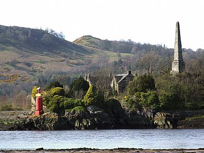
Dunglass Castle with its beacon and Bell Memorial. The mansion can be seen behind it. DUNGLASS CASTLE, NEAR BOWLING
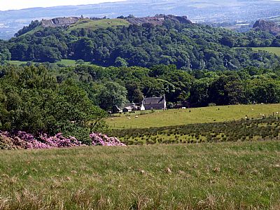
Hills formed from volcanic plugs abound in Scotland; from Edinburgh's Castle Rock to Aisla Craig, so our Dumbarton Rock fits into a rich geological pattern. Another one within West Dunbartonshire is Duncryne near Gartocharn. See : DUNCRYNE HILL, NEAR GARTOCHARN
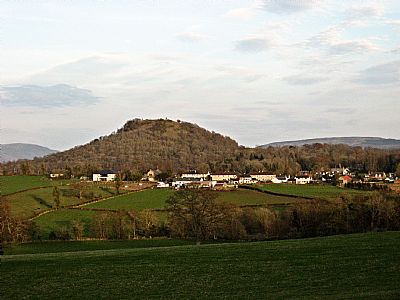
Duncryne Hill near Gartocharn.
Again refering to the Strathclyde Geoconservation Group we learn that : About 10,000 years ago vast sheets of ice covered an area of Scotland as far south as the Loch Lomond area. As the temperature warmed the ice melted rapidly, in terms of geological time, causing the land to readjust to the loss of weight of the ice; it did so by fault movement causing earthquakes. These earthquakes caused the huge basalt blocks to break off from the main park of the Rock leaving a sheer face and the blocks strewn below.
Those boulders that have broken off from the main rock face are very evident in this photo taken in winter. They are a popular as a training location for bouldering enthusiasts.
These descriptions are naturally basic. If you wish to have a more scientific analysis, you need to look elsewhere. (Some references are given below). Dumbarton Rock is composed of alkali olivine basalt and has close petrographical and geochemical affinities with the Visean volcanic rocks of the Clyde Plateau Volcanic Formation in the adjacent Kilpatrick Hills. [J.G. MacDonald - Geo-Guide : Scottish Geology Trust].
THE KILPATRICK HILLS AND THE LANGCRAIGS
Also see : LANG CRAIGS

The Lang Craigs form the western edge of the Kilpatrick Hills and overlook Dumbarton and this end of the Vale of Leven.

Here we see the Langcraigs. The strange dots across the hill in the foreground are holes for new trees.
Once you are up the Kilpatrick Hills, you may want to head to one or more of the lochs. These are man-made, but making the most of natural depressions in the rolling landscape. On the other hand you can head to the highest point, Duncolm, crossing the lower Slacks on the way. There are actually two hillocks, the highest being 401 metres (1,316 ft). Its name means "Fort of Columba". [Wiki].
Also see : WALKS IN WEST DUNBARTONSHIRE
THE RIVER CLYDE
As look down from the Kilpatrick Hills, there below you flows the Clyde heading westwards into the Firth of Clyde and thence into the Atlantic.

In this photo taken from the Erskine Bridge we see the Clyde with Dumbarton Rock in the distance.
As you enjoy this view, consider why the landscape south of you looks so different to that northwards. While the Highlands of of Scotland start (arguably) from a point in line with Ben Lomond, not here, there is nevertheless an evident difference between north / northwest and south. West Dunbartonshire appears to be an edge between two landscapes. Seeing it in this light makes it extremely interesting in geological terms.
RAISED BEACHES AND THE COASTAL CRAIGS.
Dumbarton shares a coastal geological feature with places such as the Ayrshire coast in raised beaches. These were by post-glacial sea level changes which occurred as the land, released from the weight of ice sheets, rose relative to the sea. This landscape type occurs where areas of higher ground reach the coast and where the raised beach is visible as a level platform backed by a steep escarpment. The latter represents the former cliff-line. Thus, although termed 'raised beach', this landscape type actually comprises the former beach platform, the cliff and areas above. [NatureScot].
You begin to see these clearly when walking from Levengrove Park westwards. A cliff face stretches from here all the way to Cardross with Craigend plant nursery and the nearby farm of the same name recognising this feature. Havoc Hole is one of the larger vertical fissures that have become eroded into the rock face and has subsequently become imbued with legend. See HAVOC HOLE, HAVOC ROAD, DUMBARTON

The rock face adjoining Havoc Hole with the raised beach between it and the Clyde to the left.
So you now have a picture of dramatic creation and deposit recreated through erostion. At the foothills of the Langcraigs is an excellent exposure of this geology - MURROCH BURN.
EROSION & EXPOSURE
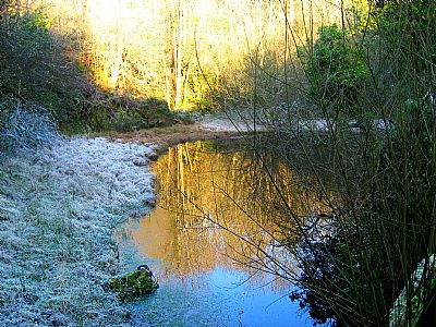
Murroch Burn east of Nobleston is of moderate slize, yet it flows through a dramatic landscape. Fully exploring it requires some scrambling - and we must note - great caution. However the lower end is fairly easy to access through the woods. Upstream from this point it becomes somewhat perilous due to the crumbling nature of the steep deep gorge.
In spite of most of this gorge being formed of Calcilutite (also known as cementstone), strata of harder material can be seen. At one point a vertical dyke is clearly seen.
The Murroch Burn gauges its way throuogh deep layers of soft rock.
So soft and friable that it crumbling before our eyes. Yet layers of harder material are seen too.
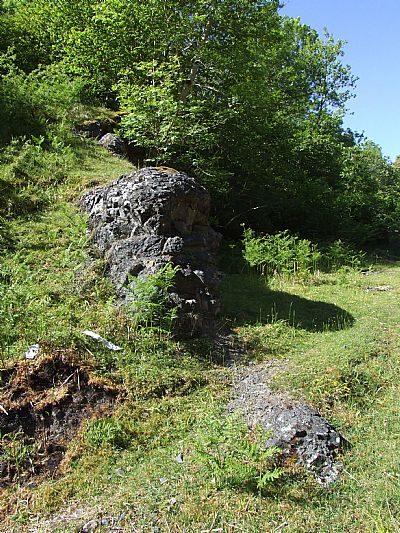
At this point we find what looks like a man-made wall, but which is a vertical dyke of harder material.
QUARRIES
If we include the small quarries opened up to contribute to the aggregate and fill for construction, we can find several.
Sheephill Quarry operated by William Thompson and Son and provides a great deal of material used around West Dunbartonshire and beyond.
Dumbuck Hill Quarry operated by Patersons.
Dumbuck Quarry adjacent Dumbowie. (2010).
These two quarries are the largest by far in West Dunbartonshire and are located on high rock outcrops on each side of Milton. They are both active basalt quarries with locally visible columnar jointing and the remnants of volcanic plugs. Naturally these were at a time in ancient history, also sought after "duns" in other words strategic defensive positions overlooking the Clyde.
See : SHEEP HILL FORT, AUCHENTORLIE
and
Other smaller quarries can be found at (amongst others):
The quarry known as "Black Castle" has long since filled with water.
DUNCRYNE HILL, NEAR GARTOCHARN
FAERIE KNOWE - CARMAN QUARRY, CARMAN HILL
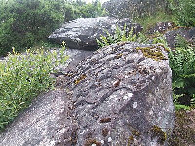
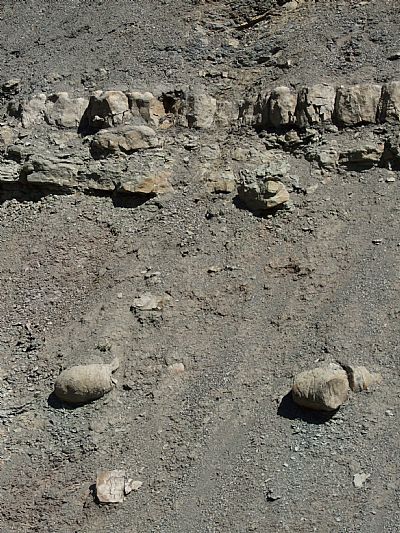
The quarry at "Faerie Knowe" on Carman Muir has long been out of use. Many large slabs remain upended, presumably considered unsuitable. But several have these intruiguing inverted mud crack imprint "fossils".
THE HIGHLAND BOUNDARY FAULT LINE
To the north of West Dunbartonshire and in some ways defining that edge with Argyll and Bute to the west and East Dunbartonshire to the east, is the Highland Boundary Fault Line. Very soon after crossing this line, you find yourself getting into the mountains of the Highlands.
The Highland Boundary Fault is a geological fault line that runs across Scotland from Arran in the west to Stonehaven in the east, traversing the southern edge of the Cateran Ecomuseum. ...
The Boundary Fault’s heyday was around 400 million years ago, during collisions of ancient continents. This was a time when both the mountains in much of the Highlands rose and the Central Lowlands sank, forming a huge valley across the middle of the Scottish mainland....
The Highland Boundary Fault remains not only the most important geological division in Scotland but for a long time from the late middle ages, it was a great cultural boundary as well because it determined how people settled the land and what they could do with it.
The hard rocks north of the fault line made it difficult to grow crops, whereas the softer sandstone south of fault line created some of the most fertile soils in Scotland supporting a wide range of agricultural activities. The different way the land was able to be used meant that in those times people structured their society differently too. [Cateran Ecomuseum].
This is an interesting point and shows how we are entertwined with the geology we live on and amongst.
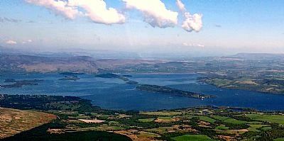
The fault line across Loch Lomond is clearly seen in this photo taken from the sea plane. It forms a very linear arrangement in the islands (as compared to the others to the north). Conic Hill and Stirlingshire appear in the distance / east; West Dunbartonshire to the right / south and Argyll and Bute below / west. The Highlands start to the north of here (to the left).
DEPOSITS
In the discussion to far we have seen how the landscape has formed through collision and erosion leading to layers of different rock types and soils.
There is one more local feature to point out. The deposit of organic material and its subsequent quarrying. Limestone aTrnd coal.
Coal
There are no known deposits of coal within West Dunbartonshire. - Or are there? There are anecdotal records of it and these are rather thin. William Dunn, who was born in Kirkintilloch in 1770, trained as a cotton spinner in Glasgow and then spent four years learning iron-turning and machine making. In 1808 he bought the Duntocher Mill and over the next 23 years he acquired Faifley Mill, the Dalnotter Iron Works and built Hardgate Mill. He came to own much of the surrounding land and eventually employed nearly 2000 people in cotton manufacture, agriculture and mining. [David Carson]. He is said to have had a colliery. However that could mean a coal yard rather than a mine.
But we then find this reference dated 15 May 1858.
Fearful Colliery Explosion – Four Lives lost - On Saturday morning early a fearful explosion of fire damp took place in Mr Dunn's Colliery, near Duntocher. Up till Monday afternoon three of the bodies had been recovered; great exertions are being made to reach the place where it is supposed the fourth body will be found. The explosion must have been very violent. One of the bodies was fearfully burned, no trace of clothing could be found on it. Hutches, &c., were driven in one mass to the bottom of shaft, and one of the boxes was blown right up the shaft a distance of nearly 100 fathoms. The Procurator Fiscal has visited the colliery. Mr Alexander, Government Inspector of Mines, and the manager have had a consultation; they afterwards descended the shaft and examined the works. In exploring, great care and caution is required, as the fire damp still lurks in the openings, and is only forced out as the airways advance. [Hamilton Advertiser May 22 1858 as noted on the Scottish Mining website.]
One imagines that if the mine(s) existed and were viable, there would have been more than just exploratory shafts.
We next hear of some substantial evidence in this newspaper article from the Clydebank Post.
‘Collapsed mine’ forces residents out.
The Coal Authority was called in after properties in Briar Drive, Parkhall, started showing signs of damage due to sinking.
The area at the back of the properties has been fenced off and the situation has been deemed so dangerous, residents have been advised not to stay there.
Other people living in the area are now nervous that their homes could be affected. [Clydebank Post].
And then we see this, again from the Clydebank Post, this time of 27th January 2017:
"Kilbowie Road sinkhole is 62 metres deep and caused by historic mines, say council".
West Dunbartonshire Council called in The Coal Authority after specialist engineers drafted in to investigate the issue in Kilbowie Road uncovered a 6 metre deep cavity lying underground on top of a 56 metre deep shaft - meaning the shaft, which measured 3.5 metres by 2 metres, dropped to a staggering depth of 62 metres from the road.
The Coal Authority has been carrying out detailed assessments at the site between Kilbowie and Hardgate roundabouts over the last two weeks.
Their investigation has identified that the void is due to historic coal workings at this location As a result the government body is taking responsibility for the reinstatement of the site and all associated works, and has now commenced the operation. [Clydebank Post].
Lime
Limestone shares its origins with coal in that it is derived from deposits of organic matter. Limestone is sedimentary rock composed mainly of calcium carbonate (CaCO3), usually in the form of calcite or aragonite. It may contain considerable amounts of magnesium carbonate (dolomite) as well; minor constituents also commonly present include clay, iron carbonate, feldspar, pyrite, and quartz. [Britannica].
West Dunbartonshire does not have limestone in its more well known white form which is easier to process. But it does have cornstone, a mottled red and green limestone characteristic of the Old and the New Red Sandstone.
Cornstone is a sandstone containing calcareous concretions, very characteristic of some of the older Red Sandstone formations.
All of these commercial establishments in the central belt were sited on the main seams of Carboniferous limestone underlain by coal. Before the advent of crushing machines, burning the quarried limestone with coal in special kilns and then slaking the resultant calcined lime (quicklime) with water was the only practicable method available for reducing the hard rock into a soluble powder. ...
The derivation of the term cornstone is obscure. Its use as a fertiliser in the cultivation of cereal crops might seem the most obvious explanation, but it is equally likely that the name comes from cornstone’s granular texture (Arkell & Tomkeieff, 1953). Atypical in being a terrestrial rather than a marine limestone, comstones are fossil soils formed under semi-arid conditions. During periods of sustained drought lime-rich water is drawn up by capillary action to the land surface, where the calcium carbonate is precipitated in the sub-soil by evaporation. [John Mitchell]
There is a worked outcrop on Carman Muir where tailings remain of the rock excavated, but not removed. Unfortunately forestry planting and a fence now curtail access, but you can see more about it here: CORNSTONE WORKINGS, CARMAN MUIR

Here we see the tailings, the excavated material ready to be carted away, but never were.
Lairig Rigg notes another workings - The tracks branch off from two main routes: the Common Drove Road, which runs eastwards from Bonhill to the Common Ford and beyond; and the Old Drymen Road, which runs NNE, from Dumbarton to Drymen.
CLYDEBANK HISTORY SOCIETY : https://clydebankhistory.org/conc/index.php/clydebank-history/neighbourhoods/duntocher/
CLYDEBANK POST : https://www.clydebankpost.co.uk/news/13937269.collapsed-mine-forces-residents-out/
DUMBARTON CASTLE SOCIETY :https://www.dumbartoncastle.co.uk/geology
GEOLOGICAL FEATURES OF DUMBARTON ROCK - Strathclyde Geoconservation Group: https://geologyglasgow.org.uk/docs/017__074__publications__Final_Printers_Dumbarton_Rock_Leaflet__1329125115.pdf
GEOLOGICAL SOCIETY OF GLASGOW :https://geologyglasgow.org.uk/sites/duncryne-hill/
INFO SCOT website: https://info.scot/library/history/events/geological-history?timeline=historic
LAIRIG RIGG - Geograph. https://www.geograph.org.uk/article/West-Dunbartonshire-Limestone-Industry-Network
MACDONALD, J. G. - GEOGUIDE OF THE SCOTTISH GEOLOGY TRUST : https://geoguide.scottishgeologytrust.org/p/gcr/gcr27/gcr27_dumbartonrock
MITCHELL, JOHN : Old Cornstone Workings in Dunbartonshire and
West Stirlingshire, with Notes on their Associated Flora.
MINDAT : https://www.mindat.org/loc-450907.html
& https://www.mindat.org/loc-450910.html
NATURE SCOT : https://ia801501.us.archive.org/27/items/biostor-224899/biostor-224899.pdf
SCOTTISH MINING : http://www.scottishmining.co.uk/324.html
WALK HIGHLANDS : https://www.walkhighlands.co.uk/glasgow/duncolm.shtml
WIKIPEDIA : https://commons.wikimedia.org/wiki/Category:Geology_of_West_Dunbartonshire
