MILTON
This place name is often found as it is quite literally, a town, or at least a cluster of buildings centred on a mill. This one is no exception. Joseph Irving writing in 1879 describes a Milton that is unrecognisable except for the origin of the name. At Milton, a manufactory was established nearly a century ago for bleaching and calico printing. More recently weaving was added to those branches of trade; and it is worthy of notice, that the first factory for weaving cloth by power other than the hand was erected here, and continued in operation for many years. One of the original looms was preserved as a momento till 1850, when it was unfortunately destroyed by a fire whuch consumed the building in which it stood. In 1817, the late Mr. Patrick Mitchell purchased the works, mansion-house, and adjoining grounds, from D. Hort M'Dowall, and greatly improved the property, by consolidatating into one establishment the different branches of trade formerly carried out in separate works and by different companies. For about thirty years Mr. Mitchell continued to employ an average of over 300 hands at Milton; but soon after his death, in 1848, his nephews and successors, Messrs. Muter & Miller, introduced machinery into the works, which somewhat lessened the number employed, but greatly increased the production. Of late years Milton works have been thoroughly remodelled, improved, and fitted up with the most improved machinery for the manufacture of paper, now turned out in large quantities by the tenants, Messrs. R. Biggart & Co. Milton House continues to be the residence of Andrew Muter, Esq. The adjacent village has much improved of late years, by the erection of new dwellings, and also of a commoddious school-house, with teacher's residence. [Irving].
There are several interesting buildings of note. Milton House for example is associated with the textile mill. ilton House is an elegant, two storey pedimented mansion built in 1792.
Canmore intrigingly notes that Middleton Farm steading further north was built on the ruins of an earlier mansion or castle. The Lorans family were tenants of Middleton Farm for several centuries... circa 1810s a part of the wall still stood on the NE side of the present farm-house and was over 3 feet thick and stood about 7-8 feet high...[Canmore].
Not that far from that and on a bend in the Milton Burn were the ruins of the Old Chapel of Colquhoun. Canmore quoting J.Bruce notes that to the north-west of the old castle ... and below the Muir of Colquhoun is a knoll or mound called Chapel Knowe. In the centre of this knoll there is the appearance of the foundations of a small building, and the state of the surrounding ground indicates that in early times it had been used as a place of sepulture. A tradition is preserved among the old people that on this knoll a chapel formerly stood and it is said that part of the walls about 100 years ago remained. Within this century, tombstones have been excavated from the ground on the Chapel Knowe." [Canmore].
It is interesting to ponder the area in an earlier era with castle or grand mansion and the nearby chapel. We only have these scant clues that they existed at all.
That school was closed in 2004 and it became a childcare centre. [Wiki]. MILTON PRIMARY SCHOOL
The village can also claim that it was the home of the racing driver Jackie Stewart, whose family ran the Dumbuck Garage. Captain Ian Patrick Robert Napier MC, also came from there (24 June 1895 – 9 May 1977). He was a Scottish World War I flying ace credited with twelve aerial victories. [Wiki].

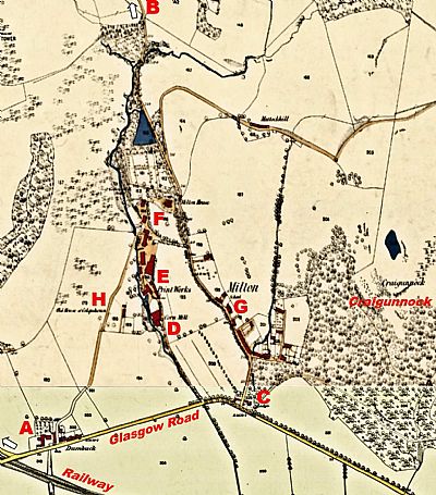
This is a composite of two maps dated 1860. A = Dumbuck. not the hotel, but the home farms noted by Irving (see DUMBUCK HOUSE HOTEL, Glasgow Road); B = Overtoun House, further along that road northwards and out of sight here; C = Lodge, ie that of Overtoun House down on the main road to Glasgow. This is where we turn up to reach Overtoun House today. The lodge was demolished by the shed company when they took over that site; D = the Corn Mill which gave the area its name; E = the print works; G = the old school; H = "old house of Colquhurn" (This appears to indicate the site of this house, but then already gone).
This section of Glasgow Road is now the A82. You can see it branching off to the northwest as shown by the arrow. At that point it becomes Stirling Road. The current roads still meet at this point and cross the "railway" over the bridge - but this railway line is now the cycle path, the current railway line being closer to the Clyde to the south. The mill would have been driven by the water from the Milton Burn. You can also see a reservoir up from the print works created to ensure a constant flow. Some vestiges of the Dumbuck Farm buildings appear to survive in the much altered and extended Filshies Fabrications and the Milton Inn, currently Lochway Hotel. The old road up from this point is no longer accessible, but can still be recognised up behind that.
CANMORE : https://canmore.org.uk/collection/2425949
and https://canmore.org.uk/collection/2425946
IRVING, JOSEPH. The Book of Dumbartonshire. W. and A.K.Johnstone. Edinburgh and London. 1879.
NATIONAL LIBRARY OF SCOTLAND : MAPS : Dumbartonshire XXII.7 (Old Kilpatrick). Survey date: 1860 to 1861, Publication date: 1862 https://maps.nls.uk/view/74941979; and Dumbartonshire XXII.11 (Combined). Survey date: 1861, Publication date: 1884. https://maps.nls.uk/view/74478218
WIKIPEDIA : https://en.wikipedia.org/wiki/Milton,_West_Dunbartonshire

