
ANTONINE WALL : OLD KILPATRICK FORT, Old Kilpatrick.
ACCESS : The site is now hidden and confused by later developments, but that near the Forth and Clyde Canal is readily accessible and pleasant to visit.
Scheduled Monument and World Heritage Site.
///civic.landed.tolerable This is the warehouse gate on Dumbarton Road ( near Gavinburn School). No access.
///hazy.strange.furniture This is the bascule bridge crossing of the canal off Port Patrick Road, Ferrydyke. From here you can walk to the Clyde shore.
Some sort of fort existed here before the Antonine Wall linked it with others across the central Scotland isthmus. Depending on your point of view, the Wall terminated or started here in the west at what we now call Old Kilpatrick.
The site of the fort is extensive and lies under the present warehousing (previously a bus depot). PastMap (see link below) is a good way to appreciate the Wall and Fort at this point. Zoom in a turn on the data layers for "Canmore" and "Scheduled Monuments".
You will see that the Wall passes through the north and west of the large fort. From there it went to the shores of the Clyde. There is likely to have been some sort of moorings here, but there is no sign of that. Then it marches off in a north easterly direction.
Excavations were carried out in 1923-24 and further work was carried out by trenching in 1931, indicated that there was a fort on this site before the wall was built. Archaeological investigations have shown that within the fort were the remains of the headquarters building and a granary, both built of stone, and three wooden buildings which may have been stores, workshops and barn; a latrine was situated in the south corner of the fort.
Distance slabs and altars have been found here and in the vicinity and can now been seen in the Hunterian Museum at the University of Glasgow. These are described in the Heritage Trail publication.
During the consultations on the run up to the bid to get the Antonine Wall designated a World Heritage Site, some local residents recalled seeing artefacts dug up in their gardens years before. It is usually thought that the fort extended approximately to that of the current warehousing complex. But it extended far beyond that. A planning applicant in the area in 2024 was startled to find a requirement for a watching brief for a registered archaeologist.
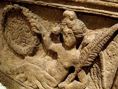
Detail of the distance slab commemorating the 4411 feet (in today's units) completed by the Twentieth Legion. This is on display in the Hunterian Museum at Glasgow University.
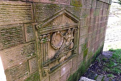
A replica of this stone has been incorporated into this feature at the bascule bridge on the canal. The Wall originally reached across where the canal was later built. Depending on your point of view the Wall starts or terminates here.
This is the reverse of this feature and has very interesting information on it.
HERITAGE DAILY : https://www.heritagedaily.com/2021/01/vallum-antonini-the-antonine-wall/136706 This has a useful map and aerial photos.
PASTMAP : https://www.pastmap.org.uk/map
WEST DUNBARTONSHIRE HERITAGE TRAIL : ANTONINE WALL : https://www.west-dunbarton.gov.uk/media/2619055/antonine.pdf
WEST DUNBARTONSHIRE HERITAGE TRAIL : OLD KILPATRICK, BOWLING AND MILTON : https://www.west-dunbarton.gov.uk/media/2619074/ok_booklet.pdf
