
BOWLING HARBOUR, Main Harbour, Bowling
ACCESS : This can be approached from the river side of Bowling Station. However it is not entirely safe. It should rather be viewed from the canal basin or the footbridge over Bowling Station.
///approvals.dampen.riverboat The best viewpoint is from the canal basin.
///vandalism.apple.chairing This is the crossing point over the railway footbridge and provides ample views of the harbour.
NOTE : This harbour used to serve sea going vessels on the Clyde. It was complementary to the Forth and Clyde Canal. While some maps refer to the basin of the canal just above this harbour as "Bowling Harbour", it is now usual to refer to the basin as Bowling Harbour rather than this one. In a way they are each parts of the same harbour complex.
Visit this harbour at high tide and you would think it just another small harbour although you will soon notice a number of partially sunken vessels poking their superstructure forlornly out of the water. Visit it at low tide and the scene is even more forlorn. A vast sticky expanse of mud greets you. And those vessels can be seen at odd angles in that mud - picturesque though in a strange way. Do not attempt to approach them. That mud sucks you in. It is a sad scene, but the commercial potential of reclaiming the harbour is simply currently not viable.
The stone wall that is meant to protect the harbour from heavy weather and extreme current down the Clyde, is now partially collapsed; the once neat stone inner lining no longer serving its purpose. But in spite of that a modern navigation light comprising a thin steel pole and supporting an electric lamp stands on the far end.
Maps of 1918 and 1939 indicate a flagstaff at this location which appears to have stood on a large square plinth that is still visible.
Canmore tells us that this was used mainly for the laying up of vessels for repairs at Scott's shipyard and of pleasure steamers during the winter. This is illustrated on their website by old photos showing several sailing vessels or paddlesteamers (depending on the period), some utilising the quayside, others appearing to be moored in groups.
Plans have been mooted to use the currently derelict land on this side of the railway and slightly downstream, for housing. While the practicalities have not all been resolved (eg getting over the railway), this raises the prospects of improving this whole area, perhaps one day enabling the harbour to be viably reinstated too.
There are also the remains of some heavy timber decking that once formed a quay alongside a slipway. This cannot be safely approached. For more on that and beyond it refer to BOWLING SHIPYARD.
While this all looks rather despondent today, in the past this was a vibrant small harbour with a protective outer wall against the flow of the Clyde, a slipway and timber quayside with an area to one side for smaller craft.
Let's end at the beginning with a quote from John Bruce's book written in 1893 (see reference below); The village of Bowling, or, as it was known many years ago, Bowling Bay, appears in the parish registers as the Bowland of Spittal, evidently deriving its appellation from the curve of the bay which has been greatly and repeatedly altered since the formation of the Canal in 1790 down to the present day. The present harbour and canal basin was constructed by the Canal Company in the year 1850, and a considerable extension of the canal basin is now in progress subsequent on the alterations considered necessary by the new railway. The western portion of the harbour belonging to the Clyde Trustees was constructed in the year 1840, and altered as it now appears in 1857, after the great gale in February of that year.
When the Canal was completed a graving dock was constructed suitable for the repair of vessels passing through the Navigation. In the year 1800 this dock was let to Thomas Macgill, who is styled in the lease as shipbuilder, Broomielaw, where he had built the now almost extinct craft known as "gabberts", and repaired the Highland wherries which in those days formed th bulk of the shipping in the harbour of Glasgow.
The size and type of ships built progressed with the first schooner built on the Clyde, the "Osprey" being launched here. In his book, John Bruce tells us that she was owned by Captain Walter Scott. Her design was based on another ship, the "Glasgow", which had been overhauled here. In 1812 the sloop "Acorn", latterly masted as a schooner, was launched, and was partly built from the wood of the old parish church.
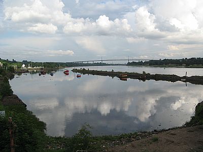
Looking the full length of the main basin towards the canal basin at the higher level and towards the Erskine Bridge in the distance.
The west wall is of stone, some parts of which are crumbling. The east wall has timber support which has deteriorated even more.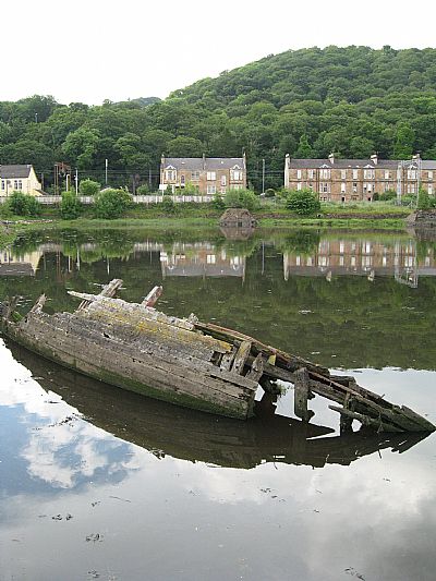
The remains of old boats emerge from the water with the tides.
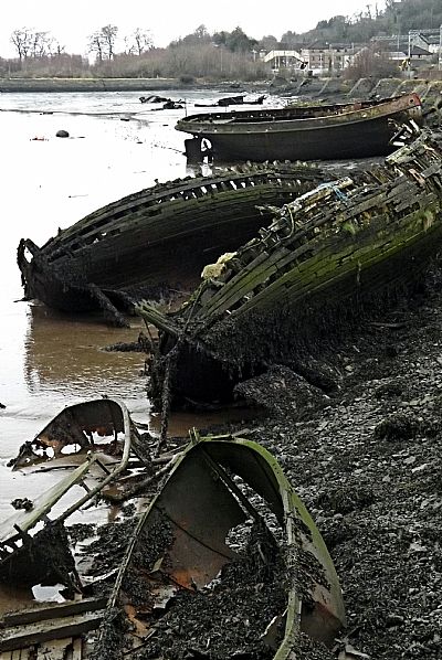
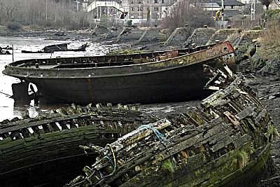
As the tide recedes the scene becomes a little sinister, yet captivating.
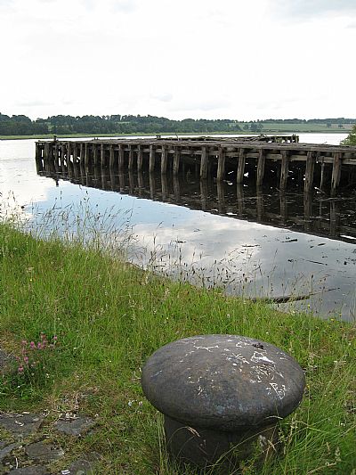
The old wooden quay and slipway to the right. For more on that see BOWLING SHIPYARD
BRUCE, JOHN, History of the Parish of West or Old Kilpatrick and of the Church and certain lands in the Parish of East or New Kilpatrick. 1893. Republished by the Clydebank District Libaries and Museums Department, 1995. ISBN096938112. (Reference above p 186).
CANMORE : https://canmore.org.uk/collection/1246257; https://canmore.org.uk/site/43393/forth-and-clyde-canal-bowling-harbour
SCOTTISH CANALS website : https://www.scottishcanals.co.uk/destinations/bowling-harbour/
WEST DUNBARTONSHIRE HERITAGE TRAIL : OLD KILPATRICK, BOWLING AND MILTON : https://www.west-dunbarton.gov.uk/media/2619074/ok_booklet.pdf
