
OLD KILPATRICK
Considering its modest size, Old Kilpatrick village is rich in history. The village character is somewhat overshadowed (literally) today by the Erskine Bridge, but it remains a place well worth visiting. The Forth and Clyde Canal FORTH AND CLYDE CANAL passes through it on its way to nearby Bowling to the west with Dalmuir to the east. Its most important historical claim though is that it was the western-most end of the Antonine Wall and had a large Roman Fort. See ANTONINE WALL : OLD KILPATRICK Along with that is its claim to being the birthplace of St Patrick. St Patrick's Well is a small structure and garden that records this ST PATRICK'S WELL, OLD KILPATRICK and OLD KILPATRICK PARISH CHURCH
Also use the Find facility to the top right of this page (laptops) / bottom (smart phones).
Tradition identifies it with Bonavem Taberniæ, at which was born the great Apostle of Ireland, St Patrick (387-458), but of which we only know for certain that it was situated in a part of the Roman province in Britain that was exposed to incursions of the Scots. In 1679 it was made a burgh of barony; but, having allowed its privileges to fall into abeyance, it now is a neat, tranquil, pleasant place, with a prosperous appearance, but little stir of manufacture; and has a post office under Glasgow, with money order, savings' bank, and telegraph departments. The parish church, at its W end, is a neat edifice of 1812, with a square tower, and 760 sittings. The Free church, at the E end, was built soon after the Disruption; and the U.P. church is a plain building, belonging formerly to the Relief, and contains 587 sittings. [Gazeteer for Scotland].
There are conflicting opinions as to whether St Patrick was actually born here or whether that place name refers to somewhere else within Roman control at the time. Joseph Irving, writing in 1879, seems to support our local claim. This parish derives its name from the church erected within its bounds to the memory of the Apostle of Ireland. It has even been affirmed, on good authority, that the saint was born in Kilpatrick; and certainly of all the places which lay claim to this honour the traditions connected with the church and village there are circumstantial and consistent. "My father", says St Patrick, in his Confessions, "was Calphurnius, a deacon, who was the son of Potius, a presbyter, of the village of Bonaven in Taburnia", Jocelin of Furnes, who wrote a life of the Apostle about the end of the twelfth century, describes his birthplace particularly as the town of Nempthor, with which the modern Kilpatrick exactly corresponds, and states that the territory generally was called Taburnia, from its being a Roman Station. Another tradition affirms that St Patrick was buried as well as born in Kilpatrick; but this rests on but indifferent authority, and has never obtained general assent.
We associate Old Kilpatrick with the saint, but when (if) he came from here, he was not yet sanctified. His holy deeds and reputation came later. "Kil" comes from "cell (of a hermit); church; burial place," from Gaelic and Irish -cil, from cill, gradational variant of ceall "cell, church, burial place," from Latin cella. [Online Etymology Dictionary]. A Latin origin is very plausible as Christianity spread across Europe to here through the use of Latin in liturgical practice and script. From that it would have been adapted into Gaelic.
Till the year 1649, the districts now know as East and West Kilpatrick formed one parish, which extended from the lands of Dumbuck on the east, to those of Gascube on the west; [These appear to be the wrong way around] but at that time a disjunction was effected, and about half the lands were erected into a parish, quoad omnia, under the name of East or New Kilpatrick. The portion of the old parish, which now forms what is known as West Kilpatrick..... [Joseph Irving]. In line with the eastern section becoming known as East Kilpatrick, our section became Old Kilpaptrick.
Joseph Irving also tells us of the church lands of Kilpatrick, gifted by the pious munificence of the early Earls of Lennox to the Abbey of Paisley. Some time about the end of the twelfth century, Alwyn, the second earl of Lennox, confirmed to the church of Kilpatrick a gift of the lands of Cochno, Edinbarnet, Cragentulach, Monachkeneran, Dunteglenan, Cultbuie, and others, and added thereto a grant of his own lands of Cateconon, for the weal of the soul of his sovereign, Alexander II., of his own, and of all his race. In attaching these lands to the church of Kilpatrick, the donor seems to have freed them from all burdens; for which Earl David, brother of William the Lion, who held the superiority of the earldom during the minority of Alwyn's successor, attempted to derive aid from them, as from his other lands. the holders resisted, and he was compelled to depart from his intention. The various possessions appear at this time to have been held, on behalf of the church, by a person named Bede Freden, who lived at MonachKeneran, in the great house built of twigs - "domo magna fabricata de virgis" - and who, with other three individuals, was bound to receive and entertain all pilgrims prepairing to the church of St. Patrick. The lands conferred upon the church of Kilpatrick formed in after years a fertile subject of dispute; and in one of the feuds which ensued, Bede Ferdan, above referred to, was slain in defending what he considered the rights of the church.
You may notice that what is described here is Old Kilpatrick as a village as this is as it is usually perceived today. But in times past this title referred to the greater area as a parish. In this sense it takes in neighbouring places such as Bowling, Dunglass Castle and the lands up into the Kilpatrick Hills as well as eastwards towards Dalmuir, Duntocher, Faifley and Kilbowie where the parish boundary of West or Old Kilpatrick met that of New Kilpatrick.
Wikipedia explains further, to some extent clarifying the aforementioned.
The parish system was introduced to Scotland in the 13th century. In about 1227, the church and lands of Kilpatrick were given to Paisley Abbey by Maldowen, Earl of Lennox. The name Kilpatrick is an Anglicised form of the Gaelic Cille Phàdraig - literally "Patrick's Churchyard". The alternative anglicised form "Kirkpatrick" is occasionally used in old texts. It is therefore reasonable to assume that a church dedicated to St Patrick gave the area its name before the transfer to Paisley Abbey. The parish remained under the supervision of the Abbey until the Reformation in 1560.
At the Dissolution, the Church property fell into the possession of Lord Sempill. Eventually the lands were conferred on Lord Claud mailton (a boy of ten), ancestor of the Dukes of Abercorn. His son James Hamilton was created Lord Abercorn on 5 April 1603, then on 10 July 1606 he was made Earl of Abercorn and Lord of Paisley, Hamilton, Mountcastell and Kilpatrick.
Kilpatrick was split into two parishes - Old (Wester or West) and New (Easter or East) by an Act of Parliament on 16 February 1649. This division is of note because this was a split of both the ecclesiastical and civil parishes and the wealth and stipend of the original parish was shared between the two new parishes. It was more common for new parishes to have "daughter" status, with wealth retained by the central, or cathedral church. [Wiki].
Both Joseph Irving writing in 1879 and John Bruce writing in 1893 give detailed descriptions of the histories and characters that peopled this interesting area. See the references below.
But history is a funny thing. When do memories become history? Are memories of a past time history or just reminisces? Actrion Old Kilpatrick (AOK) piublished a charming little book in 2018 entitled A Walk Through the Past - Memories of Old Kilpatrick : 1940s to the present day. See reference below. It includes personal accounts of such things as the Canal, The Erskine Ferry and the Blitz. So much has changed yet there are many tangible remnants and the book leads us around Old Kilpatrick in a dozen walks.
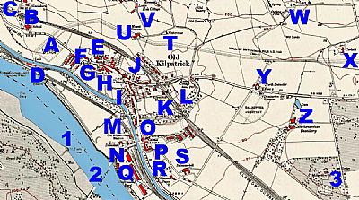
This map is from 1914. Old Kilpatrick is a well established village, but not yet the dormitory town it was to become. It was still essentially rural. NLS © as ref below.
A = (Site of) Terminal Station ie Old Kilpatrick Roman Fort: B = School on Chapel Hill; C = Gavinburn; D = Ferrydykes including Lock, buildings and Donald's Quay with light; E = Church with tomb; F = Lodge; G = Manse; H = Church Halls; I = Nursery; J = Nursery: K = Patrick Station; L = Lusset Cottage; M = Old Kilpatrick Station; N = Low Dalnottar O = Dalnottar Burn; P = Manse Q:= Shipbuilding Yard; R = Daalnottar House; S = Dalnottar Hill; T = Netherclose; U = Mount Lusset; V = Hole Cottage with offices and kennels: W = Curling Pond: X = Carleith; Y = North Dalnottar: Z = Auchentoshan Distillery; 1 = St Patrick's Stone; 2 = Erskine Ferry; 3 = Mountblow with Lodge.
You can see the Forth anc Clyde Canal making its way to Bowling to the west / left. Dalmuir is in the opposite direction to the east / right. To the north of it ran the N.B.R. Glasgow, Helensburgh and Dumbarton Line. To the south of the canal ran the C,R, Lanarkshre & Dumbartonshire Line.
"A" shows where the Old Kilpatrick Roman fort was. You can see the Antonine Wall running northwards from there and then sweeping eastwards.
ACTION OLD KILPATRICK (AOK) : A WALK THROUGH THE PAST
Memories of Old Kilpatrick. 1940s to the present day. Published by Action Old Kilpatrick with the support of the Heritage Lottery Fund.
2018.
BRUCE, JOHN: F.S.A. Scot. History of the parish of West or Old Kilpatrick and of the church and certain lands in the parish of East or New Kilpatrick. 1893. Republished in 1995 by the Clydebank District Libraries and Museums Department. ISBN 0 906938 11 2. Cordfall Ltd.
GAZETEER FOR SCOTLAND : SCOTTISH PLACES : https://www.scottish-places.info/towns/townhistory377.html
IRVING, JOSEPH. The Book of Dumbartonshire. W. and. A. k. Johnston. Edinburgh and London. 1879.
NATIONAL LIBRARY OF SCOTLAND : MAPS. :Dumbartonshire, Sheet XXII. Survey date: 1860, Publication date: 1864. https://maps.nls.uk/view/228777160
Also :
Dumbartonshire XXIII.9 (Old Kilpatrick). Survey date: 1861, Publication date: 1862. Dumbartonshire XXIII.9 (Old Kilpatrick) Survey date: 1861, Publication date: 1862
and Dumbartonshire XXIII.13 (Old Kilpatrick). Survey date: 1857 to 1860, Publication date: 1862 https://maps.nls.uk/view/74942009
ONLINE ETYMOLOGY DICTIONARY: https://www.etymonline.com/word/kil-#:~:text=first%20element%20in%20many%20Celtic%20place%20names%2C%20meaning,place%2C%22%20from%20Latin%20cella%20%28see%20cell%29.%20cell%20%28n.%29
WIKIPEDIA : https://en.wikipedia.org/wiki/New_Kilpatrick#History
