
KILMARONOCK CASTLE / Mains Castle, near Endrick Water
This is today little more than a ruined tower, but records such as that for Ancient Monuments describe it as somewhat more. It dates from the late fifteenth to the early sixteenth century.
The tower has four storeys, the first three of which have been vaulted, and a garret. A rectangular structure that once projected from the S wall may have been a latrine turret. The keep is rubble built using grey and red stone with fine red freestone for dressings and quoins. The main entrance was in the second floor in the centre of the E wall. It led straight into the hall and communicated with a stair in the SE angle. ...a small minstrels' gallery sits above the main entrance. The kitchen was contained in the E portion of the first floor with scullery in the W. The lower floor contains a cellar in the W and a prison in the E, each independently accessible by stairs from the floor above. [Canmore].
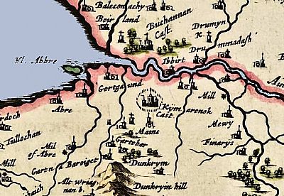
Here Pont depicts "Kijmaronock Cast" ie Kilmaronock Castle somewhat fancifully complete with secondary towers and flags and encircled by palisading. Buchanan Castle just over the Endrick Water doesn't get the same status. This suggests that Kilmaronock Castle was the more significant at that time. NLS © as ref below.
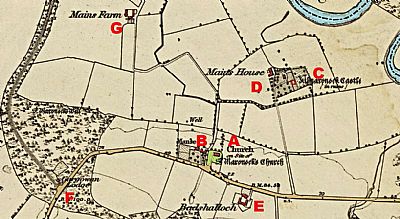
In this map of 1860 you can see the castle already in ruins at C. Next to it at D is Manse House. Kilmaronock Kirk is at A built on the ruins of an earlier church. At B is its manse. Other buildings nearby are Badshalloch house at E; Gargowan Lodge at F and Mains Farm at G. The main road is shown in light yellow and the Endrick Water is in blue. NLS © as ref below.
ANCIENT MONUMENTS website : https://ancientmonuments.uk/127626-kilmaronock-castle-lomond-ward#.X9UU7OZxdPY
CANMORE : https://canmore.org.uk/site/43404/kilmaronock-castle
