
MITCHELL WAY
During 2023 one side of Mitchell Way gets a long anticpated demolition. The premises decayed over what seemed like many years to a state when everyone who knew them felt they just had to go. You can find a record of their state just before demolition here: index.asp?pageid=733663
But in their heyday they were considered an innovative layout with housing above shops forming a friendly and safe urban mall. Several pedestian access points with metal arches and a subtle bend created an intimate space. At one end was the CoOp supermarket facing across to Mckays fashion shop and at the other the then almost iconic two storey CoOp department store. A string of smaller shops and other businesses linked these two ends. Nearby carparking was generous.
Move on into the 2020s and the scenario is much altered. Some shops are struggling. The large CoOp department store has shrunk down to an Iceland outlet. The supermarket remaining at the top end on Main Street.The flats above the one side of the mall over time had proved not to be practical and therefore not popular. Great improvements in the approach hard landscaping had already been made though at the Main Street end.
Public consultations by the West Dunbartonshire Council confirmed the public feeling and developers eyed this and the surrounding areas. It was decided to take down the double storeyed section on the one side. New development is on the cards (2023), but while the newness will be a relief, we can only wait to see if the ambience and scale really match up to what was once here. The public generally see newness as the answer.
To get all this in perspective we need to step back to an even earlier era. Mitchell Way was Mitchell Street linking the Main Road with Bank Street. It was flanked by housing. At the bend a road called Random Street branched off to the south east. Its name may seem to depict a state of confused town planning, but it was parallel with Bank Street and reflects a strong association with a Tobias Smollett character.
The Vale of Leven History Project website notes that Mitchell Street was one of the oldest Streets in Alexandria dating back to about 1800. It was a very busy street, being the first vehicular link going south between Main Street and Bank Street. From the 1880's onwards it housed the Co-op Yard - stables, garages, and even the Co-op's own electricity-generating station to begin with.
Latterly the Salvation Army Hall stood next to the entrance to the Co-op Yard, in what had originally been an old single storey house. A religious group who eventually moved to Susannah Street had converted this into the Ebenezer Hall. Then the Salvation Army moved in and used it as their Hall, until it was demolished about 1973.
There were also a number of tenement buildings dating from 1810-20 as well as Argyll Terrace, one of the best red sandstone buildings in Alexandria, which occupied almost half of the north side of the Street. Its demolition in 1972-3 was particularly stupid. Random Street ran due south to John Street from about Mitchell Street's mid-point.
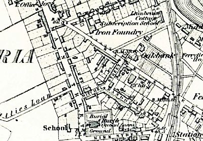
A mao from 1860. See reference below. You can see Mitchell Way's predessor, Mitchell Street. Besides replacing the buildings along its length, extensive clearing was done for the generous carparks. While Mitchell Way itself became a pedestrianised mall, this was the era of the private car. Main Street has a mix of housing and commerce. Also note St Andrews Church, a school where the Community Centre now stands, Oakbank house where Aldi now stands and even an iron foundry. NLS © as ref below.
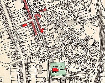
Not that much had changed by 1914 as in this map. Key buildings that still remain are coloured red and others that remain in pink. Mitchell Street preceded Mitchell Way which explains the bend. St Andrew's Church and churchyard are to the south with running along on side. Everything else behind the church and on bothh sides of Mitchell Street was cleared away for the then new Mitchell Way and parking. Some of the older commercial buildings on Main Street were rebuilt. NLS © as ref below.
As this section is being written up it is late 2024. Lidl is completing its new store in counterpoise and competition to Aldi across Bank Street. We can only wait to see the impact. Will Iceland (in what was the main CoOp building at the bottom of Mitchell Way) and the smaller CoOp supermarket at the Main Street end survive? Or will they re-invent themselves? Planning philosphy inevitably talks of places for people, places for relaxation and socialising in amongst commercial requirements; places to live so that such areas are constantly populated and alive. Mitchell Way was designed with this in mind roughly based on its historical precedent. So what went wrong? There were some design flaws in the residential component. The main flaw was maintenance to a suitable standard. It was done, but reactively more as an afterthought. The main threat though was changing habits and expectations of its users. The car had already long dominated local planning and cheaper prices and availability of goods denied much of the social aspects of urban spaces. Add the relative immediacy of internet shopping and the urban fabric changes dramatically. Alexandria no longer has any urban social space. Fountain Square now looks great again after its refurbishment and fountain restoration. That epitomises the ambitions of the town. But it is not a social space. We have town planning, but no urban design to meet that need.
Mitchell Way was created as social space within a commercial concourse. We now have less than half of it facing carparks and large new budget shops. What will the future hold?
If you look closely at the map above, running north-west / south- east from Mitchell Street to Church Street is Random Street. This was presumably named after Tobias Smollett's character, Roderick Random, but that name seems to conjure up what was to follow. None of what followed was actually random. Commercial pressures, competition and opportunities defined the rest as development evolved and slotted into the basic, somewhat simplistic town planning zoning.
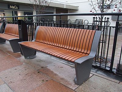
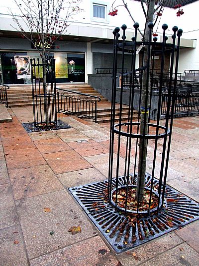
Smart new steps, benches and tree surrounds installed by the Council give a much more optimistic atmosphere at the Main Street end.
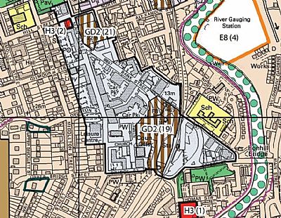
We end this look at the changing nature of the area within Alexandria at and around Mitchell Way with this map extract from the Local Development Plan 2 of 2016. (LDP 3 is currently being formulated - 2024). Pale blue is "town centres" and vertical brown stripes is "development opportunity".
NATIONAL LIBRARY OF SCOTLAND MAPS (NLS) : an extract from the map for Dumbartonshire, Sheet XVIII. Survey date: 1860, Publication date: 1864.
Dumbartonshire nXVIII.6' Revised: 1914, Published: 1919. https://maps.nls.uk/view/82874202
VALE OF LEVEN HISTORY PROJECT website. : http://www.valeofleven.org.uk/scottishplacenames/Mvale_names2.html
WEST DUNBARTONSHIRE COUNCIL - Local Development Plan : https://www.west-dunbarton.gov.uk/council/key-council-documents/local-development-planning/development-plan/
