JAMESTOWN
today Jamestown is part of the Vale of Leven conubation. When you travel through it you will notice several old buildings. If you live there you most probably have one of the numerous comfortable modern houses.
The village of Jamestown grew up around the junction of the southern road to Balloch Ferry or Boat, from the Dumbarton - Stirling road, or more accurately track, until it was built up into a military road around 1755. This road down to the Ferry over the Leven is now called Dalvait Road, and indeed has been called that for at least 250 years. References to the land of Dalvait go back to at least the 16th century and its Gaelic derivation from the “field of boats” indicate that the area was used by fishermen who fished for salmon in the Leven at designated places or “shots”.
Dalvait features prominently in the origins of Jamestown, for two reasons. Firstly, the Mill of Balloch stood close to Dalvait Road, where it crosses the Carrochan Burn, and it was from the dam for this mill that Jamestown took its first name. The mill was originally driven directly by the Carrochan Burn, its waters being controlled by a dam which was built at the confluence of Ballagan and Carrochan Burns, just behind where Balloch Library now stands {The library has since moved into the new school}.This dam was swept away in a flood about 1850, to be replaced by Jamestown Dam which was the centrepiece of the village for about 100 years. [Vale of Leven History Project].
The Frances Groome's Ordnance Gazetteer of Scotland of In 1882-4, described Jamestown as a small town in Bonhill parish, Dumbartonshire, on the left bank of the river Leven, 6½ furlongs N of Bonhill town. It shares in the busy industry of the Vale of Leven, and has a post office, a station on the Forth and Clyde Junction section of the North British, a quoad sacra parochial church, and a public school. ...[Gazetteer]

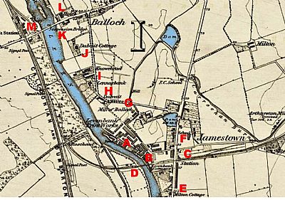
This map dates from 1860. Quite where Jamestown begins and ends is obscure. Bonhill to the south east. Balloch to the north. But its epicentre is fairly clear. It is approximately at the crossing of the Main Street northwards and the Forth and Clyde Junction Railway heading east to Stirling. NLS © as ref below.
A = Levenbank Print Works; B = railway platform serving the print works; C = Jamestown station; D = Stuckie Bridges over the Leven and the lade; E = Milton Cottage; F = School (an earlier one); G = Mill of Balloch; H = Dalvait (house); I = Lennoxbank (house); J = Knowehead (house); K = Dalvait Cottage; L = Suspension Bridge; M = Balloch Station.
NATIONAL LIBRARY OF SCOTLAND : MAPS : Dumbartonshire, Sheet XVIII. Survey date: 1860, Publication date: 1864. https://maps.nls.uk/view/228777145
ORDINANCE GAZETEER OF SCOTLAND .Frances Groome's Ordnance Gazetteer of Scotland of 1882-4 per A Vision of Britain Through Time : https://www.visionofbritain.org.uk/place/22168
VALE OF LEVEN HISTORY PROJECT : https://www.valeofleven.org.uk/jamestown.html

