
CLYDEBANK
Clydebank is the most bustling part of West Dunbartonshire. It has a large shopping centre which straddles the Forth and Clyde Canal and an extensive business park besides numerous industries spread mainly along its length parallel with the Clyde.
According to Wikipedia, Clydebank is located within the historical boundaries of the ancient Kingdom of Strhclyde, the Mormaedom of Lennox and the Parish of Old Kilpatrick. (12th century), on the north bank of the River Clyde.
Before being formally part of West Dunbartonshire, it was founded as a police burgh on 18 November 1886.
The town thrived during the 19th and early 20th centuries as a shipbuilding and heavy engineering centre. It began as a town when J&G Tomson opened their shipyard in 1871, and grew rapidly with the construction of Europe's largest sewing machine factory by the Singer Company in 1882. Clydebank became a burgh in 1886 and had a population of 43,000 by 1913. [Clydebank Heritage Trail brochure].
And so the town spread, subsuming Old Kilpatrick and Dalmuir and requiring new housing such as at Duntocher, Faifley Hardgate. See DUNTOCHER, FAIFLEY AND HARDGATE
Until this stage, the areas of Clydebank had been very rural. Even with the advent of the two major industries of sewing machines and shipping, the general aspect was of farms and fields. But the industries boomed and attracted the attention of the Nazis during WWII. As a result of the raids on the nights of 13 and 14 March 1941, the town was largely destroyed and it suffered the worst destruction and civilian loss of life in all of Scotland. 1,200 people died, 1,000 people were seriously injured, and hundreds more were injured by blast debris. Over the course of the two nights, a total of 439 Luftwaffe bombers dropped in excess of 1,650 incendiary containers and 272 tonnes of bombs. [Wiki].
Trying to find a concise history of Clydebank is difficult. Certainly its later history is dominated by the Blitz. Perhaps its earlier history is less tangible because places like Old Kilpatrick and Dalmuir which became part of it have their own stories to tell. See DALMUIR
Our website doesn't focus anywhere on WWII as so many others do it better, but Clydebank during this period is discussed under WAR : WEST DUNBARTONSHIRE AT WAR and WAR MEMORIALS : CLYDEBANK
Clydebank today has been reborn and even today work continues on its regeneration.
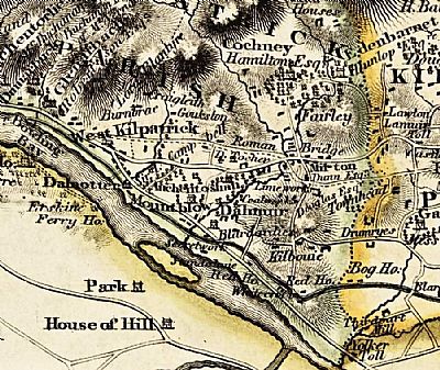
In this map by John Wood of 1818 Clydebank is not even mentioned, but you can see Kilbouie Road (sic) leading south to north. The place names of Dalmuir, Mountblow and West Kilpatrick (the name before Old Kilpatrick) can be found. NLS © as ref below.
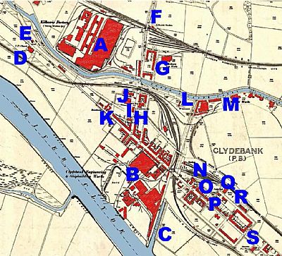
By 1896 the area is dominated by the dual industries of the Singer Sewing Machine factory and the Shipyard. NLS © as ref below.
A = Kilbowie Factory (Sewing Machine etc); ie the Singer Sewing Machine Factory; B = Clydebank Engineering and Shipbuilding Works: C = Old Canal ie the remains of the infilled Forth and Cart Canal; D = U.P Church; E = Standalane: F = Kilbowie Station; G = Kilbowie Iron Works:; H = Conservative Club; I = Meth Chap ie Methodist Chapel; J = School; K = Brickhouse: L = Whitecrook; M = Chemical Works;: N = Station: O = St James Church; P = Bank: Q = Public Hall; R = Police Station: S = Hamilton Free Church.
The Forth and Cart Canal connection to the Forth and Clyde Canal was abandoned. See FORTH AND CART CANAL Clydebank, but it had a lasting impact on the road layout. You can see the Forth and Clyde Canal running east - west in pale blue. The railway north of it is the Glasgow Dumbarton and Helensburgh Line and south of it the Lanarkshire and Dumbartonshire Railway.
You won't find the Clydebank Town Hall, yet. Its foundation stone was only set in 1900.
NATIONAL LIBRARY OF SCOTLAND : MAPS : Mapmaker: Wood, John, ca. 1780-1847 Title: Map of Dumbarton Shire from actual survey ... / by John Wood ... T. Clerk sculpt... Date: 1818. and
Dumbartonshire XXV.2 Revised: 1896, Published: 1898
WEST DUNBARTONSHIRE COUNCIL with David Carson. : https://www.west-dunbarton.gov.uk/media/2619058/clydebank.pdf
WIKIPEDIA : https://en.wikipedia.org/wiki/Clydebank
