ARDOCH on the Firth of Clyde
ACCESS : This cluster of houses is on the main road between Dumbarton and Cardross. Access to the shore is easy on foot, but be aware of the need to park away from the underpass as described below. This necessitates crossing what can be a busy road, or walking on its rough verge. An alternative would be to walk along the shore from Cardross.
///cringes.fall.vowed Footpath down to the shore.
This is small cluster of houses on the road out of / into Dumbarton or Cardross, depending on your point of view, yet it has some features worth noting. Technically it is outwith West Dunbartonshire and on the Argyll and Bute side, but tends to feel like part of Dumbarton. Three houses of note are Leabank House, Burnbank House and Ardoch House (all private).
LEABANK HOUSE : On the very edge of West Dunbartons is this large house built in 1857 with stables and a coach house; a lodge, a timber chalet and an area of parkland and woodland. Although not a listed building, the main house has been described as a fine example of a Victorian villa.
BURNBANK HOUSE : This is a lovely large old house overlooking a deep garden and beyond the Firth of Clyde. An interesting feature is the pointed arch upper side windows. Naturally it sits alongside a small burn.
ARDOCH HOUSE : The listing text tells us : Circa 1780 with mid 19th century tower addition and alterations and that Robert Cunninghame Graham of Gartmore acquired estate in 1770 and built Ardoch Cottage a Georgian Colonial style cottage with splayed wings. The central tower is a later addition. Not to be confused with Ardoch House, which has been demolished. What is now called Ardoch House was built as a cottage.
As for Cunninghame Graham, "Don Roberto", well, he was a Scottish politician, writer, journalist and adventurer. He was a Liberal Party Member of Parliament (MP); the first ever socialist member of the Parliament of the United Kingdom; a founder, and the first president of the Scottish Labour Party; a founder of the National Party of Scotland in 1928; and the first president of the Scottish National Party in 1934. See below for a link to more about him. See index.asp?pageid=718446
Wikipedia tells us more about the origins of Ardoch:
Over the centuries, Ardoch became a key estate in the region, serving as an important seat of power. A mansion was constructed on the estate in the early 17th century, replacing an earlier medieval structure used by the family from the 1300s. This mansion disappeared in 1874.
The description on Canmore also notes that the house was replaced by a farmhouse called Ardochmore.
For centuries, the estate remained under the stewardship of the Bontine family. It was eventually sold in 1987, and the title of Baron of Ardoch passed to its current holder, Tommy MacKay, who assumed the title in 1987. The barony continues to represent an essential part of Scottish heritage, particularly in the Dumbartonshire area. [Wiki]. The Bontine connection meant that Cunninghame Graham inherited land here and built the current Ardoch House.
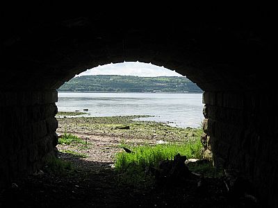
As noted at the outset, there is access here to the shore and at low tide to the YAIRS See index.asp?pageid=715973 To reach the shore from here, park either at the large but rough layby on the shore side, or in the space at the farm road junction on the Dumbarton end. (You cannot park near the underpass itself). This is a busy road, so caution is required to cross it. From there on it is a short walk down under the railway. It is advisable to check the tides before approaching as there is little walking space above the high level mark.
Also see FISH YAIRS, RIVER CLYDE index.asp?pageid=715973

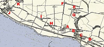
In this map extract of Ardoch c 1860 you see the coast with part of the "Old Fish Yair within the tidal area at the bottom. Just in from that is the railway. A burn runs under the line from a small wooded area and the main road. Most buildings still exist much like that depicted. A newer large house known as The Manor has since been built in the space between these and the current Ardoch House, in stone which makes it look older. Ardoch Gardens can be made out to the west on the other side of the road. It still exists and several houses have been built between it and Burnbank House. Other buildings have gone, replaced or have been extensively modified. Some names remain familiar. NLS © as ref below.
A = Ardoch Gardens.> late 18th century house listed “C”with a walled garden.; B = Burnbank; C = Ardoch Cottage, the predecessor of the grander Ardoch House; D = Lee. This became Lead Farm Cottage, Lea Farm having stretched from the shore to up the hill; E = Ardochmore, since becoming Ardoch Farm House; F = Ardochmore Barn, now a ruin. The barn was formerly the offices of Old Ardoch House, the castle of the Bontine family, now demolished. The former walled garden of old Ardoch House is listed separately. Ardoch, a later house, is listed separately; G = Site of the original Ardoch House; H = Wester Ardoch, approximately where the modern Westerhill Cottage now is; I = Wester Hole where Westerhill Farm steading and stables now are; J = Clydeview. This is the edge of Cardross; K = Craigend. This farm house is just beyond where the cliffs or craigs reach their western end. (We find Havoc Hole at their eastern end).

MACKAY, TOMMY website : http://www.tommymackay.com/mackay-of-ardoch/
NATIONAL LIBRARY OF SCOTLAND : MAPS : Dumbartonshire, Sheet XXI. Survey date:1857-60,Publication date:1863-64. https://maps.nls.uk/view/74426623
WIKIPEDIA : https://en.wikipedia.org/wiki/Cunninghame_Graham
https://en.wikipedia.org/wiki/Baron_of_Ardoch

