
BOWLING
Bowling is a village on the Clyde overlooked by the Kilpatrick Hills. To the east is Old Kilaptrick and to the west is Dumbarton. While small, it has an interesting history that includes the Littlemill Distillery and a shipyard. Its main claim to fame though is that it is the western terminus of the Forth and Clyde Canal where it enters the Clyde. It is also thought of, a little abiguously, as the extremities of the Roman Empire in Scotland. The nearest Roman fort was in Old Kipatrick where the Antonine Wall reached its westernmost end. We can be pretty sure that Romans wandered about here, but their impact is neglible.
There are no known records of the origin of the name Bowling. We all know the game of bowls or of bowling of a ball. But did that use of the word come from the smoothness of movement, as the Mirriam Webster dictionary suggests, as in flowing? That could make sense if referring to the way the Clyde flowed at this point. Some have suggested that it came from a description of the coastline of the Clyde here, a natural bowl or bay suitable for boats to moor within. But we are only guessing. This sounds plausible though. The Dalmadan / Colour on the Clyde website notes that : Until the latter years of the eighteenth century, the Bay of Bowling was best known for its sandy beach in the bend of the Clyde just upriver from the rocky Dunglass Point where the ancient keep of the Colquhoun Family stood in ruins. There was an inn and a hotel and it was a pleasant, sheltered spot for bathing. At Littlemill, on the Auchentorlie Burn, there was a disused mill that by the early 1770s had been at one time used as a bleaching works and then taken over as a distillery. [Colour on the Clyde]. It was only when the Forth and Clyde Canal met the Clyde here, that Bowling took off.
Bowling village has a distinct ambience although this is somewhat eroded by its through road between Old Kilpatrick and Dumbarton. It is a popular cyclists stopping place, the cycle track passing along the disused railway line route.
Its heart though is within the area surrounding Bowling Basin and the canal. This is a really charming and picturesque setting full of boats and some good shops and a cafe. The Bowline refers to the restored cycle way over the railway bridge above the basin. Well worth a visit. So much more could be made of Bowling village itself.
Also see : BOWLING SHIPYARD; LITTLEMILL DISTILLERY, BOWLING; BOWLING HARBOUR : CANAL BASIN and other related subjects.
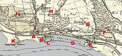
In this map of 1860, we see the village still a loose cluster of buildings. The canal is established and the ferry service to and from Greenock is running with the inn acting as a useful stop over point and watering hole. NLS © as ref below.
A = Littlemill Distillery; B = Frisky Hall, the inn; C = the slipway and wharf from which the ferry service ran. This developed into the shipyard; D = Bowling Harbour; E = Bowling Basin and the end of the Forth and Clyde Canal; F = Glenarbuck House and estate buildings; Dunerbuck House; Auchentolie; I = Auchentolie Cottage; J = Auchentolie House; K = Dunglass Castle, house and Bell monument.
DALMADAN / COLOUR ON THE CLYDE : https://www.dalmadan.com/?p=61541
NATIONAL LIBRARY OF SCOTLAND : MAPS : Dumbartonshire, Sheet XXII. Survey date: 1860, Publication date: 1864. https://maps.nls.uk/view/228777160
