
DUMBARTON HARBOUR, the River Leven, Dumbarton.
ACCESS : Easy access to what is now a walkway alongside the Rvierside Lane parking.
Dumbarton Town Centre Conservation Area.
For the housing of the same name see index.asp?pageid=728305
Also see RIVER - CHANGING PROFILE index.asp?pageid=736695
RIVERSIDE WALK
Dumbarton is well known for its ship building. But it also served as a port. Before any quayside was built, early inhabitants and perhaps Romans and Vikings would draw up their boats on the muddy shore out of reach of the tides and currents. Shipbuilding is discussed under the DENNY TANK MUSEUM index.asp?pageid=716335, DENNY SHIPYARD index.asp?pageid=717882 and WOODYARD / SANDPOINT index.asp?pageid=716648. The subject is a major factor in the development of Dumbarton. A walk along DUMBARTON WATERFRONT PATH index.asp?pageid=715736 will take you through what was the industry's epicentre and show you where it all happened.
What we are looking at here though is Dumbarton as a port; a place to import and export goods or transfer passengers. It is this role that supported and stimulated its economy. And it was even a factor in its long running, sometimes awkward, contest with Glasgow further upstream to be the main commercial port on the Clyde. History shows that other ports took precedence, but the role of Dumbarton as a port must not be underestimated or overlooked. The way that it offered a degree of shelter from the more exposed stretches of the Clyde, the way that it stood out so much with its iconic Dumbarton Rock and its links upstream of the Leven to industries such as that of textile dyeing and printing gave some useful edges over its rivals.
The River Leven is well known for being one of the fastest flowing rivers of its size in Scotland. How it could offer shelter towards its confluence with the Clyde is explained by its widening out and slowing down thanks to two stretches of mudflats. Both of these are now gone. One was below Dumbarton Rock where the shipbuilding industry was to develop. One of the two basins that replaced it still remains. The other was in the form of a large lagoon that was infilled and became the Broadmeadow Industrial Estate. With the river thus slowed down in its flow, it was a suitable place to bring in ships from the mightier Clyde beyond the Rock. And it also meant that it was reasonably easy to establish basic quays and jetties without too much danger of storm damage.
If you look at the picture by W. L. Leitch below, you will notice some commercial activity on both sides of the Leven.
That on the west side has only the most rudimentary of quays built of timber. This was developing as a timberyard and what you see is both timber stock and something to dock against. You can also see St Serf's Chapel and a large timber ship being constructed.
On the east side, the side of the small town of Dumbarton, there are already some warehouses, service buildings and signs of proper stone quays. There are two spires in the picture. The one to the right is that of Riverside Parish Church. The other is that of the Academy Building, now the West Dunbartonshire Council offices. In the left distance is a large hill shown of similar height to Dumbarton Rock. This is Dumbuckhill before the quarry had progressed much. Dumbowie is to its immediate left. You can also see that the area between these hills and Dumbarton Rock is very low lying with almost no development on it.
 The town and castle of Dumbarton from the Leven.
After: William Leighton Leitch; Print made by: James Duffield Harding. 1847.
© The Trustees of the British Museum.
Comapre this to the maps of 1859. The river edge is little different, but we begin to see greater formality amongst the related buildings.
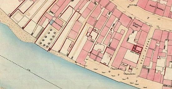
Dumbarton town quay.
Extract from Dumbarton [1859] - XXII.6.11.
© NLS.
There is now a properly recognised quay and Quay Street links it with the High Street. There are two weighing machines on the quayside and a police station on Quay Street. Unsurprisingly there is also a Steamboat Tavern. Quay Street aligns across the HigH Street with the Tolbooth, then the centre of local administration. It also served as a prison. By the date of this map, though, it had been replaced by Heggies Building. Also making the most of both the commerce of the High Street and trade from the quayside was the Elephant Hotel. Right next to that was the Glencairn Greit House. This centre of commercial interest of the Earls of Lennox in its early days was a fishmonger by 1893. It had its own direct link to the quayside, a narrow pend that remains to this day complete with its vaulted rubble throughway. While Glencairn Greit House seems to have had the upper hand in terms of location and connectivity with the river and so riverborne trade, several other properties gained river access too.
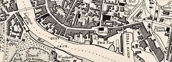
Dumbarton in 1896.
Dumbartonshire Sheet XXII.NW.
© NLS.
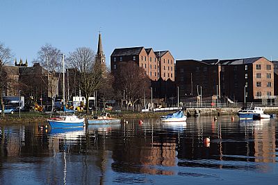
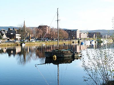
When you walk along the quayside today you may notice how the wall meanders reflecting its piecemeal development. There is still a small slipway and other signs of its maritime usage. The Leven is very prone to the tides. Any craft that docked here needed to have that in mind. Many were flat hulled and simply sat on the mud until the next high tide, but those with keels would need to time their docking accordingly.
It is sad to see the river with the tide out as there is then a great amount of rubbish visable and amongst that are the remains of abandoned boats. It is a dream that may one day come true that the river will be cleaned and made usuable for visiting craft again. Some boat users make use of the centre of the river for mooring and Sandbank Marina is just across the river. Some visits are made by RIBs coming down from Glasgow on leisure trips.
The pandemic has dented our ability for farsighted ambitions, but just imagine if tourists could be brought from the cruise liners docked at Greenock across here by tenders to the amazing historic town of Dumbarton, the Ancient Capital of Strathclyde, the Gateway to the North, the birthplace of the Cutty Sark....
While Dumbarton is much in the local consciousness as a shipbuilding centre, its role as a harbour is almost forgotten. That is being rectified by the naming of new housing called Dumbarton Harbour.
Tides continue to have a major influence. In our comfortable modern lifestyle our main concern seems to be finding parking rather than moorings. But each spring tide, a tide just after a new or full moon, when there is the greatest difference between high and low water, there is a risk of finding part of the parking area under water. If this coincides with heavy rains, perhaps added to by meltwater from the hills upstream, then this can be somewhat awkward. The River Leven swells as it meets the River Clyde and finds no relief where there used to be mudflats. The river has been reduced further in width with more infilling in recent years.
These days it is difficult to imagine the number and size of ships being built here and launched into the Leven and onwards to the Clyde. Today we see several wrecks of smaller craft languishing in the silted basin. Some of these are recorded under DUMBARTON WATERFRON PATH : index.asp?pageid=715736.
But the working harbour used to stretch up as far as the bridge. The quaysides are still there. The potential for utilising this for berthing of craft from further afield seems hardly viable. During 2024 the Council at last decided to rid the river of the several wrecks, not only a technical challenge, but a legal one too. Most of those are within the wider basin, but a few litter the upper reaches as well.
Looking across from the lawns of what were the Woodyard works towards the quayside on the Dumbarton town centre side.
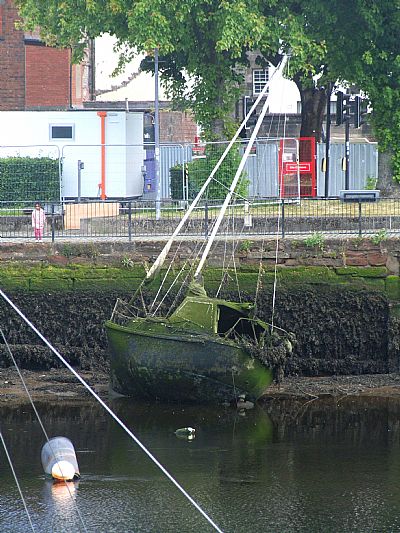
This picture was taken in mid-2024. The yacht long abandoned although the sails remain in place. Behind it work has been started on the rear of Glecairn Greit House. This will be the modern museum section of the restored historical house that used to be the prime trader with its own quay.
Sometimes sunken boats are recoverable - even if they look like something from the netherworld.
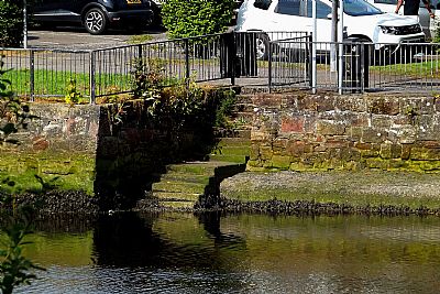
There are just a few vestiges of this being a usable quaysde; the wall and the area above it being modified for parking with a footpath and some trees and benches. But there are still some steps giving access to the water edge. This is one of them. It is possible to reach the river bed at very low tide. But BEWARE. The steps can be very very slippery and it is not recommended.
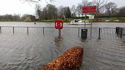
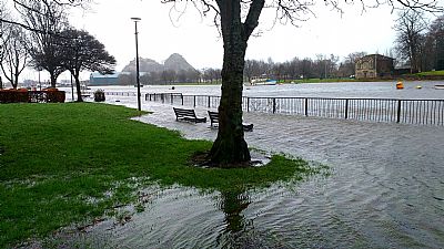
The River Leven is tidal. It meets the mighty Clyde just beyond this point. A boon to early shipbuilders when launching ships - as long as the timing was right. Extreme high tides occur a few times a year, such as at spring tides. Add to that downflow after heavy rains or snowmelt. As the basin has been reduced by infilling, there is reduced capacity to temporarily accomodate this and the situation gets exacerbated. These pictures were taken in the spring of 2022 in the Riverside Lane carpark.
GEOGRAPH.ORG : https://m.geograph.org.uk/photo/5262506
NLS : https://maps.nls.uk/view/74415249
