
HIGHLAND BOUNDARY FAULT
The Highland Boundary Fault transverses a bit of West Dunbartonshire and knits it with Stirlingshire to the east and Argyll and Bute to the west. We see it as to emerges mysteriously from Loch Lomond and then dips again. We recognise it topgraphically as a line of islands that include Inchmurrin, Creinch, Torrinch, and Inchcailloch.
To the west it is aigned roughly southwest to northeast. It runs from Lochranza on Arran and bisects Bute before crossing the Cowal and Rosneath peninsulas. To the northeast it continues to Aberfoyle, then Callander, Comrie and Crieff. It then forms the northern boundary of Strathmore and reaches the North Sea immediately north of Stonehaven. From our vantage point at Loch Lomond we see it rise up to Conic Hill.
You can read up further about the actual dynamics of all this on the links below, but for the moment it is worth considering the enormous dramas that led to its creation.
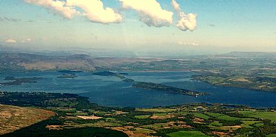
The fault line is clearly seen in this photo taken from the sea plane. It forms a very linear arrangement in the islands (as compared to the others to the north). Conic Hill and Stirlingshire appear in the distance / east; West Dunbartonshire to the right / south and Argyll and Bute below / west.
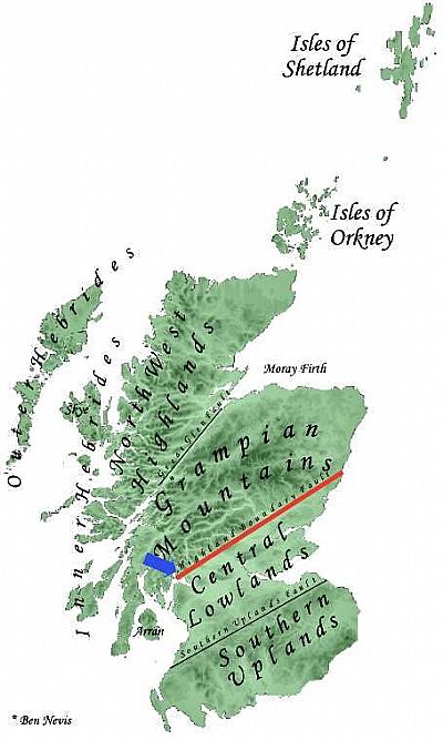
This map comes from Wikipedia and shows the Highland Fault line highlighted in red with the blue arrow indicates Loch Lomond. This is naturally an oversimplification, but clearly shows West Dunbartonshire south of that line in the Central Lowlands. However West Dunbartonshire also reaches up and over Inchmurrin so including some of the very Fault Line. [Wiki]'
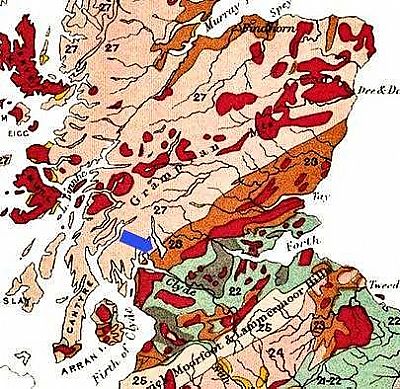
Again a map from Wikipedia, but in more detail. This one shows the geology. For our purposes here we note the conjunction of two different geological systems running through Loch Lomond at the point shown by the blue arrow. [Wiki].
These elongated islands and hills are amazingly visible and tangible emanations of the dramas that created our environment. Consider for a moment the way the vast supercontinent of Pangea split up, its bits drifting across the planet and in some cases smashing into each other to form new continents.
All this was certainly dramatic. And rather violent. When seeing the fault line before you it is natural to then wonder if that terrain is susceptible to more movement. Earthquakes. Well yes!. Perhaps it is because of the noises and vibrations around us that we are unaware of earthquakes in Scotland. Fortunately nothing really severe has happened or is likely to happen, but they do occur from time to time. If you want to track earthquakes in Scotland, have a look at the Earthquake Track website as per the link below. (Pity about the adverts). This opens with the words - Scotland, United Kingdom has had: (M1.5 or greater). 0 earthquakes in the past 24 hours.
EARTHQUAKE TRACK : https://earthquaketrack.com/r/scotland-united-kingdom/recent
WIKIPEDIA : https://en.wikipedia.org/wiki/Highland_Boundary_Fault
