
FORTH AND CART CANAL Clydebank.
ACCESS : This no longer exists, but you can still visit the spot.
///dine.update.spoon (junction with Clyde).
The Forth and Cart Canal was a short 1⁄2-mile (800-metre) link canal which provided a short cut between the Forth and Clyde Canal, at Whitecrook, and the River Clyde. It ran along what is today Argyll Street in Whitecrook, Clydebank. It was aligned with the mouth of the River Cart across the Clyde and was intended to provide a transport link between the town of Paisley, the Firth of Forth and Port Dundas, Glasgow, without having to go via Bowling, some 7 miles (11 kilometres) downstream on the Clyde. The Forth and Cart Canal was closed in 1893. Railway works destroyed most of it soon afterwards.
At the peak of the early progress of industrialisation when canals were seen as the answer to all builk transport, it was envisaged that there would be a whole network of canals linking the major industrial centres across central Scotland. The Cart River across the Clyde from here was seen as a link to other canals, the Glasgow, Paisley and Johnstone Canal being the one applicable here. There is just a small remnant of that one, but it illustrates how this Forth and Cart Canal would have linked up.
The Forth and Clyde Canal may not have progressed very far, but it nevertheless has defined what we see today. The grouping of buildings incorporating the Clydebank Leisure Centre, the West Dunbatonshire Council building and the West College Scotland Clydebank Campus, together with the large carpark, are all within a roughly triangular site against the Clyde. They are reached from Ossian Way which extends off Aurora Avenue. Ossian Way has been built over the infilled canal.
This canal in turn complemented that on the Renfrewshire side to the south where the Glasgow, Paisley and Johnstone Canal was located. That canal was never finished, canal transport being largely overtaken by the new faster and more efficient railway network. Much of what had been completed were infilled. You can still find the Paisley Canal Railway Station in Paisley where that line terminates, the line itself to a great extent laid on the infilled canal.
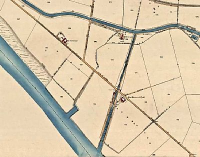
This map is dated 1861 and shows how this canal linked with the Forth and Clyde Canal. The River Clyde aligned diagonally in blue. NLS © as ref below.
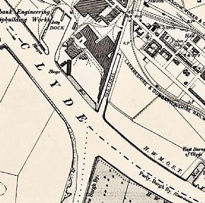
This extract from an 1896 OS map shows how the canal was filled in due to its declining state. The Cart River on the opposite side of the Clyde shows how it was intended to link across.
Reproduced with permission from NLS © See below.
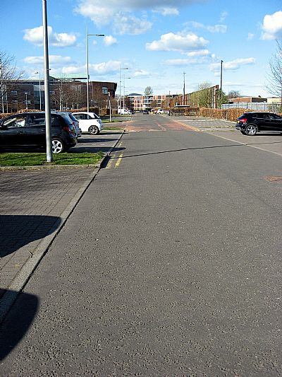
This is Ossian Way, effectively an extension of Aurora Avenue. This is the location of that section of the canal that had been built, albeit not completed and eventually filled in.
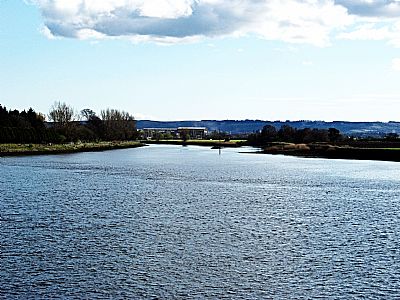
Right across the Clyde from this point is the River Cart to which this canal was intended to link.
EVERYTHING EXPLAINED : https://everything.explained.today/Forth_and_Cart_Canal/
KIDDLE : https://kids.kiddle.co/Forth_and_Cart_Canal
NATIONAL LIBRARY OF SCOTLAND : Full map :
Dumbartonshire Sheet XXV.NW includes: Inchinnan; Old Kilpatrick;...
Date revised: 1896, Publication date: 1899. Reproduced with permission. https://maps.nls.uk/view/75498405
and Dumbartonshire XXVIII.2 (Old Kilpatrick) Survey date: 1857 to 1861, Publication date: 1862. https://maps.nls.uk/view/74942015
WIKIPEDIA : https://en.wikipedia.org/wiki/Forth_and_Cart_Canal and https://en.wikipedia.org/wiki/Glasgow,_Paisley_and_Johnstone_Canal
WOSAS website : http://www.wosas.net/wosas_site.php?id=48427
