HILL OF DUN
ACCESS: On rugged farmland above Bowling. There is little if anything to see.
https://w3w.co/toolkit.revived.handrail
Canmore records a letter by a TC Welsh in 1979 stating that Vestiges of walling, which may have been used to adapt the natural rectangular hollow between two ridges of strata into a dun, were noted, about NS 447 741, on an elevation formed by a rotational slip, with marked E-W outcropping vertical strata. The interior measures 18m by 7m within walls 3m to 4m thick.
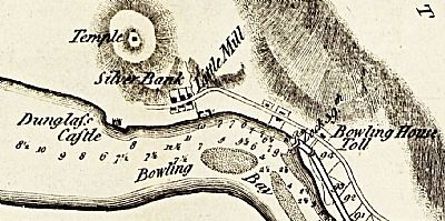
So, difficult to discern if at all even to a trained eye, but it does broaden out impression of early life in the area and complements the hillforts in nature even if not of a specific period along with Dumbuie and Sheephill hillforts also along these hillsides. The cartographer Robert Whitworth, , surveying the area for the Forth and Clyde Canal in 1785 notes a "Temple" on a high point above Bowling. Whether he actually visited it, perhaps to get a better view of the terrain below for the proposed canal, we will never know. It looks a bit fanciful in the map and in reality is further from Bowling village. He could also have simply heard of it from locals and included it for interest, but it nevertheless does indicate a recognition of something up there that is no longer as obvious.
Cup marks on a boulder had been noted by an investigator in 1893, but were not found again in later searches.

This is an extract from a map of 1785 compiled as part of the survey for the proposed Forth and Clyde Canal. NLS © as ref below.
CANMORE : Hill of Dun : https://canmore.org.uk/site/43379/hill-of-dun
THE MEGALITHIC PORTAL : Hill of Dun: Hillfort in West Dunbartonshire : https://www.megalithic.co.uk/article.php?sid=51680
NATIONAL LIBRARY OF SCOTLAND : MAPS : Whitworth, Robert, 1734-1799. Laurie, John, fl. 1757-1800. Ainslie, John, 1745-1828; A plan of the Great Canal from Forth to Clyde / by Robt. Whitworth... and... John Laurie. Drawn and engraved by John Ainslie... 1785. EMS.s.679. One of 4 sheets. https://maps.nls.uk/joins/8211.html

