
CARMAN HILLFORT, the Citadel on Carman Muir
ACCESS : Easy access on foot up a steep slope.
Scheduled monument.
///punch.lemons.clef Centre of hillfort encircling walls.
///shower.bookings.shaky Point at which the dry stane dyke crosses the double walls below the actual fort.
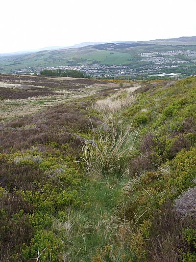
Up on Carman Hill or what some call Mount Mallowe / Mallow / Mallour are the remains of something much grander.. This is NOT just another hill! The hill’s name itself is confusing. Carman Hill applies to the high ground above Carman Muir. A second summit rises ihigher immediately north of that. While that should be called Mount Mallow, this latter name often gets applied to both parts. The word “mount” is a misnomer anyway. What we are more comfortable with for this story is that known more commonly as Carman Hill. Clear? What are these signs of construction? Who built them? When were they built? What were they used for? Many people simply call this the iron age fort. Carman Hillfort or The citadel.
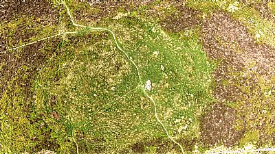
Canmore notes that this fort stands at a height of 230m OD overlooking the Firth of Clyde. The defences comprise two distinct elements, an inner enclosure or citadel, and an outer enclosure with an annexe on the east slope. Within the outer enclosure there are the remains of up to twelve stone-walled houses and there are a further three in the annexe. This citadel is so vast and so mysterious that it needs a complete lecture of conjecture and a publication of its own. All that is intended here is to draw your attention to some key elements. In spite of being in such a prominent position and so large it was only discovered in 1954 during an aerial survey during which it was outlined by a light snow. It has a tendency to blend into the hillside and the bracken. Truly mysterious.
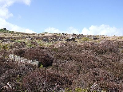
The rock outcrop is clearly visible as are some diagonal drainage ditches of a more recent time. The impressive enclosures are almost invisible from down here and remain difficult to make out even when up there due to the grass and bracken. The best time to visit is late winter or early spring when the bracken has died back and has not yet regrown for the next season. It has never itself been surveyed beyond its basic layout. Basic attempts have been made to do this using a GPS, maps and CAD, but accurate survey requires much more sophisticated means such as LIDAR scanning. The CANMORE website does have a Digital Elevation Map (2017), but detail is missing most probably due to the level of the vegetation at the time.
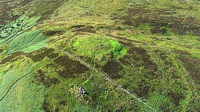
The aerial photographs below were taken by HiSurv and used here with permission. The following are some of the key features. The top view is roughly from the south and the lower one roughly from the north..
● Most noticeable is the roughly east/west dry stane dyke of a much later era. That bisects the hillfort. Its very existence is probably why so little can be seen of any stone walls on the citadel itself. What remains are the very large rocks that were simply too cumbersome to use; the smaller ones having been removed. You can see the modern day footpaths.
● You can make out the stone outcrop that is the most conspicuous feature from below. This is important and may well have been similar at the higher point. Although there is no sign of it having any relevant building form, it is indicative of the other large rocks that could have existed here and that were probably prised from it and rolled or slid down the hill to form other enclosures. Don't get distracted by the modern day cairn – something that is actually illegal on a historical monument.
● The overall round form defined by an embankment is very evident – typical of a fortress or fortified complex. You can also make out inner and outer circles.
● The eastern side forms a gentle slope. (Right on top view; left on lower view).
● The west is more rounded. An embankment defines it and gaps can be identified, the largest appearing to be an entrance way. It is imagined that the whole citadel was further defined by timber palisading which would have made it both impregnable and impressive. There is what looks like an opening on the east side too, but it is thought that the west entrance was the main one. If the whole embankment was surmounted by palisading, then we can suppose that the entrances would have been sealed with yetts also made of heavy timber or woven branches.
● Now look at the north side of the circular mound and you will see a deep ditch encircling yet rising up to about the entrance gap. There is no obvious reason for this as the terrain is not onerous. Was this some sort of lead up route for livestock? Or perhaps a ceremonial route? This latter explanation is preferred. And it may explain the light evidence of fortification. More a designated site of special importance than a refuge or defensive position. Political OR religious. Or a combination of the two.
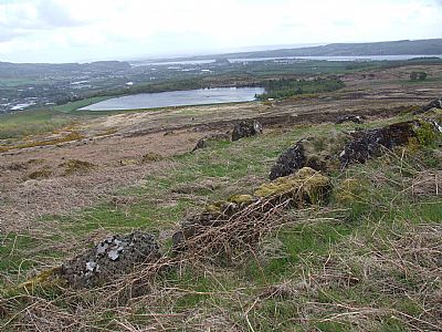
● Note the very large stone enclosures to the east.
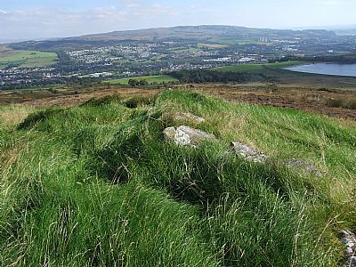
Although very large they can be almost invisible amongst the bracken. What at first sight appear to be just two collapsed walls on closer inspection show them to be formed of very large rocks, segment having two sides – in other words hollow – and forming smaller enclosures over some of their length. It is possible to stand inside some of these hollow sections. They may have had timber roofs. What we cannot see here are several hut rings – the remains of foundation walls of round huts that also occur elsewhere on the muir. The vegetation both hides and exposes. The differences in vegetation can give tantalising clues of such features such as those round spots to the west. Several have been identified within the enclosure. This view looks over the reservoir to Dumbarton Rock, itself once an early defensive establishment of a similar era. To the east, ie a little to the left in the photo, is Dumbuckhill Quarry overlooked by the defensive position of Dumbowie and beyond that something similar at Sheephiill. The topography of all three would aid defence, while Carman Hill is relatively gentle suggesting it did not need to be as readily defensive. In the picture your can see part of the elongated enclosing pens of enormous rocks on the eastern slope. When looking at a historic landscape we need to visually and mentally edit out later acretions and modifications. The view of the citadel on the right is from the neighbouring summit to the immediate north, Mount Mallow, in a way another part of the same hill. Ignore the poles and wires. Ignore the modern day stone cairn on top. Ignore the modern footpaths and some of the patterns in the bracken and grass. Some of these look like a track up from the lower right to the upper left. But what you should notice is the narrow track up from the lower left to the upper right. That is defined by a ditch and to me appears to be either a defined route for livestock OR a ceremonial route up to the citadel itself. Such features are known at other hillforts. If every edge and embankment was pallisaded, all these features would be very well defined. That circuituous ditched route could have forced visitors, friendly or dubious to enter here instead of the yett barred other entrances, so enabling the occupants more opportunity for assessment before welcoming or rebuffing.
The following aerial views are courtesy of HiSurv and used with permission ©.

The two distinct crests can be seen. In the foreground (south) is the stone outcrop and to the rear (north) the actual fort. The dry stane dyke, a much later addition, runs between them. [Photo : HiSurv ©]
Another view looking roughly north.The parallel lines of the lower enclosures can be seen to the right (east). [Photo : HiSurv©]
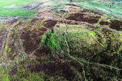
This view looking roughly south shows the curving ditched route up the north side. [Photo : HiSurv©]
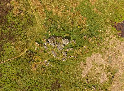
The larger rock outcrop. This looks almost manmade. It is supposed that some of it was prised off using wedges, heat and water along natural fissures. The removed sections would be slid down lower to form the larger enclosure. The remaining bits of outcrop take on an unintended geometric pattern. [Photo : Hugh McArthur ©].
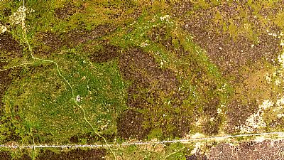
The large rock enclosure is visible in this view to the right / east of the upper round summit. Looking north. These photos were taken in May 2022. Not the best season in terms of vegetation. Bright green is grass or new bracken. Dark brown is old heather and light brown is old bracken. So while the rocks are not readily visible, the vegetation around them clearly demarcates where they are. Also visible is the dry stane dyke to the south and the route within the embankment ditch to the north. [Photo : Hugh McArthur ©]
This is a view of the main round upper area looking north. This is fairly level but with two rock outcrops. The dry stane dyke of much later era is just visible to the south. Modern paths cross the summit. To the left/west an embankment can be seen, demarcated more by vegetation than clear profile. You should be able to make out the small gap which may have been the western gateway. A trained eye can find hut rings, signs of habitation. These are hidden by vegetation, but water collection within them is a clue. These features are not easily discernible on this air view, but there are many tantalising marks. Remember that this site has never been properly and professionally surveyed. With some imagination one can see circles, lines, even rough rectangles. These are more often than not misinterpretations, but could be clues for due archaeological research some time, [Photo : Hugh McArthur ©].

Although not as the occupants would have seen the view, this illustrates the context of Carman Muir as it stretches towards the Clyde.

When you get to the top you may find that others are there first.
The rock arrangements to the east side make little sense at first when the vegetation is high.
As the vegetation goes down in late winter, the parallel walls of the enclosures are much clearer.
The existing rock outcrop is seen to the left. It is possible that there were two outcrops and that the rocks were tumbled or slid down into position.
This is the route dug into the north side of the hillfort. Although now overgrown, it would have provided a defined way up around the hill at this side.
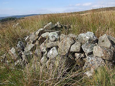
Remember that the rocks for the dry stane dyke would have been taken from the hillfort. This very small enclosure on the dyke would have been a shelter for a shepherd or hunter perhaps in the 18th or 19th century.
It makes for interesting contemplation that the very rocks that comprise the dry stane dyke that runs across this hill and also much of the area, were very likely the very material that the hillfort was built of. The carving up of the landscape into defined and managed farms and estates to this extent came withh the improvements to some extent a consequence of the Scottish Enlightenment. We did not have the drastic "clearances" of elsewhere in Scotland, but the manifestation in stone is similar. Now consider the form of the hillforts such as this one.
We can make out earth ramparts and ditches. With expert guidance you may make out the ring imprints of round houses. Very large rocks appear to have been prised from the rock outcrop summit and slid down into position below. It is expected that to these were added the more manageable smaller rocks which were used as superimposed walling and also infill. And on top of all that would have been timber palisading. What remains is what didn't rot or get removed for the dyking. An excellent impression, a speculation, of what the hillfort looked like can be gained from the artwork of Peter Davis in the book by Angus Konstam, Stronholds of the Picts noted below. (Look for an illustration on Google Images).
ATLAS OF HILLFORTS OF BRITAIN AND IRELAND : http://Hillforts of Britain and Ireland
CANMORE : https://canmore.org.uk/site/42357/carman
GEOGRAPH.ORG : https://www.geograph.org.uk/article/Carman-Hill/2
HISTORIC ENVIRONMENT SCOTLAND website covering scheduled monuments : http://portal.historicenvironment.scot/designation/SM717
NATIONAL LIBRARY OF SCOTLAND MAPS : This website gives you an option to overlay maps of different periods. An excellent option is that of switching on the LIDAR Background Map view. This gives an eerie almost sunset view of the terrain stripped of its vegetation. While this is not in great detail, it does allow you to make out many hillfort features and the well at the foot of the hill.
VALE OF LEVEN PROJECT : http://www.valeofleven.org.uk/contributions/carmanhillfort.html
Recommended reading:
Konstam, Angus : Strongholds of the Picts - Fortifications of the Dark Age Scotland. Illustrated by Peter Dennis. Osprey Publishing. 2010. ISBN 978 1 84603 686 6. While not specifically about this hillfort, it gives an excellent idea of how such forts were built, their context and form. We cannot jump to conclusions that this hillfort even has Pictish associations, but the characteristics would have been common over a wide area.
