
TURKEY RED : 7 - FERRYFIELD PRINT WORKS
ACCESS : This site is easily reached as it sits behind the small shop to the side of the Bonhill Bridge.
NLS ©
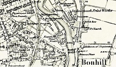
This works was situated on the west side of the Leven immediately up from the Bonhill Bridge. Opposite it is was the Dalmonach Print Works TURKEY RED : 6 - DALMONACH PRINT WORKS. The bridge has been rebuilt since this map was drawn and realigned slightly. The site itself is now modern housing centred around Ferryfield Gardens and reasonably accessible, but best seen from the towpath. The small shop has developed on the site of that small building that can also be made out on the map.
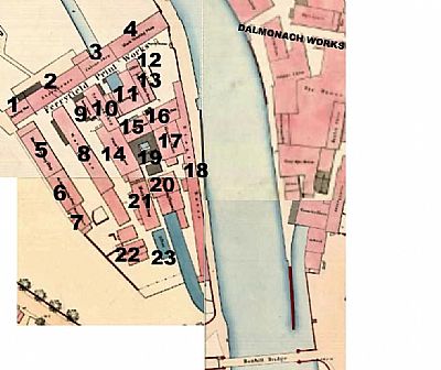
This is a composite map as ref below. To the right / east is Dalmonach Print Works and immediately downstream is the earlier Bonhill Bridge. NLS ©
-
ENGRAVING HOUSE
-
STOREHOUSE
-
COLOUR HOUSE
-
BLOCK PRINTING SHOP with weighing machine outside
-
MACHINE PRINTING SHOP
-
MACHINE PRINTING SHOP
-
SINGEING SHOP
-
WAREHOUSE
-
STEAM BOILERS
-
SCOURING SHOP
-
SHELL DRESSING SHOP
-
OFFICE
-
ENGINE & BOILER HOUSE
-
WATER WHEEL HOUSE
-
WATER WHEEL HOUSE
-
MACHINE PRINTING SHOP
-
BLEACHING HOUSE
-
STENTER HOUSE
-
WASHING SHED
-
PREPARING SHOP
-
MECHANICS SHOP
-
SULPHER HOUSE
-
FILTER
The "mill lade" can be seen on the map in blue. It exits the premises below the towpath, going underground before it reaches the boundary wall and is therefore not shown in blue at this point. Also visible as an indentation in the towpath are the steps for the ferry that predated the bridge even before the one that predated the existing one. As most of these works, there was a drying shed outwith the premises, in this case to the north west. And beyond that was Ferryfield House.
And "Ferryfield"? Well the bridge wasn't there when the works was started and a ferry ran across the river at this point. The steps still exist on the west side of the river, but have disappeared on the Dalmonach side to the east. These steps were fairly substantially laid out and entered the works into what became Ferry Loan. Today that link is obstructed by the railway fence next to Waterside House. (The railway curves away at this point). If you look at the old map above you can see the loan and where the small works was situated including Ferry House.
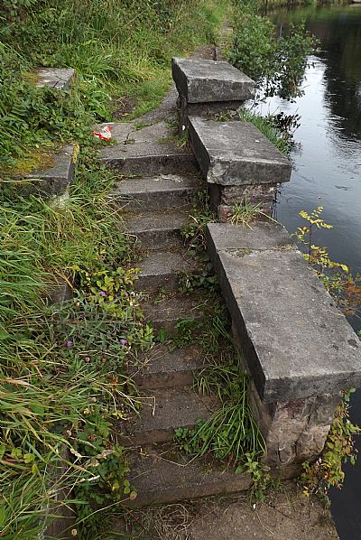
The steps up from the river.
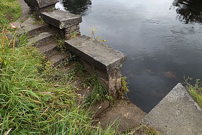
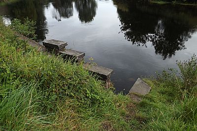
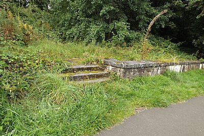
And where they rise up to the works from the towpath.
CANMORE : https://canmore.org.uk/site/128245/alexandria-dalmonach-print-works
COLOURING THE NATION - Wordpress - Project run by the University of Edinburgh and the National Museums Scotland : https://colouringthenation.wordpress.com/turkey-red-in-scotland/
NATIONAL LIBRARY OF SCOTLAND (NLS) : The maps here are reproduced with the permission of the National Library of Scotland.
1860 : Archive title : " Dumbartonshire, Sheet XVIII (includes: Bonhill; Dumbarton; Kilmar... Survey date: 1860 , Publication date: 1864". https://maps.nls.uk/view/74426619
1914 : Archive title : "Dumbartonshire Sheet nXVIII (includes: Bonhill; Cardross; Dumbart. Date revised: 1914, Publication date: 1923" : https://maps.nls.uk/view/75827346
The composite overmarked map was taken from https://maps.nls.uk/townplans/alexandria.html
NATIONAL MUSEUMS SCOLAND : https://blog.nms.ac.uk/2012/06/22/turkey-red-a-study-in-scarlet/
VALE OF LEVEN PROJECT website : http://www.valeofleven.org.uk/valeindustry3.html
WEST DUNBARTONSHIRE COUNCIL : Textile Industry in the Vale of Leven. https://www.west-dunbarton.gov.uk/leisure-parks-events/museums-and-galleries/collections/industry/textiles-and-mills/ and The River Leven Heritage Trail : https://www.west-dunbarton.gov.uk/media/2619077/vale_of_leven.pdf
WIKIPEDIA : https://en.wikipedia.org/wiki/Turkey_red
