
DUMBARTON
There is a great deal on Dumbarton on this website. Look for that in the index or use the Find facility to the right (laptop) or bottom (smartphone).
There are plenty of signs of ancient people around Dumbarton, cup and ring marks and hillforts for instance, so we can be sure that they lived within the area of what is now modern Dumbarton too. We are confident that Romans came here and records show that the Viking certainly did. The latter occupied Dumbarton Castle. In 1263, followers of the Norwegian King Haco pulled their boats out at Arrochar at the northern most end of Loch Long and took them across the isthmus to Loch Lomond. From they sailed south to plunder the settlements around Loch Lomond. (The name Tarbet is derived from the gaelic, An Tairbeart, meaning an isthmus). They evidently then used the Leven to head south to the Clyde, passing through "Dumbarton" as they went.
It is time later that we find them back at Dumbarton Castle. The siege of Dumbarton was a successful four-month siege of the Brittonic fortress on Dumbarton Rock in 870. It was staged by the Viking leaders Amlaib, King of Dublin and Imar. Remember that by that time Dublin was a Vking stronhold and staging post for such attacks. Dumbarton was at that time the capital of the Kingdom of Alt Clut, the only surviving Brittonic kingdom outside of what we now know as Wales It represented a valuable target for the Viking invaders, who were likely motivated by strategic considerations, as well as loot. The attackers may have wished to remove Alt Clut as a maritime power, and the location and defensiveness of Dumbarton itself was of major value. [Wiki].
The name "Dumbarton" comes from the Scottish Gaelic Dun Breatainn meaning fortress of the Britons. Until 1450 it was known as Dunbretane. You may notice in this website that many older sources such as maps use the place name of Dumbartonshire as opposed to Dunbartonshire. The former really took hold in the 1900s. It is softer on the tongue and many prefer it. A natural evolution. But then many still oppose the Dumb- prefering dun- as meaning fortifield or defensive hill.
How the "n" in the name became an "m" seems unclear, but the later evolution of what was Dumbartonshire into, since the early 1900s
The town of Dumbarton grew under the gaze of Dumbarton Rock and Castle; not immediately below it as so many castle dominated towns did, but on a sweep of the River Leven nearby. This was in part due to the swampy ground below the castle which was not suitable for building. In fact it flooded at extreme high tides. That made the castle more strategically secure, but the fledgling town also benefited from its riverside location. Shipbuilding began here in the relative protection of the calmer waters of the Leven, but with easy access to the Clyde and the seas beyond.
The history of Dumbarton Castle is broad and complex, but we have an overview here: DUMBARTON CASTLE AND ROCK
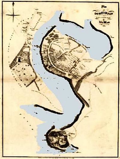
John Wood compiled this map of Dumbarton in 1818. It shows the Leven flowing into the Clyde from the north. The Lagoon which was infilled to form Broadmeadow Industrial Estate is still very prominent. Unlike the following map. the tidal levels are not indicated. NLS © as ref below.
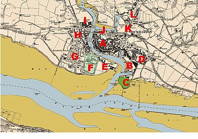
In this map of 1896 you can see Dunmbarton by now well developed. Blue = permanent water of depth and light brown = tidal areas, exposed as mud. That includes the River Clyde and the Leven as well as shipbuilding basins and some park ponds. The lagoon where Meadowpark Industrial now is still remains albeit reduced in size from its original extent. you can also see some of the Port Glasgow timber ponds on the other side of the Clyde. The shipbuilding works on our side of the Clyde had such timber ponds too, to store timber floated across the water until needed for use, but those on the other side were a central storage for merchants. Remnants of these still exist. NLS © as ref below.
A = town centre; B = Leven Shipbuilding Yard with its own Tidal Basin and Timber Pond; C = Dumbarton Rock and Castle; D = Knoxland Square with bandstand; E = Shipbuilding Yard (disused) with a timber pond and slip; F = Levengrove Park, Church (in ruins), bandstand and Lodge; G = Kirkton Hill with 2 x old quarries, Methlan Park, Garmoyle, Dunstane, Levenford and Helenslee; H = Dennystoun with U. P. Church & Sunday school and school; I = Dennystoun Forge, Levenbank Foundry, wharf and Dalreoch Station; J = Engine Works; K = Meadow Park; L = Townend.
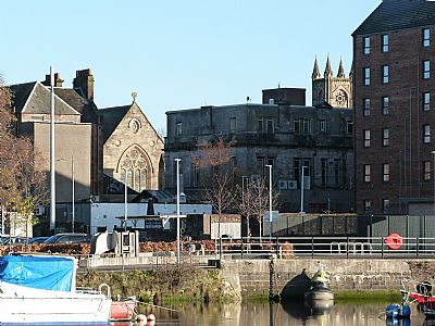
Sometimes looking back to an area from beyond illustrates it context better. This is a view from Levengrove Park and Woodyard Road. The Leven is in front with a few boats just off the quayside. You can see the gabled facade of ST AUGUSTINES CHURCH, HIGH STREET, DUMBARTON to the left and the tower of RIVERSIDE PARISH CHURCH, HIGH STREET, DUMBARTON to the right. Unfortunately most of the businesses facing the High Street turn their dowdy sometimes messy rears towards this viewpoint.
MACPHAIL, I. M. M. A SHORT HISTORY OF DUMBARTONSHIRE : The Lennox Herald, Dumbarton. 1963.
NATIONAL LIBRARY OF SCOTLAND : MAPS :
Mapmaker: Wood, John, ca. 1780-1847. Title: Plan of Dumbarton. Date: 1818. https://maps.nls.uk/view/74400020
Dumbartonshire Sheet XXII.NW. Date revised: 1896, Date Published: 1899 https://maps.nls.uk/view/75498375
and Dumbartonshire Sheet XXII.SW. Date revised: 1896, Date Published: 1899. https://maps.nls.uk/view/75498381
WIKIPEDIA : https://en.wikipedia.org/wiki/Siege_of_Dumbarton
