
A CHANGING DUNBARTONSHIRE
We talk about West Dunbartonshire as a region, a council authority area, even a county. But over the years this has altered. It is worth contemplating this when we look at the features within what we now know under this title.
THE LENNOX : A look at Wiki tells us :
The Lennox (Scottish Gaelic: Leamhnachd, pronounced [ˈʎãũnəxk]) is a region of Scotland centred on The Vale of Leven, including its great loch: Loch Lomond.
The Gaelic name of the river is Leamhn, meaning the smooth stream, which anglicises to Leven (as Gaelic mh is spirantised). The surrounding area is the field of the smooth stream - Leamhnachd in Gaelic; this was originally anglicised as Levenauchen / Levenachs, then softened into Levenax / Lennax, and eventually the area was known simply as Lennox.
Lennox was not one of the so-called seven ancient Provinces of Scotland, but formed as a province in the Middle Ages. The district embraced the whole of the ancient sheriffdom of Dumbarton: the parishes of Rosneath, Arrochar, Row, Luss, Cardross, Bonhill, Dumbarton, Kilmaronock, New Kilpatrick, Old Kilpatrick, Baldernock, Buchanan, Drymen, Killearn, Balfron, Fintry, and Strathblane, with Campsie and Kilsyth, being all within the bounds ruled over by the Earls of Lennox.
This is very significant when you visit Dumbarton Castle on the confluence of the River Leven with the Clyde.
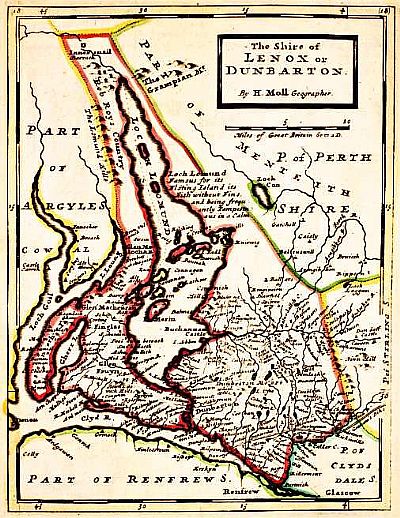
This is a map of "The Shire of Lenox of Dumbarton" by Herman Moll dated 1732. You can see that it included Bute to the west and Kippen to the east. What became Dunbartonshire is in red. Yellow is of the Parish of Stirling Shire. Pale blue is the Parish of Clydesdale Shire. Green to the north is the Parish of Perth Shire. Green to the south is Part of Renfrew Shire. NLS © as ref below. To see this map in more detail click the link NLS below.
NATIONAL LIBRARY OF SCOTLAND : MAPS : Mapmaker: Moll, Herman, d. 1732. Title: The Shire of Lenox [i.e. Lennox] or Dunbarton. Date: 1745. https://maps.nls.uk/view/00000290
A VISION OF BRITAIN THROUGH TIME : This website gives statistics over time for such subjects as population changs.https://www.visionofbritain.org.uk/place/16890
WIKIPEDIA : https://en.wikipedia.org/wiki/The_Lennox
DUNBARTONSHIRE
The area was subsequently altered and formalised into Dunbartonshire and again we turn to Wiki :
Dunbartonshire (Scottish Gaelic: Siorrachd Dhùn Breatann[1]) or the County of Dumbarton is a historic county, lieutenancy area and registration county in the west central Lowlands of Scotland lying to the north of the River Clyde. Dunbartonshire borders Perthshire to the north, Stirlingshire to the east, Lanarkshire and Renfrewshire to the south, and Argyllshire to the west. The boundaries with Lanarkshire and Stirlingshire are split in two owing to the existence of an exclave around Cumbernauld (see below).
Prior to 1975, the county was also used for local government with its own county council, its administrative centre being at the town of Dumbarton. Under the 1973 Local Government (Scotland) Act, the county council was abolished and administration was transferred to the newly formed Strathclyde council region and Dunbarton District Council. On further reorganisation of local government in 1996, two new unitary council areas of East Dunbartonshire and West Dunbartonshire were created.
A "shire" is a historic subdivision of Scotland established in the Middle Ages for judicial purposes; a territory over which a sheriff had jurisdiction. "Dumbarton" comes from Scottish Gaelic ie Dùn Breatann or Dùn Breatainn meaning '"fort of the Britons". There are many other hills once identified as forts or defensive positions around Scotland that are known as "duns", usually with that word as a prefix. Common use or pronunciation and spelling wavered in the early years of formal adminsitration between "dun-" and "dum", but they mean the same thing and we have inherited the latter in the name.
Map showing West Dunbartonshire from Kilcreggan in the west to Cumbernauld in the east.
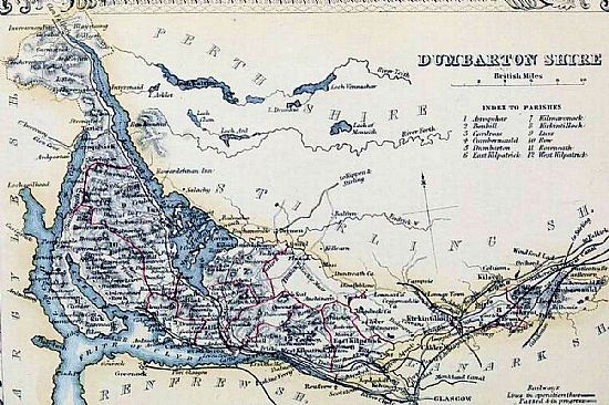
WIKIMEDIA COMMONS : DUMBARTONSHIRE Civil Parish map. The Imperial gazetteer of Scotland. Vol.I. by Rev. John Marius Wilson. https://archive.org/stream/imperialgazettee01wils#page/n531/mod / https://commons.wikimedia.org/w/index.php?curid=26673422
https://en.wikipedia.org/wiki/Dunbartonshire
WEST DUNBARTONSHIRE
So West Dunbartonshire as we know it today is a fairly recent designation : from 1996. For the purposes of this website the focus is within the official local authority area, but for some topics that we discuss, these have been stretched a little beyond that for historical or topographical reasons. Features such as the yairs at Ardoch, for example, would have provided a source of fresh fish for Dumbarton so are entwined in the town's story.
The National Records for Scotland show a large range of statistics and projections for West Dunbartonshire's population such as birth rates, life expectancy, marriages etc. An assessment of the overall population of the area and its fluctuations, for instance, makes one wonder why this occurs. It states :
On 30 June 2021, the population of West Dunbartonshire was 87,790. This is a decrease of 0.6% from 88,340 in 2020. Over the same period, the population of Scotland increased by 0.3%.
Are these natural demographic trends or does the availablity of housing have an affect?
https://en.wikipedia.org/wiki/West_Dunbartonshire
THE FIRST OR "GREAT" REFORM ACT OF 1832
The First or 'Great' Reform Act of 1832 granted extra seats in the House of Commons to larger towns and cities that had expanded particularly during the Industrial Revolution. It took away seats from those with a very small population – the so-called 'rotten boroughs' in England. The Act also expanded the electorate from 4,239 in Scotland in the 1820s to over 65,000 after 1832. This 16-fold expansion also increased the Scottish burgh representation in Parliament from 15 seats to 22, and established 'parliamentary burghs' (such as Greenock and Paisley). Some older royal burghs, such as Aberdeen, Dundee and Perth, were given a Member of Parliament for the first time, while Glasgow and Edinburgh were each given two MPs. [National Library of Scotland : Maps].
This map was compiled to assess the representational requirements of Dumbarton in 1832 as part of the Great Reform Act. NLS © as ref below.
Mapmaker: Great Britain. Parliament. House of Commons.
Title: Dumbarton
Date: 1832. https://maps.nls.uk/view/74491839
LOCAL AUTHORITY BOUNDARIES AND COUNCIL WARDS
The boundaries of West Dunbartonshire and its wards are shown below.
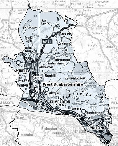
This map of the Local Authority area of West Dunbartonshire comes from the Scottish Government.
This map shows the overall extent of West Dunbartonshire. Within that are the various constituencies. You will notice the boundary to the south running midway along the Clyde. To the east it touches East Dunbartonshire and a part of Glasgow. To the west it touches Argyll and Bute. To the north it does a strange wriggle amongst the islands of Loch Lomond taking in Inchmurrin, but not Inchcailloch, yet curiously reaching up between Inchmoan and Inch Cruin. Why?
SCOTTISH GOVERNMENT : https://www.gov.scot/publications/local-authority-maps-of-scotland/
UK GOVERNMENT : https://members.parliament.uk/constituency/4495/location
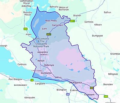
LOCH LOMOND AND THE TROSSACHS NATIONAL PARK
This is perhaps Scotland's greatest national asset. A vast expanse of water overlooked by the regal Ben Lomond. Nature and natural beauty recognises no political or local authority boundaries. When this became a National Park, it was instituted under the Loch Lomond & The Trossachs National Park Authority. That has its own governance such as its Planning Department, yet overlaps parts of West Dunbartonshire as well as Argyll and Bute and Stirling. You will therefore find the island of Inchmurrin, for instance within both West Dunbartonshire and the Loch Lomond & The Trossachs National Park with different yet complementary roles.
LOCH LOMOND AND THE TROSSACHS NATIONAL PARK : https://www.lochlomond-trossachs.org/
