
LOCH HUMPHREY, Kilpatrick Hills.
ACCESS : A fairly long walk mainly up a gravel road. See below for the route.
///strumming.unravel.robots Start of walk up road.
The walk up to Loch Humphrey provides us with magnificent views of the Clyde and beyond. The best place to start is by driving up from Old Kilpatrick along Station Road. Go under the A82 (there is no direct access) and park in the carpark just beyond the pump station. Do not attempt to drive further as the road only servces private properties from this point on. From this point on you will need to walk although off-road cyclists enjoy the route too. As the road sweeps westwards, you will find a branch road that takes you up the hill.
A great time to go is towards the end of the day. The sunsets seen from this vantage point can be spectacular, but be very sure that you time it correctly or you could find yourself coming home in the dark. The route is easy, but misleadingly long.
The track up is used for forestry and the usual precautions apply. Access by other vehicles is restricted. It is fished mainly for perch and occasional trout by members of the Bearsden Angling Club, who have a boat and a boatshed at the loch.
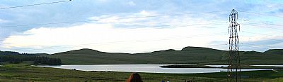
Loch Humphrey has a large catchment area of which Black Burn is the main source. When you reach it you will see the dam wall and overflow sluice. This flows into the Loch Humphrey Burn.
A cup and ring marked stone is across the fence to the west (NS 45699 75400) and there is a chambered cairn nearby towards the sheelfold (NS 45651 75311). Surpirinsgly there is a WWII bomb crater a little further west (NS 45503 75613), possibly from jettisoned ordnance of a returning German plane.


The walk up has some great views of the Clyde and surrounding areas.

Time your walk well. As the sky dims the view is lit up by thousands of lights. but remember that the path down is long.

CANMORE : Bomb crater record https://canmore.org.uk/site/353365/old-kilpatrick-and-dumbarton ; Chambered cairn https://canmore.org.uk/site/363981/boglairoch ; Cup and ring marked stones https://canmore.org.uk/site/43240/boglairoch.
PLOTAROUTE website : https://www.plotaroute.com/route/613053 This clearly shows the route on a map.
WALKHIGHLANDS website : https://www.walkhighlands.co.uk/Forum/viewtopic.php?t=53501
