
BOWLING HARBOUR : CANAL BASIN, Forth and Clyde Canal.
The restored railway bridge above is now known as the Bowline and provides through routes for cyclists and walkers as well as vantage points for visitors.
NOTE : Some clarity is required as to what is called what here. Just below this canal basin area is the larger harbour that used to serve sea going vessels on the Clyde. It was complementary to the Forth and Clyde Canal, but has long since become silted and unusable. Common usage now refers to this basin on the canal as "Bowling Harbour", although some maps, such as PastMap, use the term "Canal House Basin". Other sources even refer to it as "The Canal Company's Basin",or perhaps clarify which is which by "inner" or "outer" basin. In a way they are each parts of the same harbour complex anyway, but for this discussion we are looking at the canal basin at the end of the canal. And this too is in two parts, the lower and upper basins.
ACCESS : Easy access by car, cycle or on foot. There is parking nearby. Visitors should keep to the carpark which is towards the where the canal barges are tied up - turn left when you arrive at the canal. There is also a larger carpark, considered an "overflow carpark" right at the main road. Choose this first if you suspect that the area will be busy such as when there are events on. [Do not drive down to the main basin unless you are involved with the boating there]. Cyclists may find themselves passing by as they use the canalside towpath and old railway route as part of the NCN 754. The cycle way across the old railway bridge has ramps for access to the towpath at the canal level where there is sustainance and a bike shop. Care is required on the canal, basin edges and on the locks.
B listed.
///easily.quiet.librarian This is the point at which you arrive at the canal basin complex.
This is the western end of the Forth and Clyde Canal. A fascinating place. There is the basin itself connected by locks just above the Clyde and a wide section of canal above another lock. Both are utilised by boats for mooring.
A variety of craft are moored here; some permanently. You may find a canal boat or a yacht making its way across the central belt from the Forth to the Clyde. Perhaps you will see the scaled down replica Clyde Puffer, named appropriately "the Wee Spark". The Vital Spark is a fictional Clyde puffer, created by Scottish writer Neil Munro. As its captain, the redoubtable Para Handy, often says: "the smertest boat in the coastin' tred". This Wee version plays tribute.
This end of the canal is entwined with the old railway viaduct arches with its SWING BRIDGE above (described separately). As you approach down the ramped road you will first see the upper section of canal. From there you can pass down under the viaduct arches to the lower basin.
Some of the arches have been infilled as shops and other facilities. Those at the upper level include a cycle shop and a cafe.
The foot and cycle way leads across a drawbridge, this type otherwise known as a bascule bridge. It is made of timber and iron and operated by an iron wheel and cog mechanism. This and one in Old Kilpatrick are the last to remain along the Forth and Clyde Canal. Both are listed B.
Two houses sit alongside the basin and canal. The one at the basin is the old CUSTOMS HOUSE and that a little higher up on the canal and above a lock is Helenslea, originally the LOCK KEEPERS HOUSE. Each of these is discussed separately. [Now private]. The basin itself is listed B. This includes all of the infrastructure. A small simple little structure near the modern hoist must not be overlooked. This is the late 19th century lock keeper's bothy. Its function was to provide shelter and look out accommodation for the lock keeper. It is listed separately - also B.
The locks have been restored and are in working condition. They are fascinating to watch in action effectively lowering or raising the water and craft within them. Naturally the water is actually constantly flowing in from uprstream and is then controlled by the lock gates. It is possible to walk over any closed lock, but care is necessary, particularly with children or dogs.

The lower basin.

The lower basin and the Wee Spark.

The upper basin.
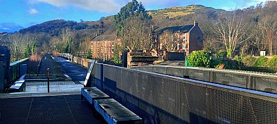
The Bowline created from the restored railway bridge. It is now a cyclist and walker through route and has vantage points down to the canal basins and beyond. There are also some interesting information boards.

And below the Bowline bridge are shops such as a cafe and bike centre.
CLYDE TO CALEDONIA website : https://clydetocaledonia.blogspot.com/p/journey.html
CLYDE WATERFRONT website : http://www.clydewaterfront.com/clyde-heritage/bowling-harbour--old-kilpatrick/bowling-harbour
GEOGRAPH.ORG : https://m.geograph.org.uk/photo/6403350; https://m.geograph.org.uk/photo/2673471
LIVING ON WATER website : http://www.livingonwater.co.uk/index.php/locations/show_location/30#:~:text=Bowling%20Basin%20is%20the%20western%20gateway%20of%20the,destination%20with%20a%20new%20cafe%20and%20shops%20planned.
PASTMAP : https://www.pastmap.org.uk/map
SCOTTISH CANALS : https://www.scottishcanals.co.uk/activities/cycling/forth-clyde-canal/glasgow-to-bowling/
WEST DUNBARTONSHIRE HERITAGE TRAIL : OLD KILPATRICK, BOWLING AND MILTON : https://www.west-dunbarton.gov.uk/media/2619074/ok_booklet.pdf
WIKIPEDIA : https://en.wikipedia.org/wiki/Bowling,_West_Dunbartonshire (And this had more on the Vital Spark - https://en.wikipedia.org/wiki/Vital_Spark).
