
STONEYMOLLAN and the COFFIN ROAD, near Balloch.
ACCESS : Good walk, some over rough ground. Sometimes used by off road cyclists. Start and end points are discussed below. Total route including Cardross end = 7.5 km. Part of John Muir Way.
///icicles.rugs.deploying Turn-off from Old Luss Road up Lower Stoney Molan Road. Park in Old Luss Road.
///ejects.tinny.pyramid Turn-off at the A82 roundabout. Park further up.
Stoneymollan is actually a track. It is a pleasant walk up the hill to the west of the A82.
There are two starting points in this vicinity.
It is possible to park just off the Stoneymollan Roundabout on Upper Stoneymollan Road. To do this go to the west side where there is a small tarred road. When parking, remember to allow for passing of farm vehicles and private cars. Choose a place a little further up.
The alternative is to leave Balloch on foot. Follow Old Luss Road past the Princess Rose restaurant and look for the small track just beyond the Lomond Woods Holiday Park. This is Lower Stonemollan Road. Walk up this. You will find a wooden bridge over the A82. Cross this and proceed up Upper Stoneymolland Road on the other side. This first section is a tarred road serving a B&B and Stoneymollan Farm. Note that you need to park in Old Luss Road, not up the smaller track.
When the tar runs out you will find the track that is usually referred simply as "Stoneymollan". And stony it is.
The track runs along the edge of farmland and you may encounter cattle here.
The track then runs all the way up the hillside, almost straight, through some trees and then onto muirland until it meets plantation forest. From here you will have great views across the Vale of Leven and northwards towards Ben Lomond.
While from here on it is beyond what is termed Stoneymollan, the track does not stop here, but proceeds across Darleith Muir in a wide arc until you reach the Red Road and from there, Darleith Road, leading into Cardross. It is quite possible to then take a train from Cardross and find your way back to Balloch.
This is an old coffin road that people would have used to carry their dead to be buried in the consecrated ground of St Mahew's Chapel on the Darleith Road leading into Cardross. Along the way you may find flat rocks or flat piles of stones. These were coffin rests on which to lay the coffins during such long difficult walks. These have since been disturbed, but you may recognise one or two. An early OS map refers to this track as the Cross Stone Road . There was evidently a stone cross on the route and marks on one of these rocks which is thought to be the base.
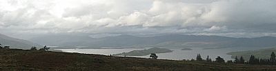
A view of Loch Lomond from the top.
HERITAGE PATHS website : http://www.heritagepaths.co.uk/pathdetails.php?path=62 and http://www.heritagepaths.co.uk/mapsearch.php?path=62#zoom=13&lat=55.9834&lon=-4.6298 This latter has a useful detailed map.
VIVIEN MARTON website : https://www.vivienmartin.scot/2018/06/13/old-ways-through-the-glens/
