
BOWLING SHIPYARD
ACCESS : This can be approached from the river side of Bowling Station. However it is not entirely safe. It should rather be viewed from the canal basin or from the footbridge over Bowling Station.
///vandalism.apple.chairing This is the crossing point over the railway footbridge and provides sufficient views of the shipyard.
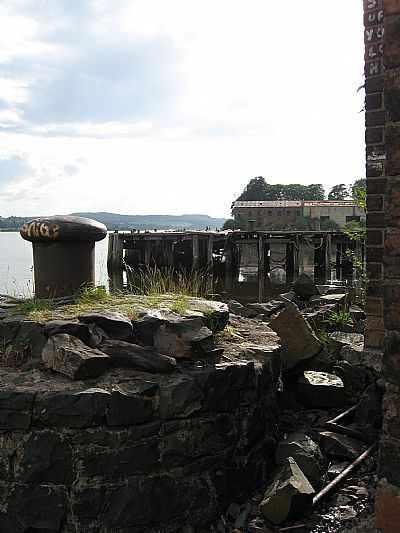
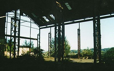
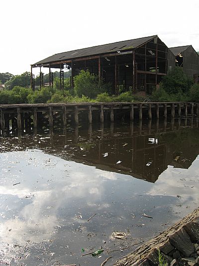
This shipbuilding yard was right next to Bowling Harbour. The remnants of the slipway, wooden jetty and the bases of buildings can be seen. It was somewhat smaller than the other shipyards within West Dunbartonshire, but nevertheless produced, serviced and repaired vessels.
Old maps show Frisky Hall. This was a popular inn, long since gone. It stood just above Frisky Slipway, both getting their names from the ferry service which ran from Frisky Wharf in Greenock. This land is where the shipyard was developed.
The shipyard had been established around 1800 by the McGill brothers. In 1851 they were taken over by James Scott and the firm became known as Scott and Sons.
Maps from 1897 show it had expanded and it is this development that can be made out today. The slipway became known as ‘Littlemill Slip Dock’ - a reference to the nearby Littlemill, better known as a distillery. (Also see LITTLEMILL DISTILLERY index.asp?pageid=718199).
Between 1800 and 1847 the shipyard produced about 40 ships. By the late 1840’s the McGill’s joined forces with James Scott to form Scott & McGill, which became Scott and Sons in 1851. Between 1851 and 1979 Scott’s built in excess of 450 vessels. Scott’s was incorporated as a limited liability company in 1958 and traded for the first time as Scott & Sons (Bowling) Ltd. [Alistair Baird].
Boats awaiting attention in the shipyard were kept in the adjacent Bowling Harbour.
That became Scott’s Shipbuilding & Engineering Co Ltd of Greenock and it later became part of the Scott Lithgow Group.
Shipbuilding at the yard ceased in 1979.
The following photographs were taken in 2007. They show a crumbling infrastructure. Most of that is now gone.
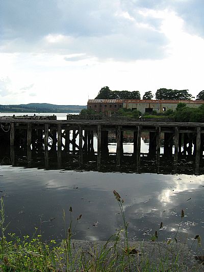
Looking across from the embankment of the main Bowling Harbour.
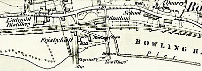
This OS map dates from 1860.
Reproduced with permission. NLS ©
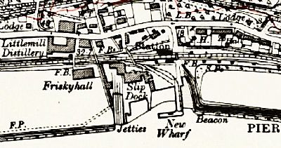
This OS map dates from 1914.
Reproduced with permission. NLS ©
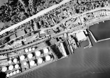
This air view was taken in 1973. You can cleary see the shipyard with Bowling Harbour to the right / east and fuel tanks to the left / west. The fuel tanks were established by ESSO, later becoming EXXON-Mobile. That area is currently the subject of redevelopment. Dunglass Castle is just out of sight to the left.
NCAP ©. See reference below.
ALISTRAIR BAIRD writing on Pat's Guide : Glasgow West End website : https://www.glasgowwestend.co.uk/scotts-of-bowling-history-of-the-clydeside-shipyard-by-alistair-baird/
CANMORE : https://canmore.org.uk/site/43397/bowling-shipyard
NATIONAL LIBRARY OF SCOTLAND (NLS). Maps reproduced with permission.
1860 map. Archive title : "Dumbartonshire, Sheet XXII (includes: Cardross; Dumbarton; Erskin... Survey date: 1860 , Publication date: 1864". https://maps.nls.uk/view/74426624
1914 map. Archive title : "Dumbartonshire Sheet nXXII (includes: Cardross; Dumbarton; Erskin... Date revised: 1914, Publication date: 1923". https://maps.nls.uk/view/75827402
NATIONAL COLLECTION OF AERIAL PHOTOGRAPHY : Reproduced with the permission of the National Collection of Aerial Photography. The archive record is 07 June 1973 Hill of Dun; Old Kilpatrick; DUNBARTONSHIRE; SCOTLAND Frame: 0228
RAILSCOT : https://www.railscot.co.uk/locations/F/Frisky_Wharf/
WEST DUNBARTONSHIRE COUNCIL website : https://www.west-dunbarton.gov.uk/leisure-parks-events/museums-and-galleries/collections/shipbuilding/shipbuilding-bowling/
WEST DUNBARTONSHIRE HERITAGE TRAIL : OLD KILPATRICK, BOWLING AND MILTON : https://www.west-dunbarton.gov.uk/media/2619074/ok_booklet.pdf
WOSAS : https://www.wosas.net/wosas_site.php?id=53703
