
TURKEY RED : 4 - LEVENFIELD BLEACH AND PRINT WORKS
NOTE : This works became merged with the Croftengea Works immediately downstream and that in turn became known as the Alexandria Works. The lade identified here becomes common to that too. It should notbe confused with the Levenbank works on the east side of the river.
Also see TEXTILE WORKS LADES and RAILWAYS
ACCESS : The inflow of the lade is at the point that the towpath and roadway near the baotclubs and barrage merge. The lade can be followed with varying degrees of direct access for its length until it reaches the current distillery.
///engineers.tuned.degree The lade inflow marked A on the map.
///flank.growth.joins The lade where it reaches the distillery and marked B on the map.
For the STUCKIE BRIDGE which runs over the lade and what was the enclosed site of this works see STUCKIE BRIDGE
This works had a long lade, either in order to get the best flow from the bend in the Leven further up or with ambitions for expansion. That lade now goes under Loch Lomond Distillery. Note that the distillery is large and this works was at one end while Croftengea Works was at the other.
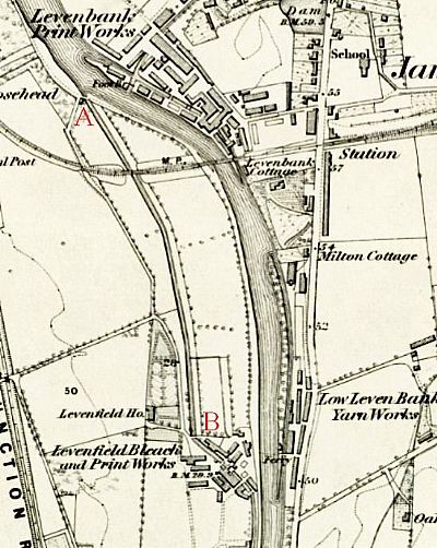
The lade comes in at A and exits at B. The tow path passes over the incoming lade at A where a combination of control sluice and grating can be seen. It then leads down to and under Strone Road in the current industrial area and up to what is now the Loch Lomond Distillery. You can make out where it then continued through these works and on parallel to the Leven to the Croftengea Works.
NLS ©
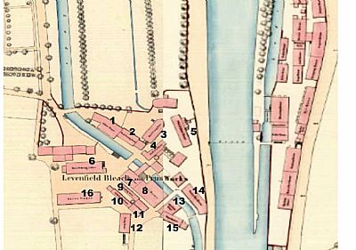
This is a composite of two maps dated 1859. Note how the lade bends as it enters this works before turning again downstream heading for the Croftengea Works. Across the Leven is the Low Levenbank Yarn Works. ©
-
COLOUR HOUSE
-
BLOCK PRINTING HOUSE
-
BLOCK PRINTING HOUSE
-
SHELL CHEST HOUSE
-
OLD COLOUR STORE and boiler
-
BLOCK PRINTING HOUSE
-
CYLINDER HOUSE
-
DYE HOUSE
-
PADDING STOVE
-
CYLINDER SHELL ROOM
-
STEAM BOILERS
-
DRYING HOUSE
-
STARCHING HOUSE
-
FANCY DYE HOUSE
-
WAREHOUSE
-
STOVE HOUSE
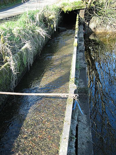
The lade begins here. Water from the Leven passes under this iron culvert. The culvert is constantly flowing with ground drainage water from the area a little further westwards. It appears that this dual system was intended to separate the clean Leven water from the often soiled ground water. The latter then joins the Leven flow anyway just across from this point. Under the culvert and the towpath are stone vaulted support arches.

Close to the towpath is this double structure which appears to have been to control the flow into the lade.
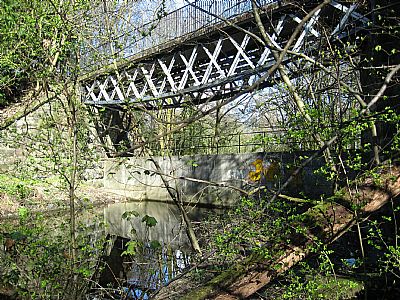
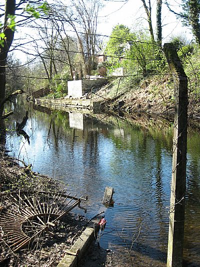
This bridge over the lade is the pair with the Stuckie Bridge over the Leven - both part of an unrelated rail link. Below the bridge is a modern concrete barrier to stop water flow. Although there are some small outlets at the base, the flow is now effectively zero. And this creates a challenge. It is a lade without a beginning or an end. It has gone completely stagnant.
The old map seems to suggest that the Stuckie Bridge and its embankment went through the works property. This is confirmed by the low stone wall north of the bridge. That area to the south of the bridge is currently (mid-2024) being cleared for commercial development. It had become very wooded and remain largely under water much of the year.
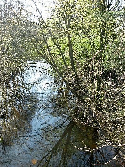
The lade is now quite overgrown.
A few houses back onto the lade. A vew of the water is marred by neglect, misuse and lack of resolution of its flow or at least water quality. A planning opportunity that has been missed. There is so little left of our once amazing textile industry. The lades are one such feature. Other than a short remaining section at Dalquhurn, this is the most significant feature.
Looking through the records of the various textile works histories and extant features, you will notice that there are in fact several segments of lade still to be seen, This one though is by far the most significant. It may not flow properly anymore, but that surely can be remedies at some time.
COLOURING THE NATION - Wordpress - Project run by the University of Edinburgh and the National Museums Scotland : https://colouringthenation.wordpress.com/turkey-red-in-scotland/
NATIONAL LIBRARY OF SCOTLAND (NLS) : The maps here are reproduced with the permission of the National Library of Scotland.
1860 : Archive title : " Dumbartonshire, Sheet XVIII (includes: Bonhill; Dumbarton; Kilmar... Survey date: 1860 , Publication date: 1864". https://maps.nls.uk/view/74426619
1914 : Archive title : "Dumbartonshire Sheet nXVIII (includes: Bonhill; Cardross; Dumbart. Date revised: 1914, Publication date: 1923" : https://maps.nls.uk/view/75827346
NATIONAL MUSEUMS SCOLAND : https://blog.nms.ac.uk/2012/06/22/turkey-red-a-study-in-scarlet/
VALE OF LEVEN PROJECT website : http://www.valeofleven.org.uk/levenbridges.html
and http://www.valeofleven.org.uk/valeindustry3.html
and Alexandria - Sheet XVIII.10.1. Surveyed: [1859],
WEST DUNBARTONSHIRE COUNCIL : Textile Industry in the Vale of Leven. https://www.west-dunbarton.gov.uk/leisure-parks-events/museums-and-galleries/collections/industry/textiles-and-mills/ and The River Leven Heritage Trail . https://www.west-dunbarton.gov.uk/media/2619077/vale_of_leven.pdf
WIKIPEDIA : https://en.wikipedia.org/wiki/Turkey_red
