
TEXTILE WORKS, LADES and RAILWAYS
Remnants of a once thriving and proud industry within the Vale of Leven.
In this section we highlight some features of the Vale's once proud and vibrant industrial era that can still be found. For out purposes here we concentrate on remnants of the railways that served the textile works showing how they also ran southwards to Dumbarton and eastwards to Stirling. We also highlight the remnants of the largest lade serving the textiles works, in fact the only one that remains intact.
These features form a nucleus of extant industrial history manifested within a fascinating environment of water, steel, stone and woodland. There needs to be a concerted effort to conserve it. By this it is not meant that it become a reinstated historic environment. But as it is all within a pleasant largely natural setting with plants, wildlife and walks, it should be improved and highlighted with key features having signage and pathways improved and made safer where there are impediments such as a steep slippery slope, trip hazards of steel and routes and the edge of the gulley.
As of mid-January 2025, we note that some mature trees have been cut down just inside the stone wall just upstream from the VOLDAC clubhouse. This adds to the damage to trees within the woods by miscreants during drinking boats.
The lade and bridges in particular, need to be protected against inappropriate development, infilling and alteration.
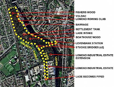
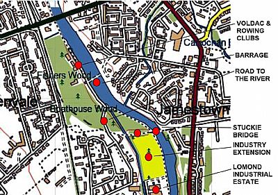
The areas highlighted in yellow are discussed in this section. They include Fishers Wood / Boathouse Wood with the Stuckie Bridge railway routes running through them and the major lade that runs southwards. Google Earth. ©
In this map of 1898 we see two railways, somewhat merged over parts of their routes. (The colours alternate across those sections). That in dark blue heading off to Stirling via Port of Menteith. The red heading to Balloch. Both of these served the industries of the Vale of Leven. You can see all the textile works and also the Alexandria Gas Works. And also the pier at Loch Lomond. This is an extract from one of two sheets entitled Official railway map of the Edinburgh and Glasgow district. West sheet. The loch and River Leven have been over coloured in light blue, the original colour on the map being indistinct. NLS © as link below.
LEVENFIELD / CROFTENGEA WORKS on the west bank and the LEVENBANK PRINT WORKS on the east bank. Common to both was the THE STUCKIE BRIDGE
Lades are much the same as canals, yet more than just channels. Lades are used to direct water into an industry whereas canals are built for water borne transport.
Each of the textile works had its essential supply of fresh water. The very reason that they were all located along or very close to the River Leven was that the water supply was reliable and very clean. You can see the remnants of most of the shorter lades along the river, some hidden by vegetation; some blocked by stone gambions to deflect the flow away from more more recent develoments. Lades could also be used to drive machinery; watermills etc.
THE RAILWAYS & THE STUCKIE BRIDGE
Today the railways within the Vale of Leven is reduced to just one line between Dalreoch and Balloch Stations. We refer to the railways elsewhere as well on this website, but focus here, on that of the Vale of Leven industries. Each of the textile works as well as the Argyll Motor works had access to a rail connection. In fact there was a substantial network of railway lines around the Vale and these crossed the Leven over the Stuckie Bridge.
The north / south line was designated the N.B.R. & C.R. - Dumbarton and Balloch Joint Line, (Northern British Railway cooperating with the Caledonian Railway, while that heading off to the north east towards Stirling was the Forth and Clyde Junction Railway. That sweeping curve crossed across the Stuckie Bridge where there was a siding serving the Levenbank Print Works. For more on those works see TURKEY RED : 2 - LEVENBANK PRINT WORKS. That siding is discussed below as the Levenbank railway siding.
It is of interest to see this combined railway service down the Vale serving the Cordale Works too. TURKEY RED : 11 - CORDALE PRINT WORKS
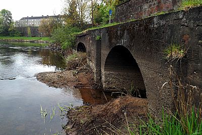
For more on the Stuckie Bridge see STUCKIE BRIDGE. It was built as a railway bridge. The line it carried was not directly linked to the two textile works described here, but if you follow the lines on the map below, you will see that they connect up further on.
We return to the railways within this area further down below, but for now let us concentrate on the lades as they represent the remnants of the textile industries that define this environment.
[The other works in the Vale had links with the railway too].
LEVENFIELD / CROFTENGEA WORKS LADE
There is one lade though that remains intact, that of the the Levenfield Print and Bleach Works / Croftengea Print Works. This section focusses on the lade, which served both works, but should be read in conjunction with that on each of them. TURKEY RED : 4 - LEVENFIELD BLEACH AND PRINT WORKS & TURKEY RED : 5 - CROFTENGEA / ALEXANDRIA WORKS.
Circumstance has integrated this lade with the Stuckie Bridge STUCKIE BRIDGE which was built as a viaduct for the Forth and Clyde Junction Railway. That was quite independent, yet had an impact on the lade below.
Today it flows, if that is the right term, through what is effectively part of Fishers Wood, Lomond Inudstrial Estate and the Lomond Distillery premises. Within the latter it is generally underground, a pair of arge vaulted pipes or tunnels. Within the industrial estate it is protected from Strone Road by an embankment with mature trees, yet the extension has until 2024 been well wooded too, It appears from old maps that that area was used by the works as a yard, the trees having sprung up in later years. Both this and modern Strone Road are prone to annual flooding, so this is unlikely to have been very practical (a challenge for the new owner of this land).
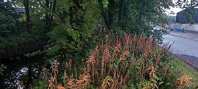
The lade where it flows through the woods is very attractive. Until clearing of the woods south of the Stuckie Bridge in 2024 this section was too, a haven and breeding place for mallard and moorhens. The trees are home to a great variety of smaller birdds. Kingfishers dart along its length. Squirrels, rabbits and even some deer frequented it. Several attractive houses look out onto its watercourse and trees from Heather Avenue. Their ambience is now somewhat lost. It needs to be noted that this land - NOT the lade - has been designated as industrial opportunity in the Local Development Plan (LDP) for the last 4 years. Its development cannot be disputed, but criticism is raised about the lack of suitable buffer zone or interface between the water course and woods and any new industry. Hopefully this will still occur.
So this lade remains almost intact and many of the structures from the Croftengea Works still exist within the Lomond Distillery premises.
This means that we have here a very important combination of structures of local industrial heritage that must be preserved.
West Dunbartonshire identifies a number of designated Conservation Areas and listed buildings, but it does not do so to other features of important historical and heritage significance. This is one combination if features that should be so covered.
Elsewhere all remnants of similar industries have been all but obliterated.
None of the buildings within the Lomond Distillery premises that survive in some form from the Croftengea works are listed. This is understandable as they are not of significant architectural value, are not accessible to the public and need to be adapted over time to meet the needs if their current usage. While it would be sad to see them eventually disappear or be drastically altered, they remain private property subject to commercial criteria.
The lade though, by strong contrast, is mainly accessible and an integral part, by assimilation, of the natural environment. In preservation terms it should be given priority.
What follows are several photographs recording this lade.
This is a sluice channel that passes over the entrance to the lade. It is otherwise unrelated, diverting stormwater past it. (It was felt essential to avoid potentially dirty water from coming into the works via the lade so this sluice takes that over the lade entrance. Also see FISHERS WOOD & BOATHOUSE WOODS which had a water purification works).

Very close to the lade inlet is this structure comprising a flow control gate and alongside that a narrow access bridge for those involved.
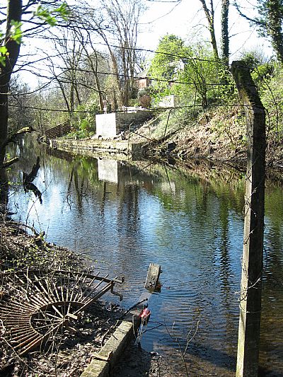
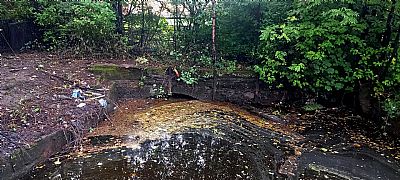
 The lade within the woods looking upstream. The stone walls are higher at this end, very close to the inlet from the Leven.
Iron posts can be seen, evidently used to support timber siding from where the stonework drops in height. That timber has long since rotted away. Also just visible (beyond the white bucket) are slots in the stone wall to take heavy timber "sluice gates".
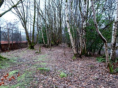
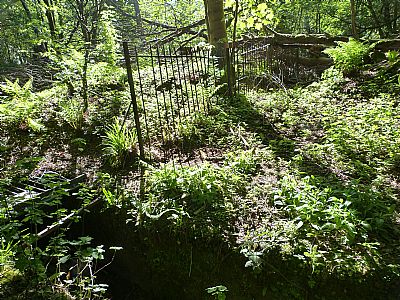
In this section north / upstream of the Stuckie Bridge you can see the stone walls of the lade within the woods. The banks have subsided and the lade has become very silted.
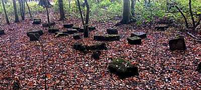
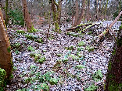
Nearby in the woods are these dressed stones. They do not appear to have been from a building or the sides of the lade, but may have been intended for the boundary wall alongside the towpath that abruptly stops short; presumably intended to have been extended one day.
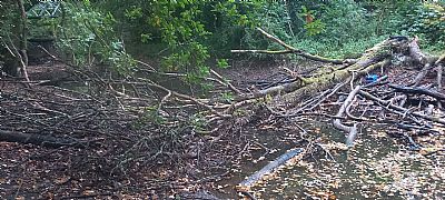
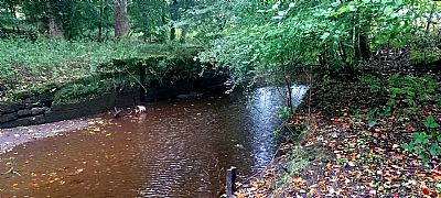
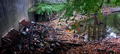
A natural occurrence. A large tree has fallen across the lade, further inhibiting flow. All along its length it has faced both natural silting as the banks have subsided and debris dumped by the public.
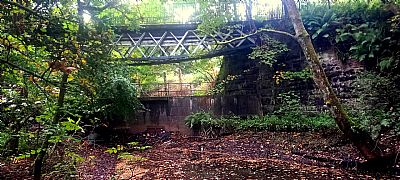
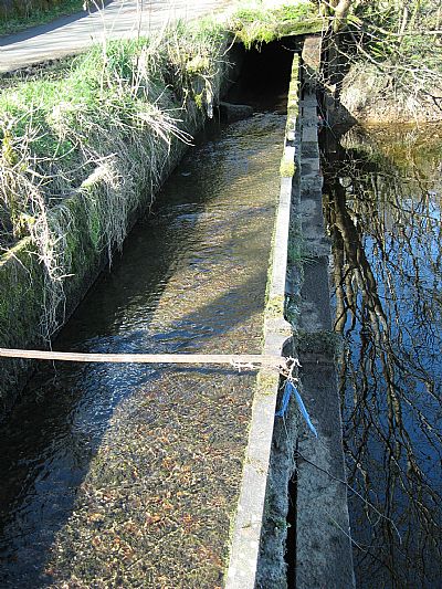
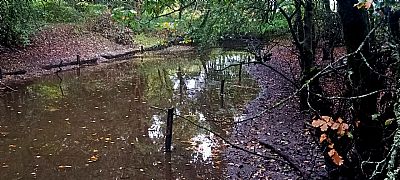
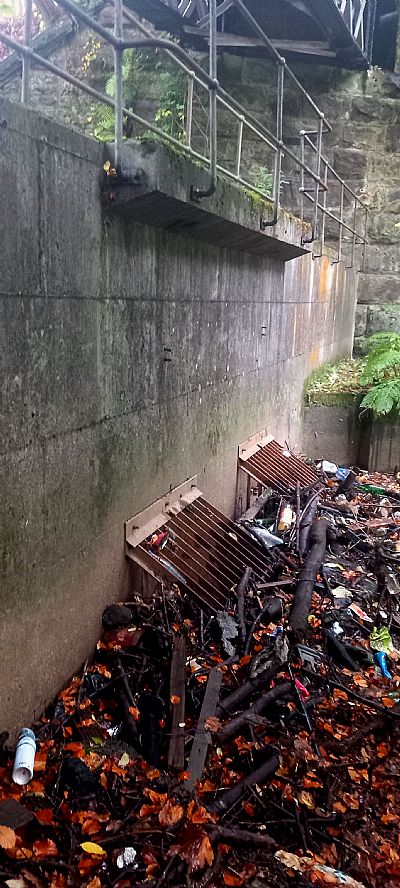
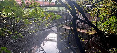
This is the section of the Stuckie Bridge that goes over the lade. The buttresses are substantial and between them and below the bridge is a concrete structure built to control flow; a weir. Within it are control valves which are accessed from above. There is even a walkway with a safety railing. That weir would have ensured a level of water within the lade for the works further down. Sometimes though that level would be too great and the valves would be opened to release it. That is still done today when the area floods further down.
Here you can see two valves with heavy metal gratings to hinder debris entering the lade beyond. Modern muck has almost, but not quite blocked them. Note that these pictures were taken when the Leven was at low level. Several times a year the flow was much hgher. Water was let in to the next section of lade and held there as a reservoir.
A similar view, but showing more of the wall above.
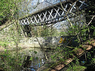
A closer view of the Stuckie Bridge and control weir. Note that the bridge is actually in two parts. One over the river and this one over the lade.
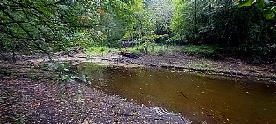
Downstream from the Stuckie Bridge it is faced by some housing; In the foreground is part of a semi-circular barrier such as used over a pipe or lade edge that has long since disapeared. And further on we see how a home owner has attempted to shore up the lade bank and has created a built up terrace.
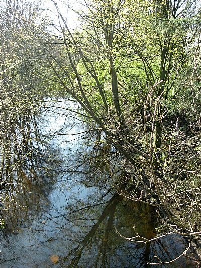
The lade is generally overgrown, but is frequented by both water and forest birds.
This picture shows the lade to the left and Strone Road to the right. You can see industrial units beyond the lade and alongside the road. A substantial berm was left between the lade and the road when the area was developed for modern light industry. This has become well wooded and has many flowering plants too. It is important that this approach is followed when developing the extension to the industrial area towards the Stuckie Bridge too. This ensures minimum disturbance to the lade walls and a buffer zone for the natural environment.
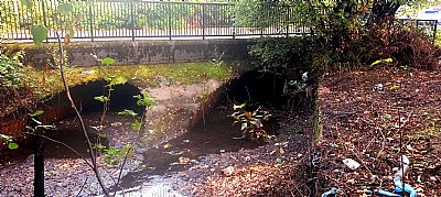
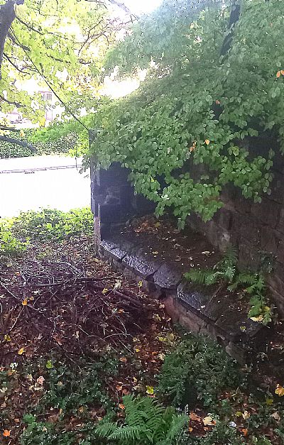
As it meets the road bridge at Strone Road it is impeded a bit by the vaulted tunnels.

The lade then passes through a pair of stone vaulted tunnels at the boundary to the Lomond Distillery at the point that it would have been the fence of the Crotengea Works. Although it is still flowing, this is badly impeded by the structure, silting and the large amount of debris dropped into it. This picture was taken in mid-2024 when an attempt had been made to clear it.
Where the lade meets Strone Road within the Lomond Industrial Estate. This is how it usually looks when the water level is higher.
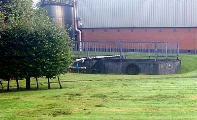
Once inside the boundary of Lomond Distillery that had been the Croftengea Works, it bends. At this point we see a complex of old and modern control walls. and mechanisms.
And then it disappears underground and below the buildings.
These tunnels exit back into the River Leven near the bottom of Alexander Street. But they do not take a straight course. There are two significant bends in them. Presumably when they were in full use, there was a regular attempt to keep them from silting. There are possibly some access points long since overed over and lost to view.
You can see that the water still flows, but there is a great deal of silt too. Cleaning out would be challenging. While the lade does reappear within the distillery premises, most of it is now covered over. Clearing out would have to be mainly by hand (if at all justified). There are heaving metal bars within these two tunnels to restrict access.
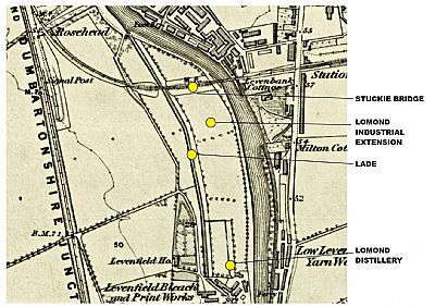
In this map of 1860 you can see the field (since grown over by trees) clearly demarcated with a buffer zone between it and the lade. The field boundary to the right is also that still defined by the stone wall. The labels indicate the features as they are today. The area shown as Lomond Industrial Extension was cleared in mid-2024. NLS ©
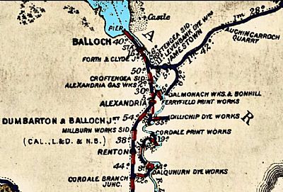
In this map of 1914 you can make quite a few railway lines that served the textile works and were linked with the main lines. Only the main ones relevant to our subject here are highlighted in yellow, but you can make out quite a few branching out to serve the various works. The River Leven has been overmarked in dark blue. The lade serving the Levenfield works through to the Croftengea Works is visible in paler blue. Also visible where the railway passes over the Stuckie Bridge is the Levenbank Print Works, now housing. © NLS
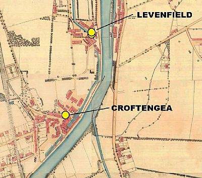
This map of 1859 obviously predates that above, but it is useful to compare the two depictions in this order. In this early one you can see that the Levenfield and Croftengea works are distintively separate with the lade passing through both of them. You can clearly see the way the lade bends to accommodate them, passing under some of the buildings and reemerging before disappearing again.
Much change has occurred in what is now the Lomond Distillery premises, but the lade tunnels still exist beneath them.
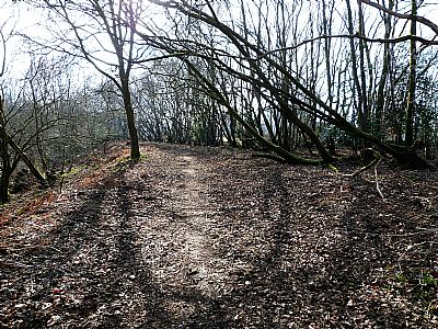
When you walk in Boatyard Wood (the section of woods that adjoins Fishers Wood, you may notice that some small trees appear to be roughly in an avenue. It is unlikely that they were planted this way, but more probably sprung like this in the freshly disturbed earth when the rails were eventually lifted.
JUNCTION OF THE FORTH AND CLYDE RAILWAY WITH THE CALEDONIAN AND DUMBARTONSHIRE RAILWAY WEST OF THE STUCKIE BRIDGE
As the railway from heading northwards towards Balloch it is met from the east from that roughly east - west heading towards Stirling. The arrangement is somewhat odd with the latter having to head across the Leven and then curve northwards before being able to connect with the former instead of forming a smooth through route. But this arrangement arose from the evolution of the local textile industries rather than a continuous rail network. After all these were two entirely separate rail companies at the time. The first map on this page shows how this was laid out.
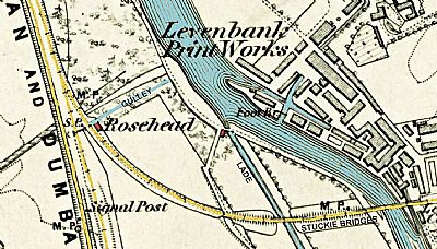
This is another view of the extract from the map of 1860. The two railways are highlighted in yellow. The Forth and Clyde Railway heads off eastwards and the Caledonian and Dumbartonshire Railway comes up from Dumbarton. The Stuckie Bridge over the Leven and the lade is down to the right. Note that as the line coming from over the Stuckie Bridge curves and heads north, it runs parallel to the Dumbarton - Balloch line for some distance. There is a level difference between them to accommodate. The current Balloch line runs much the same within this same shallow cutting. (There is also a short tail-end for shunting that ends just south of the words "Signal Post" - and out if view on the map. The lade itself is the straight line in blue leading sourwards. A narrower blue line is visible further up in what is now the junction between Boathouse Wood and Fishers Wood. This is a drainage gulley leading from the west towards the river (built before the settlement tanks). Near the junction of the two railways and adjacent that gulley are the remains of a small building. It is very small, but on this map is labled "Rosehead" ie a cottage. (Not to be confused with a house built later in Heather Avenue called Rosshead). The current road, an extension of Heather Avenue, runs down to the river and follows much the same route as seen here. NLS © as ref below.
If you look for remnants of those features today, you will see not only the River Leven, but the lade running through Boathouse Wood (the southern end of Fishers Wood). Look more closely and you will also see signs of the two railways that ran over the bridges.
This is the view of what looks like a planted avenue of trees. It is behind the formal games area at the end of Halkett Park. It is most likely that this "avenue" grew naturally like this when the railway line here was lifted and the soil was disturbed. This picture was taken in mid winter when the vegetation is less overgrown. It is much less obvious in summer.
Some of the trees came down or were tipped to odd angles during Storm Eowyn in January 2025.
This is more than just a pile of rocks alongside the above mentioned "avenue". This was a small building. Its location wedged between the two railway lines and the surrounding fence suggest that it may have housed someone to watch over the operation and merging of the two railways at this point. We can make it out in the 1860s map above. There it is labelled as "Rosehead" which suggests that it was a cottage or perhaps it simply had many roses planted around it in what is sometimes the railway tradition. You can even still see the iron paling fence that surrounded it.
The map also shows a small building where the lade flows off from the Leven. That is also where the predecessor of the current road down to the barrage and boat clubs was. There are no longer any firm signs of it, but it may explain some of the bits of stone and concrete that lie about the woods there.
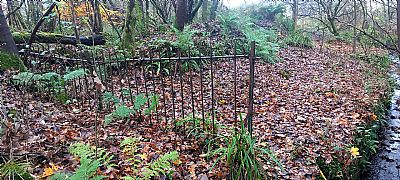
In this picture we are looking back from the path within Boathouse Wood over the gulley to the cottage ruins. Its metal palisade fencing is clearly visible. That drainage gulley can be seen in the map above. The fence continues across the gulley and some short spikey remnants of it where it has been cut down still form an impediment to walkers. Its arrangement suggests that the house and railway connection are related.
A similar view in spring.
THE LEVENBANK PRINT WORKS RAILWAY SIDING
We have focussed above on the Stuckie Bridge where it passes over both the Croftengea Lade and the River Leven. The Levenbank Print Works on the east bank tends to be forgotten as it is all replaced by modern housing, the riverbank being rebuilt along with the barrage.
But you can still see something of the railway siding in the form of the fences and gates to the works. The siding was built up to widen the level area here.
The retaining wall where the railway siding was widened.
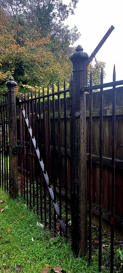
The fence and gate that led off from the railway siding to the works on the north side.
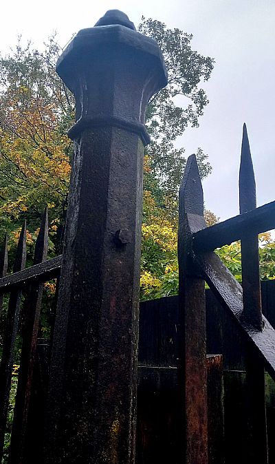
And gatepost.
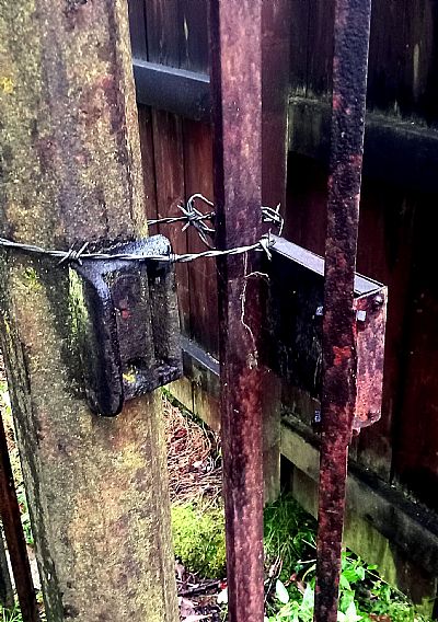
And lock.
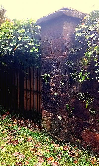
The fence meets the wall at this post.
The fence opposite also still remains, albeit modified. This side does not have spiked ends.
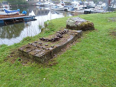
This concrete and iron structure sits on the riverbank just up from the VOLDAC clubhouse. It has probably been used as a mooring, but appears to be created from concrete railway sleepers. These have been connected together and there is a segment of heavy chain on it. While it is unknown quite what its original use was, we suspect that it formed a counterweight for heavy industrial plant nearby, such as a crane OR used as moorings against the strong current. WOSAS notes that two houseboats sunk alongside the riverbank here in 1931 and perhaps this was something to do with their recovery, which may explain they it is now here. (There is also a large retangular block of concrete with cast in steel rings on the other side of the path).
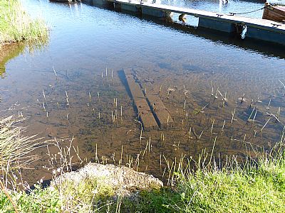
There is more such concrete in the water.
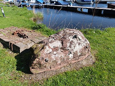
Even that large rock has remnants of iron fixings.
A VISION FOR THE FUTURE
To consider this in perspective, we need to see the overall context along with the Fishers Wood and Boatyard wood. At the moment the Stuckie Bridge is well used by walker and cyclists to cross the river and lade. It is both useful and an attractive route as it passes high amongst the trees and passes these two water courses. A great many people love the rich environment so formed, but unfortunately it seems that they are nevertheless up against the many who don't; those who mistreat it, leave it and the woodland walks covered in litter, the lade in particular left in a terrible state.
Ideally the lade needs to be cleared and reinstated as a water course. This is straight forward (with funding) where exposed, but could be very challenging within the distillery premises where it is largely underground. The combined Fishers Wood / Boathouse Wood and the exposed lade need to be preserved as one environmental entity for recreation and as a viable ecosystem.
This is a modern map annotated to show current features. As of mid-2024 moves have been started to incorporate the area shown in yellow as part of Lomond Industrial Estate. As indicated on the map above this one, the site does not meet the lade, but is set back from it. This should remain a green space as an environmental buffer and also to avoid disturbance to the lade banks. A similar buffer strip is essential along the embankment of the Stuckie Bridge.
NATIONAL LIBRARY OF SCOTLAND : MAPS : Dumbartonshire, Sheet XVIII. Survey date: 1860, Publication date: 1864. https://maps.nls.uk/view/74426619
and Official railway map of the Edinburgh and Glasgow district. West sheet. London : Railway Clearing House, 1898. https://maps.nls.uk/joins/5905.html
and Dumbartonshire Sheet nXVIII Date revised: 1914, Date Published: 1923 https://maps.nls.uk/view/75827346
WIKIPEDIA : https://en.wikipedia.org/wiki/Caledonian_and_Dumbartonshire_Junction_Railway
