
DALMUIR
Dalmuir has again regained something of its own specific character and identity after years since its main industry faded and its more assertive neighbour blurred their common edges. You can see that in the maps below, but before we turn to that lets discuss its origins.
Dalmuir was to become one of the Clyde's shipbuilding centres. To find out more about that see BEARDMORE SHIPYARD, DALMUIR.
Also see BEARDMORE SCULPTURE, DUMBARTON ROAD, DALMUIR; BEARDMORE HOUSE, DALMUIR, DALMUIR PARK, DALMUIR
Wikipedia tells us that The name is a lowland Scots derivation of the Gaelic meaning Big Field. The area was originally two separate villages with Dalmuir Shore joining with Clydebank in 1886 and Dalmuir Village in 1906, during a period of rapid industrialisation and expansion.
The area was initially accessed from the River Clyde via an old quay for loading and landing goods at Dalmuir Shore, the current location of the Golden Jubilee Hospital. Prior to 1790, Bridge Street ran from Dalmuir Shore directly to Dumbarton Road.
The main thoroughfare through the village is Dumbarton Road that was originally a toll road from Yoker Bridge to Old Kilpatrick and onto Dumbarton. In 1777, there was a second road from approximately Duntocher Road connected Boquhanran and Kilbowie to the north-east running along the current Second Avenue. On the Auchentoshan Estate lands to the north was the old Roman Road and predecessor route of the Great Western Road
.An act of Parliament in 1768 authorised the construction of the Forth and Clyde Canal starting "at or near a place called Dalmuir Burnfoot, in the county of Dumbarton". With an initial investment by Sir Lawrence Dundas, 1st Baraonet, the canal was completed on 28 July 1790. Two narrow timber double-leaved bascule bridges were located at Dumbarton Road and at Dalmuir Farm next to the Duntocher Burn. The bridge at Dumbarton Road was replaced with a swing bridge in 1915 and in 2010 by the only drop lock in Europe, as part of the canal's revival and re-opening. [Wiki].
As you can see from the maps below, it began as a village, or rather district, with an identity of its own, but became subsumed over time into Clydebank, eventually merging with Old Kilpatrick to the west too.
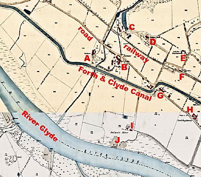
This composite of two maps dated 1860/1 shows a quite rural Dalmuir. NLS © as ref below.
A = Dalmuir; B = Dalmuir - Old paper mill; C = Old paper mill; D = Dalmuir House; E = North West Boquhanran; F = Dalmuir Station: G = buildings at the canal crossing including a post office; H = South Boquhanran; I = Dalmuir Shore (farm); J = Old Quay and mud. There are also becaons along the Clyde shore. Notes show the proposed new channel which we can read as formalising of the edge into a quayside. We also see the railway and the Forth and Clyde Canal as well as some formalised drains, possibly utilised as lades.
As industry, particularly that of the Beardmore Shipyard get established, there is an intensive transformation and urbanisation gathers momentum. BEARDMORE SHIPYARD, DALMUIR.
While there are few vestiges of the once great shipping industry anymore, there are some quality buildings still remaining. "High Dalmuir" was designated a Conservation Area. This is fully documented in the appraisal of 20217. See the link below.
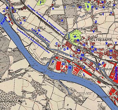
In this map of 1914 you can see the Forth and Clyde Canal running east to west. North of it is the N. B, R, Glasgow, Dumbarton and Helensburgh Line. South of it runs the C. R. Lanarkshire and Dumbartonshire Line.Our view here has Dalmuir placed centrally, but Clydebank has already blurred the edges and Old Kilaptrick is to the west. NLS © as ref below.
A = Dalmuir Park; B = Dalmuir House at the end of Regent Street; C = Dalmuir Farm; D = U. F. Church (United Free Church); E = Tenements facing Scott Street / Burns Street / Pattison Street / Dunn Street; F = Precipitation Tanks of the Sewerage Purification Works (Glasgow Corporation); G = Naval Construction Works; H = Basin adjoining the slipways of the works; I = Gantry out over the tidal mud; J = Station; K = Dumbarton Road crossing of the canal; L = Church and Hall; M = School; N = Station; O = Library; P = Presbytery; Q = St Stephens R. C. Church; R = School; S = Tunnel under the railway; T = Football Ground; U = Subway under the canal; V = Church; W = School; Y = North East Boquhanran; Z = St Peter's Church
To the east is the massive “Kilbowie Factory, Sewing Machines Etc, which since became known as Singer. And we know instantly that we are looking at Clydebank.
To the west we see Old Kilpatick and associated areas.
a = Mountblow estate and its lodge; b = Freelands Place at the merging of the roads; c = Dalnotter Hill; d = Dalnotter House; e = Shipbuilding Yard; f = Low Dalnotter; g = Old Kilpatrick Station; h = Church; i = Spoutgreen Manse; j = Dalnotter Cemetry; k = Auchentoshan Distillery
NATIONAL LIBRARY OF SCOTLAND : MAPS : Dumbartonshire XXVIII.1 (Combined). Survey date: 1860 to 1861, Publication date: 1894. https://maps.nls.uk/view/74478363
and Dumbartonshire XXIII.13 (Old Kilpatrick); Survey date: 1857 to 1860, Publication date: 1862. https://maps.nls.uk/view/74942009
and Dumbartonshire Sheet nXXIII.SW. Date revised: 1914, Date Published: 1922. https://maps.nls.uk/view/75498549
The following are also relevant:
and Dumbartonshire nXXIII.10. Revised: 1914, Published: 1918. https://maps.nls.uk/view/82874337
and Dumbartonshire nXXIII.14. Revised: 1914, Published: 1918. https://maps.nls.uk/view/82874361
and Dumbartonshire nXXIII.15. Revised: 1914, Published: 1919. https://maps.nls.uk/view/82874367
WEST DUNBARTONSHIRE COUNCIL : - High Dalmuir Conservation Area : https://www.west-dunbarton.gov.uk/media/4313719/high-dalmuir-conservation-area-appraisal-190917.pdf
WIKIPEDIA : https://en.wikipedia.org/wiki/Dalmuir#Geography
