
TURKEY RED : 5 - CROFTENGEA PRINT WORKS / ALEXANDRIA WORKS
ACCESS : Most of the site is now occupied by the distillery, but you can walk around the perimeter which includes the towpath along the Leven and India Street.
///shuttled.poodle.stole Gates from India Street / Alexander Street.
///crunched.grudge.frame Incoming lade.
///singing.darts.bank Lade under Strone Road.
The lade through the Croftengea Works is discussed in more detail here TEXTILE WORKS LADES and RAILWAYS
As shown by the maps of 1860 and 1914 below, the initial Croftengea Print Works expanded, subsumed the Levenfield, Bleach and Print Works and became the Alexandria Works; a large industrial establishment. To many though the name of Croftengea remained, certainly in its nickname of the Craft or the Croft. Some remnants of this works remain within the distillery premises. The INDIA COTTAGES, INDIA COTTAGES, INDIA STREET, ALEXANDRIA discussed separately, were part of the associated development outwith its boundaries. Much of that original Works is now occupied by Loch Lomond Distillery.
The locals called this "The Craft", aptly because of the textiles, but perhaps a play on the original name of Croftengea. Some prefer the term "the Croft" as closer to the original word.
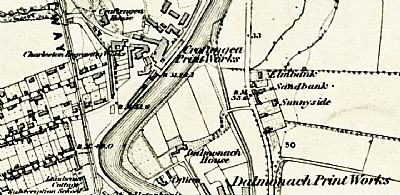
This OS map from 1860 shows the cluster of buildings of the works. Although modified and increased over time, a few still remain. The lade is shown very close alongside the Leven and with a single inlet here, but the waterflow was supplemented by an extension from that of the works further upstream, namely the Levenfield Bleach and Print Works.
NLS ©
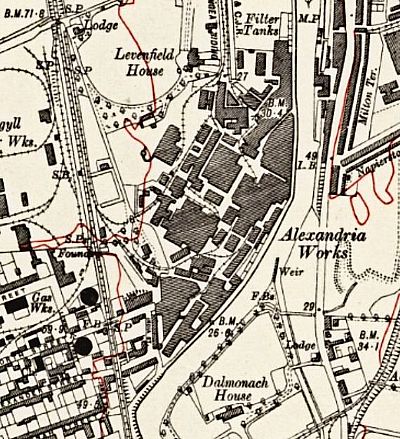
By 1914 the works looked like this. By now it had amalgamated to become the Allied Works. It is this which gives the basis from which to identify some remaining features.
NLS ©
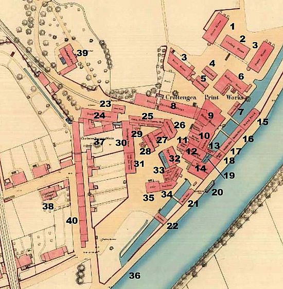
This map dates from 1859. NLS ©
-
STOVE HOUSE
-
COOLING HOUSE
-
STOVE HOUSE
-
MAKING-UP HOUSE
-
MAKING UP HOUSE
-
MACHINE HOUSE / BOILER HOUSE / ENGINE HOUSE
-
JOINERS SHOP / SMITHY
-
BLOCK PRINTING SHOPS
-
MACHINE HOUSES
-
FINISHING WAREHOUSE / MACHINE PRINTING SHOP / PRESS HOUSE
-
ENGINE HOUSE
-
TURKEY RED WASH WHEEL HOUSE
-
MILL WRIGHTS SHOP over the lade
-
WASH WHEEL AND EXTRACTOR SHOP
-
DUNG STORE
-
MADDER STORE
-
MADDER KILN
-
MADDER MILL
-
water wheel
-
filter
-
MADDER HOUSE
-
VAT HOUSE
-
COLOUR HOUSE
-
STUFF STOREHOUSE
-
CUTTING, DRAWING AND ENGRAVING SHOP / BEAM ROOM
-
RED WAREHOUSE
-
STEAM BOILERS
-
SINGEING HOUSE
-
LEAD CUTTING SHOP
-
DISCHARGING HOUSE
-
GRAY WAREHOUSE AND RED STORE
-
DYE HOUSE and filter
-
FINISHING CLEARING HOUSE / CLEARING BOILER HOUSE / SECRET ROOM
-
ROSEY HOUSE
-
OFFICE
-
lade outlet
-
CHARLESTON ENGRAVING WORKS and weighing machine
-
CHARLESTON COTTAGE
-
CROFTENGEA HOUSE
-
INDIA STREET
You can see a reference to the Charleston Engraving Works. This was founded in 1830 to make copper engraving plates for the printworks. It was located beside the Croftingea works in an area then called Charleston. Charleston Row called “Red Row” was the main access road to Croft works and the Leven in 1830. It remained independent until 1897, when with the formation of the UTR it was taken over by the UTR and incorporated in Alexandria Works. [Vale of Leven Project].
There were four drying sheds between this works and the Levenfield Works.
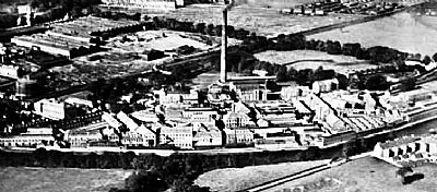
An air view taken in 1927. The Leven is a broad dark line running right to left. The main railway line line runs diagonally behind the chimney stack. Canmore as ref below ©
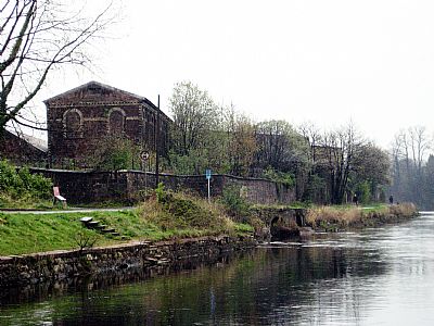
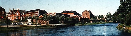 This photograph was taken nearly two decades ago. Much as changed, but the India Cottages can be seen on the left. Note the industrial building to its right without a roof and then compare that to the following photograph. Loch Lomond Distillery has replaced most of these buildings with new warehousing, but not that one nor some next to it.
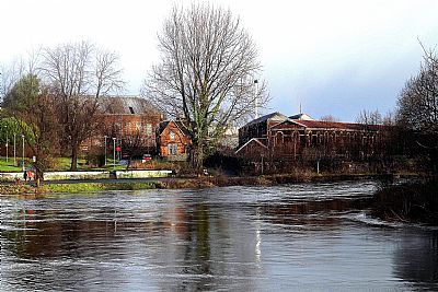
Compare the picture above to this one taken in the winter of 2024.
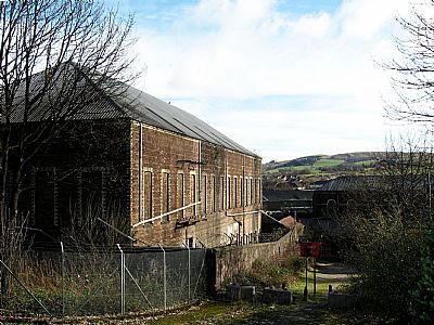
A few of the buildings at the southern end of the works remain. These had replaced even earlier ones.
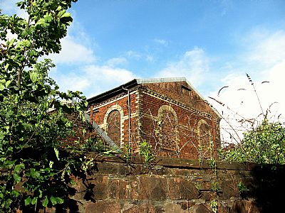
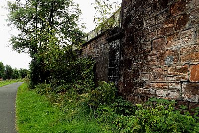
A contemporary view of the enclosing stone wall and the works building since reroofed.
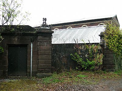
These are the works gates - the workers to the left and right of the vehicle gate. (one has been filled in). They are at the foot of Alexander Street. India Street is to the left. The building in the preceding photo can be seen too. The Leven and the towpath and just out of sight to the right. While rather a narrow pinch of a location for a main gate, it would have had the benefit of easy control and is on the easy route down from central Alexandria.
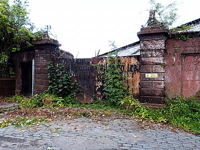
The pedestrian gate to the left has a curved wall behind it presumably as part of a security flow control system. The right hand one has been filled in. You can also see wrought iron lamp brackets on the gate posts.
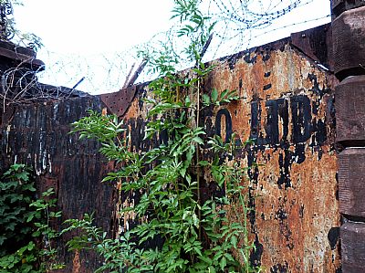
A closer look reveals the signage of LOCH LOMOND BOTTLING LTD which predated the current distillery.
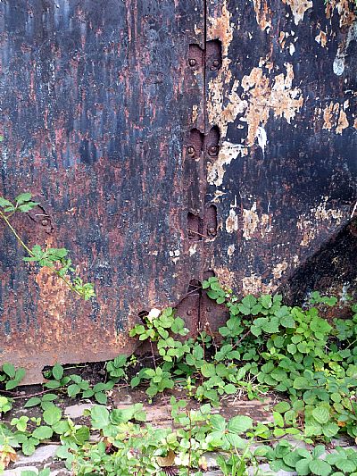
The large steel / iron gates have evidently had extra overlays for security. The inner bolts were accessible through holes and these have rusted.
This is the same narrow point of the site, here seen from the bend in the river. Look closely and you will see the two vaulted arches of the lade as it passed under the site and into the river.
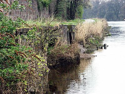
This is a zoomed in view from the same vantage point. While still open, they do not have any flow anymore and silt and vegetation has taken hold. You will notice that these vaulted outlets are splayed for outflow into that of the river. It is also because these are not in direct line with the lade further up. The lade ran from that point towards the river, but then alongside it before exiting.
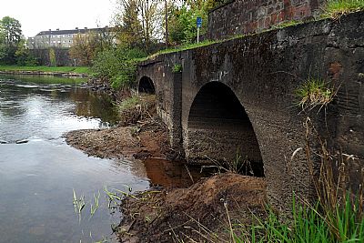
The lade outlet pipes and arches as they reach the Leven. Besides a great deal of sift mud, robust stell fences within them deter any exploration through them.
Getting to work would have been difficult before the bridges were built and made accessible for predestrians and you lived on the opposite side of the fast flowing river. So you needed to use the ferry. In a river fast flowing as this one it is presumed that this was rope operated. If you look at the map above you will notice that many of the buildings are odd shaped that that a narrow lane leads rough north east from an open area within the works towards the boundary wall and the river. The old solid metal gate is still there amongst vegetation in the wall although the buildings within have changed substantially at this point. A little upstream from the gate are the ferry steps.
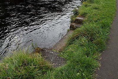
The ferry steps. https://w3w.co/glider.throwaway.crazy
If you look hard you will see the old steel gate. https://w3w.co/energetic.nooks.stoppage
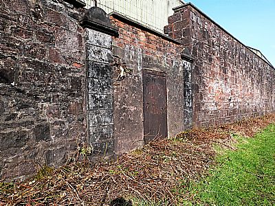
The boundary wall has been obscured along much of its length by the invasive buddlei trees for years. It is damaging to masonry. So after the high winds of Storm Eowyn in January 2025, this was seen as not only an opportunity to clear fall trees, but to clear as much as possible of this troublesome plant and also brambles. In the process the old access gate was exposed.
As you explore the Leven you will certainly find remnants of the textile and related works; odd stones, access points from the river, even the tow-path itself. But some remnants are uncertain. One such item is this steel mast. It appears to have carried a cable, but whether that was for power sharing or perhaps conveyance of small items such as messages and documents is unknown. On the opposite bank is a small building that looks like an electrical box and it appears to have a small mast that would have powered the line. But who would it have served? The larger mast on the west bank is just outwith the works and the small building and smaller mast is rather isolated on the river bank on the east bank. Both maps above show a small rectangle that may indicate the small building and this may have been linked to Dalmonach House beyond.
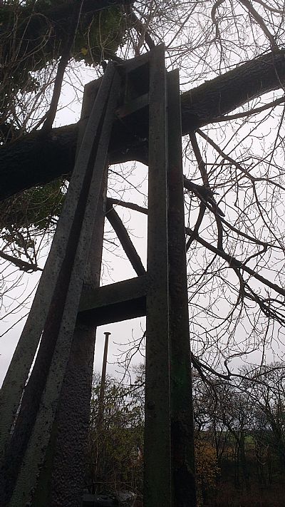
The mast at the bottom of Alexandra Street facing the river. This evidently linked the electricity supply to the manager's house on the hill up from the east bank of the river.
Note that we are talking here of Dalmonach House which also served the Dalmonach works diagonally downstream and across from here ie towards the current Bonhill Bridge. See TURKEY RED : 6 - DALMONACH PRINT WORKS
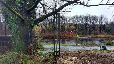
In this view you can see both the mast on the west bank in the foreground and the small building on the east bank. You can see the small electrical building on the far side on top of which is a shorter version of this mast.
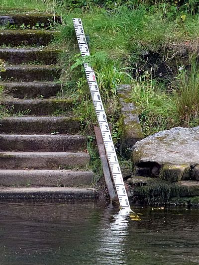
The workers used a chain operated ferry just a little upstream from here. The manager's house though had more elegant steps up from the water's edge. We imagine that he had his own boat access from here. Today that riverbank is covered in thick japanese knotweed. The steps have a gauge rod attached to monitor the river level.
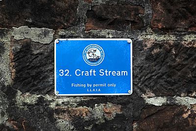
This sign designates an angling zone, but the name comes from what the locals called this works.
Also see : INDIA COTTAGES index.asp?pageid=716489. These were part of the works accommodation and can be seen in the first map.
CANMORE : https://canmore.org.uk/collection/1256158 / https://canmore.org.uk/site/128244/alexandria-croftingea-printworks Works site.
https://canmore.org.uk/site/128243/alexandria-alexander-street-workers-rows Workers rows housing.
COLOURING THE NATION - Wordpress - Project run by the University of Edinburgh and the National Museums Scotland : https://colouringthenation.wordpress.com/turkey-red-in-scotland/
NATIONAL LIBRARY OF SCOTLAND (NLS) : The maps here are reproduced with the permission of the National Library of Scotland.
Alexandria - Sheet XVIII.9.10. Surveyed: [1859], https://maps.nls.uk/view/74415042
1860 : Archive title : " Dumbartonshire, Sheet XVIII (includes: Bonhill; Dumbarton; Kilmar... Survey date: 1860 , Publication date: 1864". https://maps.nls.uk/view/74426619
1914 : Archive title : "Dumbartonshire Sheet nXVIII (includes: Bonhill; Cardross; Dumbart. Date revised: 1914, Publication date: 1923" : https://maps.nls.uk/view/75827346
The composite map above comprises extracts from a set entitled Alexandria : Sheet XVIII. https://maps.nls.uk/townplans/alexandria.html
NATIONAL MUSEUMS SCOLAND : https://blog.nms.ac.uk/2012/06/22/turkey-red-a-study-in-scarlet/
VALE OF LEVEN PROJECT website : http://www.valeofleven.org.uk/valeindustry3.html
WEST DUNBARTONSHIRE COUNCIL : Textile Industry in the Vale of Leven. https://www.west-dunbarton.gov.uk/leisure-parks-events/museums-and-galleries/collections/industry/textiles-and-mills/ and The River Leven Heritage Trail . https://www.west-dunbarton.gov.uk/media/2619077/vale_of_leven.pdf
WIKIPEDIA : https://en.wikipedia.org/wiki/Turkey_red
