
GLASSWORKS, Station Road, Dumbarton.
Site of. This is the approximate site of the glassworks which stretched across an area now occupied by the health centre with the Leven to the west and Station Road to the east. To the south is Dumbarton Bridge and to the north the railway. The glassworks predated the railway and that marked the edge of the floodplain.
ACCESS : Easy access to most of the site. There is little to see though, but a visit gives some idea of early industry.
For the Dixon family home, see LEVENGROVE HOUSE.
A glance at the map and the name of Dixon is very evident both across Station Road and across the Leven. This was because the Dixon family were prominent landowners and industrialists in Dumbarton and because they took control of the glassworks in 1817. However it was initially established back in 1777.
The Dixons became one of the wealthiest glass manufactures in Scotland and were closely involved in the life of Dumbarton, going as far as offering the town large sums of money to pay off debts. Three of the Town's Provosts were from the family: John Dixon, Provost from 1810-1821; Jacob Dixon, from 1822-1830; and Anthony Dixon, from 1831-32. After the sudden deaths of three of the Dixon family partners, James Christie bought the company in 1838 and operated it until its closure in 1850. [WDC].
John Dixon built a house above Dumbarton Bridge to the west called Leven Grove.
What you see today is a rather nondescript mix of buildings and roads alongside the River Leven. In its heyday though huge conical structures dominated the town. They are prominent in many pictures from the time. The last one was finished in 1791 but collapsed while the scaffolding was being taken down, killing six men. It then had to be rebuilt. The works extended over six acres bound by the river and the floodplain just beyond where the railway was to be established.
Later improvements to the riverside included a quay and small slipway. These can still be seen. While not advised due to the very slippery surface of the slipway, it is possible to walk down it to the stoney mud at low tide. It is still possible to find the odd nodules of waste glass amongst the pebbles and other junk tossed into the river.
The river was an essential means of transport of raw materials and fuel in and products out. Coal was the main fuel. The use of kelp which contained soda and potassia was a fairly new innovation which improved the quality of the glass which was essentially sand consisting of silica, soda ash and lime.
The Dumbarton glassworks was very significant in other ways too. During its heyday it owned five coal works, four tramways, two wharves, two bottle works, a brewery, a farm and seven sailing vessels providing transport to other areas in Scotland, England and Ireland. The company ran its own shops or sold to others in Dumbarton, Glasgow, London, Liverpool and New York.
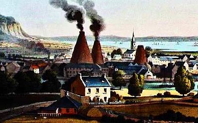
This is an extract from a painting done in 1824 by John Heaviside Clark entitled The Town of Dumbarton. As he was both artist and engraver, other versions have appeared too. You can see two conic funnel shaped chimneys smoking away with anther small one nearby. you can see the River Leven in the foreground with some boats. [The original print is credited to West Dunbartonshire Council].
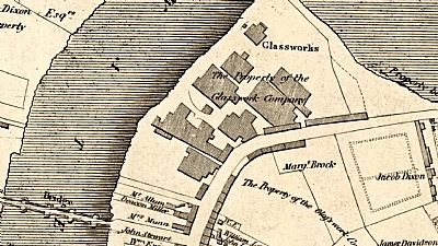
In this map we can see the extent of the works in 1818. The grounds owned by the Dixon family can be seen. On the lower left is Dumbarton Bridge over the Leven. To the top is the lagoon flood plain. The railway had not yet arrived and the lagoon not yet filled in. Strangely, you cannot make out the chimneys so often prominent in art views as above. Perhaps they were within the footprints of the buildings shown here. © NLS as ref below.
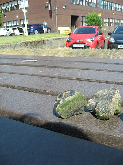
Two glass waste nodules found at low tide near the slipway below Dumbarton Bridge. In the background is the JobCentrePlus building which currently occupies just part of the site. With the glass nodules is an old screw type beer stopper.
ART UK :John Heaviside Clark. (1771 - 1863). West Dunbartonshire Libraries and Cultural Services: Clydebank Museum and Art Gallery. https://artuk.org/discover/artworks/dumbarton-in-glassmaking-days-194883
ASSOCIATION VERRE & HISTOIRE : Innovations in the 17th-century glass industry: the introduction of kelp (seaweed) ash in Britain. http://verre-histoire.org/colloques/innovations/pages/p301_01_dungworth.html#:~:text=The%20kelp%20was%20used%20simply%20in%20combination%20with,not%20immediately%20change%20from%20kelp%20to%20soda%20ash.
NATIONAL LIBRARY OF SCOTLAND : NLS archive description : Wood, John, ca. 1780-1847. Title:Plan of Dumbarton. Imprint:Edinburgh : [T. Brown], 1818. © https://maps.nls.uk/view/74400020
DIXON FAMILY : One Name Study website : https://www.bing.com/newtabredir?url=http%3A%2F%2Fdixon.intco.biz%2Ffamous-dixons%2Fdixon-levengrove-govan.htm
WEST DUNBARTONSHIRE COUNCIL website : https://www.west-dunbarton.gov.uk/leisure-parks-events/museums-and-galleries/collections/industry/glass-making/
