
BENCH MARKS & TRIG POINTS
The roles of bench marks and trig points / triangulation posts overlap; the one being used for level and the other for location.
Bench marks
You have most likely seen these marks set into the side of buildings or even kerb stones, usually those of stone, and wondered what they were for. Some surmise that they marked an upper level of flood water at some time. Well they could be used for that, but are not that directly connected. These are bench marks. To some they look like arrows pointing upwards to a horizontal line. To others they look vaguely like a park bench. But the similarity of name is coincidental.
When an area is surveyed using sophisticated equipment as is done these days, or comparatively simple triangulation as was used in the past, you always needed to refer your measured levels to a fixed point. And you needed to be able to return to that spot again to check or record changes such as with property ownership and development. Being able to refer to a fixed known point is crucial.
The term benchmark, bench mark, or survey benchmark originates from the chiseled horizontal marks that surveyors made in stone structures, into which an angle iron could be placed to form a "bench" for a leveling rod, thus ensuring that a leveling rod could be accurately repositioned in the same place in the future. These marks were usually indicated with a chiseled arrow – specifically a broad arrow – below the horizontal line. A benchmark is a type of survey marker.
The term is generally applied to any item used to mark a point as an elevation reference. Frequently, bronze or aluminum disks are set in stone or concrete, or on rods driven deeply into the earth to provide a stable elevation point. If an elevation is marked on a map, but there is no physical mark on the ground, it is a spot height. [Wiki]
If you are intrigued by bench marks, this website is for you. See the link below. The interactive benchmark archive.
It can be great fun to locate as many as possible near your area. Unfortunately though, not all have been maintained and may have been lost, but those that can be found will be carved into the sides of old buildings or on kerbstones. Bench Mark Bagging is a pastime that is described in the Mrs Physics blog. See the link below. So instead of just going for a walk you arm yourself with a map, put a grid reference on your smartphone and off you set with a description of the position of the benchmark. By exploring this way, you will most likely find places and features you would mornally have missed.
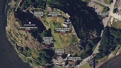
This is how it appears for Dumbarton Castle. Zoom in to see the small red bench mark symbols. Each one has a brief description of its location.
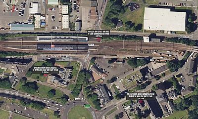
This is the view for the area near Dumbarton Central Station.
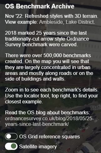
Instructions on the maps. You can choose between satellite imagery or simple maps.
Trig points / triangulation pillars
If you have ever done even the most basic of surveys, be that simply with a tape measure across a room or perhaps outside as a scout or guide project, you will know that measuring diagonal dimensions and the plotting them as a combination of triangles can allow you to draw up almost any terrain to scale. This is known as triangulation. In experienced hands it can become quite complex.
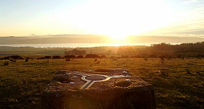
This three pointed metal shape set in a concrete post on the edge of Carman Muir overlooks the Clyde. It provides a firm fixing for subsequent survey equipment at a well established datum point.
These days survey equipment is very sophisticated can measure levels and location simultaneously and the development of scanning surveying is impressive. There are other types of survey too - LIDAR being one. The Atlas of Hillforts of Britain and Ireland has an illustration of such a survey of the Carman Hillfort. See link below.
ATLAS OF HILLFORTS OF BRITAIN AND IRELAND : https://hillforts.arch.ox.ac.uk/records/SC1338.html
INTERACTIVE MAPS - Bench marks - https://interactivemaps.uk/os-benchmark-archive/#16.23/55.944826/-4.564839 This reference centres on the Glasgow Road / Church Street roundabout in Dumbarton. Re- centre it your your own needs, using the zoom.
MRS PHYSICS Bench Mark Bagging blog : https://www.mrsphysics.co.uk/blog/benchmark-bagging/
WIKIPEDIA : https://en.wikipedia.org/wiki/Benchmark_(surveying)
