
The Melincrythan Tramway/Railway
PAUL RICHARDS
This article is a précis of a more substantial article which will be published by the Neath Antiquarian Society at a later date.
Summary
The Melincrythan tramway/railway principally transported coal circa 1885-1903, at first for the Western Moor Colliery with subsequent use by both the Eaglesbush Colliery and the Cambrian Brickworks. The original tramway route began at the mouth of the Western Moor Colliery near Cwm Pandy thereafter crossing the Crythan Brook above the ravine before dropping down through Cupola Wood to a point adjacent to Foundry Road in the Eaglesbush Valley; it then ran parallel to this road towards Melincrythan before crossing Crythan Road and turning sharply to continue in parallel to the Main Road towards Briton Ferry running behind the developing Walters Road before dropping down to pass through an existing terraced house at Mile End Row and across the Main Road to meet the Great Western Railway (GWR) mainline at the ‘Melyn Tin Works’, a total distance of 1 to 1.5 miles. The line was initially a narrow-gauge tramway but was later rebuilt as a standard-gauge railway.
1. Western Moor Colliery & Construction of the Melincrythan Tramway
During the nineteenth century a number of mines operated in relatively close proximity to the Crythan Brook including the Western Moor Colliery - note this is not the Westernmoor Colliery (also known as Eastland Colliery) located near Eastland Road. The entrance (slant mouth) was located in the Cwm Pandy area at the top of Eaglesbush Valley, Fig.1, the brook running right to left across the bottom of the figure.
Figure 1 Entrance (slant mouth) to Western Moor Colliery near the Crythan Brook, late nineteenth century
Figure 1 Entrance to Western Moor Colliery near the Crythan Brook, late nineteenth century
In 1878 ‘The Western Moor Colliery’ was owned by Messrs. John John and William Williams but following closure of the colliery and dissolution of the partnership in 1881 John continued the business as sole proprietor. With extensive knowledge and experience of working in the Cwm Pandy area John saw significant potential for further mining activity, potentially continuing the Western Moor drift. To give the venture increased viability more efficient transport to the railway mainline would be required with a subsequent proposal to build a road/tramway from the mine entrance at Cwm Pandy to link-up with the GWR mainline in Melincrythan. In October 1883 Philip John and John John (‘John Brothers’) agreed terms to work various coal seams ‘from a point near Eaglesbush Foundry to top of Cwm’, and permitted the construction of a tramway from the foundry to the GWR line near Mile End Row. To facilitate this route they were allowed ‘…but one road with necessary pathways...from the Colliery or Pits or mines through the Cwm, to the Eaglesbush Foundry (or fault) together with one acre of land around, Old, Eagles Bush Pit…Messrs. John to have to have power to bring water over old water course from the top of Cwm to the Pit – same as used by late Mr. Geo. Penrose… All Coal worked from the Westernmoor Colliery to pass over new Tramway to Great Western siding…’ As part of coal ownership plans for the Eaglesbush Estate an outline of the route is shown in fig.2 (no date) drawn over the 1877 OS map.

Figure 2 Coal ownership plans drawn-up (no date) for the Eaglesbush Estate
Underground, fig.2 shows the slant driving rightwards from the mouth to run well past ‘Cymmle Common’. Overground, the construction of the route from the mouth may be considered in two parts, firstly from the colliery to meet the section of tramway that would begin at Foundry Road, secondly from this point to the GWR siding at Melincrythan.
1.1 Colliery to Tramway Start
As shown in fig.2 the brothers constructed their route from the mine mouth to run down through Cupola Wood. It can be seen, fig.3a (revised in 1897) that in a direct line from the ‘Old Coal Level’ (Western Moor Colliery closed by that time) the Crythan Brook was crossed, the bridge still in evidence at that time. A fascinating postcard, fig.3b, circa 1913 shows a bridge at ‘Cwmpandy, Top Of Eaglesbush Valley, Neath’.


Figure 3a/b Disused Western Moor Colliery i.e. ‘Old Coal Level’ and nearby crossing of Crythan Brook b) Colliery bridge over Crythan Brook circa 1913.
The description almost certainly places the view as that of the colliery bridge. It is hoped the person sitting below the bridge was kept safe as the area rests directly above the steep ravine! A small portion of the bridge wall remained up to circa 2010 although now removed due to its poor condition and instability. Although no clear plan to Foundry Road has been found there appears to be some traces remaining of a wide passage through Cupola Wood, possibly being that of the original watercourse which may have been in-turn used as the route to the road.
1.2 Tramway Start to GWR Siding
An indenture of 1885 detailed the lower route of the tramway. The complete tramway shown in fig.4 circa 1897 reflects that run by the owners at that time i.e. ‘Eaglesbush (Hughes Vein) Colliery’ the 1897 successor to the Eaglesbush Colliery. It is not believed the route had changed by the time of these later owners. No reference has been found to imply or confirm that there was anything other than a single line laid apart from at the passing-points towards the end of the line (discussed later). As such, the tramway route was relatively straightforward from its start point near the Eaglesbush Pit (including the Cambrian Brickworks), down to the Woollen Factory at the junction with Crythan Road although thereafter it became somewhat tortuous.

Figure 4 Tramway shown running from the Cambrian Brickworks area to the GWR siding, c.1897
The terms agreed in 1883 included some specific details of the next phase of coal transport from the Eaglesbush Pit area ‘… grant right of way for … the construction of a Tramway from a point near Eagles Bush Foundry (on the fault) to a point at back of Mile End Row – with one quarter of an acre of land or sufficient for siding & tipping Stages, Railway to and from that point on to a point adjoining Mr. Dd. Jones’s smiths Shop - and adjoining Great Western Ry – so as to connect with that Railway (but the Messrs. John will have to procure permission from the Highway Board & from the County Roads Board – to cross the Highway & Turnpike roads) …’ In July 1885 it was reported ‘Neath County Road Board - Messrs. John Brothers, of Neath, were granted permission to construct a level crossing near Mile End-road, Melincrythan’. No mention has been found regarding the nature of the crossing at Crythan Road so it is assumed therefore this crossing ran across at road level, i.e. as near Mile End Row, although would have required some form of safety control until building the later railway bridge.
It is not known if trams ran down from the pit area start-point to ahead of crossing Crythan Road under gravity controlled by wire rope, an attached braking mechanism, by horse, or a combination of these methods. A later reference to the crossing at Crythan Road stated ‘…the incline should cease where it did when Messrs. John brothers worked the colliery’ and ‘…they would have to stop where they used to and employ horses.’ This infers that trams at least did not go unescorted over the crossing.
The trams used on the John Brothers’ narrow-gauge line would at some point have necessitated their coal to be transferred into standard-gauge wagons suitable for use on the GWR mainline. Fig.5 shows the line entering the tram-to-railway wagon transfer stage and emerging at right-angles prior to sweeping-down to Mile End Row. It may be reasonably assumed to be the location mentioned in the original agreement of 1883. Fig.5 shows two passing-points on this route at the most inclined sections either-side of the transfer point for full/empty trams and wagons respectively.

Figure 5 Details of tramway at Mile End Row, circa 1897
As mentioned, it is likely that trams were horse-drawn both at road crossings and along relatively flat or gradual gradients. On exit of the lower passing-point a locomotive would transfer the wagons over the Main Road level crossing to the siding. While the majority of the line was built on unused land this was not the case at Mile End Row. October 1885 saw an intriguing quotation for work essentially to punch a hole through a terraced house at this location:
Contractors Office Eaglesbush. Neath 13th October 1885.
To Edward Evans Esq. Norton Villa – West Cross.
Sir, I the undersigned, beg to offer you, to do all that is required to be done, in the matter, of the Railway siding passing thro, one of the Cottages, at Mile End – Eaglesbush - Viz – I will, take down, front, and back wall - also the partition, between the two rooms, - and will fix, Strong Beams in front, and back walls, to receive the joists, of chamber, floor, and walls, also - will put proper support in center of joists, where partition - now stands, together, with proper pillers for the support - of such Beams. The Stair to the chamber not to be damaged for either of the houses on each side, to be damaged - , I hereby agree, to do the above work for you, at once and to find all materials, required to do the above work - and to the satisfaction of your agent - for the sum of seven pounds and ten shillings (£7.10.0-). All the Old materials, to belong to you, - David Love.’
It would be interesting at that time to have the thoughts of the house-holders either-side! A later view of the terraced house circa 1946 which was ‘punched-through’ to accommodate the railway is shown in fig.6 (centre), with the gap to the original siding still evident directly in front of the premises.

Figure 6 Mile End Row showing railway access through the terraced houses, photo centre, c.1946
The required siding was arranged the same year ‘By an agreement dated 24.8.1885 between the GWR and Philip John & John John, the Co. agree on payment estimated cost of £610, to construct junction and siding.’ It was now 1886 and the Melincrythan Tramway was in operation transporting coal from the Western Moor Colliery to the GWR mainline railway.
2. Subsequent Developments
During 1888 a consortium was established to purchase Western Moor Colliery along with the significant unworked mineral rights, ownership of the latter probably the main aim. A draft agreement between the John Brothers and the Eaglesbush Colliery Company Ltd. detailed the latter purchasing from the brothers the whole estate and property. In 1888 there were 81 people employed by the Western Moor Colliery although the same year the colliery was officially noted as abandoned. February 1889 saw an article stating that ‘A company known as the Eaglesbush Colliery Company, Limited, have been formed for the purpose of the purchasing from Messrs. John Brothers their interest in the leases of the Eaglesbush Colliery, with the plant, railway sidings, etc….’ John John was named as the proprietor of the new venture with notification given of the intention to ‘...sink a large shaft to the solid coal’ via Eaglesbush Pit. The Western Moor Colliery plant, machinery etc. was subsequently auctioned-off on February 26 1889. The tramway was thus owned by the Eaglesbush Colliery Company Ltd. and with Western Moor Colliery now closed only relatively limited business would still be available with the Cambrian Brickworks until the reopening of Eaglesbush Pit. Following opening-up this pit during mid-1893 the owners were in a position to request tenders to drive a heading to the unworked coal and this work was completed satisfactorily. However, the mine was flooded in 1895 and after suffering heavy financial losses was abandoned. The company entered into voluntary liquidation, being wound-up in 1896, the sale of property following soon after. Later that year yet another new company was formed - ‘Eaglesbush (Hughes Vein) Colliery Co. Ltd’ and the old business purchased on May 31 1897. It was reported that on July 8 1897 following ‘...stupendous efforts ...to clear the Hughes’ vein workings of water and falls had been crowned with success...the face of the coal was reached...several tramloads of the precious mineral brought to the surface.’ Such was the magnitude of this endeavour that the achievement warranted cannons to be fired in the locality. Now under different ownership there were (once more!) plans to upgrade the transport route to deal with the anticipated dramatic increase in output of coal raised from the reopened Eaglesbush Pit.
2.1 Construction of the Railway
Expedience resulted in the undertaking of coal screening at the pithead to avoid a transfer stage and to replace the narrow-gauge tramway with a new standard-gauge railway, the latter requiring a bridge over Crythan Road and a tunnel under Walters Road. To further accommodate such a dramatic increase in scale certain modifications to the route were required. Whereas the tramway passed between Rock Cottage and the Woollen Factory such a sharp deviation of the new standard-gauge railway line would be difficult for a locomotive to navigate smoothly. Fig.7, (1919 OS map, revised 1914) shows a new banking behind the large single Woollen Factory replacement building allowing the line to run almost in a straight line prior to crossing Crythan Road.

Figure 7 New banking behind the large building on the site of the old Woollen Factory, c.1914
One of the few known photographs of the area, fig.8 circa 1905 shows a portion of the railway.


Figure 8 General view of Melincrythan circa 1905 a) Overall view b) Railway portion enlarged from left of photograph with absence of adjacent properties
A bridge is clearly shown across Crythan Road on post-1899 OS maps, e.g. fig. 7 up to its removal circa 1943 (see later). Early photographs circa 1929, fig.9 show a bridge across the road meeting the start of the run down to Mile End Row. The bridge is clearer in fig.9b.


Figure 9 Close-ups of area at the Crythan Road crossing-point showing bridge resting on top of incline circa 1929 a) View of bridge and run leading down to cross School Road to behind Walters Road b) Close-up of bridge traversing Crythan Road
Note that the bright section in fig.9a seen running down towards the centre of Walters Road is not to be confused with the tramway route, this feature being the initial stages of the later Rockfield Terrace. As the unimpeded route necessitated progress behind and through Walters Road, which by now had a road along its length, it was necessary to cut a tunnel below the road as shown in fig.10a. The Walters Road tunnel is seen in fig.10b circa 1946 by which time it was largely filled-in at the rear.


Figure 10 Railway line sweep from behind Walters Road to Mile End Row a) Circa 1914 b) View of railway route emerging under bridge (photo centre) heading towards Mile End Row c.1946
The use of standard-gauge meant the colliery now had the ability to use a typical commercial locomotive engine along the whole length from pit to GWR mainline. The line was ready for use circa 1898/9 the locomotive purchased being a 0-4-0 saddle tank type dispatched new from the ‘Avonside Engine Company’, Bristol on August 1 1899 and given the name ‘DOROTHY’, a similar style locomotive of 1899 is shown in fig.11a. Railway wagon style used is shown in fig.11b an example of the first order placed with the ‘Gloucester Railway Carriage and Wagon Company Ltd’ (Gloucester RC&WCo.) for fifty wagons on October 1898, a second order was for twenty wagons in the December.

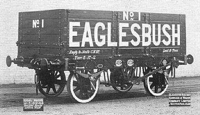
Figure 11 Railway line transport a) Locomotive similar to ‘Dorothy’, also made in 1899 b) Coal wagons (black with white lettering), six planks, side and end doors, 14’6” x 6’9” x 3’9”, November 1898
Unfortunately once again business did not evolve as well as anticipated with the ‘new’ railway only in operation until closure of the colliery in 1903.
3. Post-Colliery Closure
Elements of the tramway/railway, such as the bridge over Crythan Road, the ‘holed’ house at Mile End Row, etc. remained for many years as shown. The fate of the railway line itself was obviously linked with this demise although local memories recall seeing some rails still needing to be walked-over on the way to school during the 1930s so not all rails were immediately removed. At a Borough of Neath Town Council meeting on July 27 1943 it was agreed to use the ‘Emergency Powers Defence Acts, 1939-40’ to remove the ‘Old Bridge, Crythan Road’ during August 23-24. Following the closure of the colliery, the Mile End Row ‘holed’ building was used for commercial purposes, notably ‘Bruno’s Garage’ from 1956 into the 1960s prior to the demolition of the terrace at the end of that decade. The bridge at Walters Road is believed to be present albeit buried under rubble and a section of the concrete incline supports at the junction of Crythan Road/Rockfield Terrace also remain.
4. Concluding Remarks
The Melincrythan coal tramway/railway was originally built to transport Western Moor Colliery coal to the GWR mainline and was a relatively short-lived affair, surviving in similar formats between about 1885-1903. It was a significant undertaking involving a somewhat tortuous route through Eaglesbush Valley, across Crythan Road, passing behind Walters Road, through a terraced house, across the Main Road to eventually join a siding at the GWR line. The legacy of this route remains in the form of some remaining structures with only a few early photographic records having been found to-date.
Some points remain a matter of conjecture and as such any additional information to add to the story would be welcomed.
SOURCES
Neath Antiquarian Society Archives
West Glamorgan Archive Service, Swansea
Period Newspaper Reports
‘Gazetteer of the Coal Mines of South Wales & Monmouthshire from 1854’, RA Cooke, Publ. Tony Cooke and Lightmoor Press, 2018
Britain From Above, www.britainfromabove.org.uk
‘Industrial Locomotives of West Glamorgan’, M Potts & GW Green, Publ. Industrial Railways Society, 1996
‘Private Owner Wagons – A Ninth Collection’, Keith Turton, Publ. Lightmoor Press, 2010
