
Walks 2016
3rd January 2016 – Lady Margaret’s Tower
Our first walk of 2016 was around the Lochnell Estate near Tralee.  From the old stables we climbed up through the trees until we reached Lady Margaret’s Tower on top of the ridge. The clouds lifted, giving us good views in all directions from the top of the tower – across Ardmucknish Bay towards Ben Lora and the Connel Bridge and down the Firth of Lorn toward Oban and Mull. The path then wound round the headland, past an old cottage and down to the beach at Camus Nathais for lunch. Our return route took us to a bay overlooking Lismore and on past the grand Lochnell House to our starting point.
Sunday 24th January - Loch Creran
Parking at the far end of Loch Creran, this walk followed the so-called Pine Marten Walk, through the forest and over the wonderful fairy bridge where we posed for a group photograph.  However, it was there that the photographer very nearly became the subject as we watched him slip ever closer to the raging torrent below. I am pleased to say that he was none the worse of his experience and we went on to have a very enjoyable day out.
16th. March - Inchree
We started the walk at Inchree and followed a steep path up towards a very beautiful waterfall where we stopped for coffee. We then followed a easy forestry road along Glenrigh for about 3-4 miles until we reached the building of a bridge over a river where we had our lunch before turning back. The day was mostly sunny interspersed with a light flurry of snow. A lovely walk and one we should repeat.
20th March 2016 – Loch Avich
 At last – a lovely sunny morning with blue skies! Setting off from near Loch Avich House we took the forestry track that climbed gradually up and then wound along the slopes to the north of Loch Avich. Across the loch we could see the hills around Loch Awe and those of Arrochar beyond. After stopping for lunch at the west end of the loch, with Ben Lui in the distance, we crossed to the south side of glen before taking the path over a footbridge and back along the single track road to Kilmun – a total distance of 9 miles and not a raindrop in sight!
3rd.April 2016 Crianlarich to Tyndrum
 From Crianlarich we followed a forestry path, climbing to the top of a ridge where we had lunch and to enjoy the spectacular views. The route zigzagged through the trees, past waterfalls and sturdy bridges before descending into the valley below. Crossing the bridge over the Fillan River, we took the farm road, past the ruins of St Fillan's Chapel to Auchtertyre Farm and the farmshop (more eats!).
 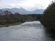 Crossing the A82 we continued along the banks of the River Cononish, skirting the Loch of the Lost Sword, arriving at Tyndrum for a welcome seat and a well-earned cuppa in 'The Green Welly'.
17th April 2016 – Carsaig Bay to Crinan
Carsaig Bay near Tayvallich was the picturesque starting point of our walk, overlooking the Sound of Jura. Taking the track that winds up hill past Carsaig House, with its pretty garden full of daffodils, we came out onto open country with sea and islands in the distance in front of us. The rocks at Sailean Mor bay seemed a good place for lunch before continuing through the forest, where we came across Dounie House hidden amongst the trees. Some of the group then made the steep climb up to the dun on Castle Dounie while others continued along the trail above Ardnoe Point. Despite some thickening cloud, we were rewarded with views westwards to Jura and Scarba and north to Luing and Craignish. Finally, we had a steep descent down to the shelter of Crinan Harbour before taking a concealed footpath around the headland into Crinan itself.
P.S. To those on the walk - I am reliably informed that the yellow flowers we saw by the burn are American Skunk Cabbage!
1st. May Loch Melfort
Starting from Melfort village we took the road along Loch Melfort winding up the hill at Ardanstur till we came to a gate in the fence and a track climbing up the hill towards Cruach nam Fearna. After the initial steep ascent the track continued gradually uphill below the crags with lovely views looking back down to Loch Melfort. We then continued through another gate and into the forest encountering some patches of snow, showing that winter is not yet over. 
As we came to a clearing in the trees this gave an opportunity for those adventurous individuals in the group to continue the last ascent to the trig point. While half the group enjoyed a spot of lunch the rest of us scaled the last 50 metres of Cruach nam Fearna to gain 360 degree views looking out to Mull and across to Luing.
The excitement of the day was not yet over. Continuing along the forest track after lunch we encountered various parts of the track covered in fallen trees. After 10 minutes diverting round the worst of these (up over and round about!) we retraced our steps and managed to find a much more suitable path. The forest finally opened out and we had more lovely views as we walked back down the hill to the road. From here we continued along the road back to Melfort village.
We finished off a lovely days walking with some refreshments in the cosy Culfail Hotel bar, complete with open fire.
15th. May, Island of Luing
We assembled at Cuan, south Seil, and took the 11 o'clock ferry over to Luing. 10 of us set off south on the little island road, with primroses, bluebells and violets thick on either side. We took a right turn and had lunch sitting on a rocky outcrop, overlooking the tiny slate island of Belnahua. Turning right again we joined a track making for the village, where we wandered around admiring the views and looking at the tiny old slate quarry workers' cottages.  Looking from Cullipool over to Mull, we were lucky to see a section of shore line changing...clouds of rising dust and rough water below meant that a huge section of cliff was falling into the sea. When the dust had settled one could see a new sheet of exposed rock, shining in the sun. This happened on the S.E. high cliff between Loch Buie and Loch Spelve, more specifically just east of Frank Lockwood's Island.
  We had tea at the beautiful new Heritage Centre, then made our way back to the ferry. We took sheep tracks up to high pastures where we could see Colonsay and Jura to the south, and Mull, Morven and the Lorn hills to the north.
The photo above is of our walkers at the Fairy Knoll.
The little island of Belnahua (meaning mouth of the cave) which we looked onto at lunch time, is barely half a mile square and supported around 150 people at the height of its industrial prosperity during the great days of the slate boom. But this very activity was to prove its downfall, for so intensive was the quarrying that almost the whole surface of the island, with the exception of that part of it on which the workers' dwellings actually stood, was entirely eaten away until only an empty shell remained. Because of this the ravaged little island had to be abandoned during the early years of the twentieth century.
The central road a through Luing passes down the long Glen Dubh Lettir, the Glen of the Dark Slopes. In the past this area was believed to be inhabited by evil spirits, chief among whom was Ghlaisrig, a huge and malevolent demon whole pursued travellers under cover of darkness or through the grey enveloping island mists. A boulder known as the Creagan a'Ghlaisarig, or Demon's Stone, reputedly marked with the imprint of a great claw, stood until recently in a broad trap-dyke half way down the glen, just north of the present school.
Near this spot may still be seen the Fairy Knoll, a small grassy hillock about four feet high, standing by the roadside at a point where the tiny Eas an Frogach, the waterfall of the hollow, tumbles down the brae through a small half-hidden grotto. It has long been customary for travellers to pause at this spot and respectfully lay a small personal offering of a hair or thread of clothing on this tiny eminence as a placatory gift to the spirits of the glen - and the custom still continues to this day.
5th. June. St. Brendan's Seat
 The walk started near Duachy Farm, up the hill to the standing stones, unfortunately only one still standing, then on to St Brendan's Seat. However, despite various efforts to find out the history of the Seat, no one seemed to shed much light. Then it was onwards up Beinn Mhor and the trig point, with magnificent views over Seil, Kerrera and Mull. and where we had our picnic. This was followed by a gentle circular walk on a farm track, and back to the cars. This walk was on one of the warmest days of the summer so far, so the Iron Bru at the end of the walk, courtesy of our Chairman, was much appreciated.
3rd July 2016 – Black Lochs
It was a mild but cloudy morning when we set off through Connel village before taking the track across the fields and past Achaleven farm. Then a gentle uphill climb gave us views back across Connel Bridge towards Ben Lora – but the hilltops in all directions were hidden beneath the low cloud.  As we
As we
approached the houses at Cuil-uaine, the first of the Black Lochs came into view and a little further along by the second loch, we stopped at the ruins of an old village for lunch. We saw lots of orchids as we headed past Kilvaree and then all of a sudden the rain arrived – a 20 minute downpour that tested our waterproofs and boots. But by the time we reached the single track road to Connel, the skies brightened and the walk back to the cars gave us time to dry off!
17 July 2016 – Acharn Forest Walk, Killin
It was a mild, overcast morning when we set off from the car park in Killin. The walk began by tracing the route of the old railway line, passing through a section of broad-leaved woodland before turning up through a forested area of mixed conifers. We continued the gentle ascent until we reached a spot where the track levelled out and we were able to sit and enjoy our lunch beside a pleasant little waterfall. 
After lunch we left the main track and followed a narrow woodland path which bordered a pretty mountain stream. This brought us out on to a quiet public road. From here, a very short road-walk took as back through Killin village via the picturesque Falls of Dochart. We ended our day with a welcome hot drink at the ‘Green Welly’
7th August 2016 –Oban Summit to Connel (late replacement for Mull walk)
 With strong to gale force winds forecast and the ferry on amber alert, it was decided to cancel the Mull walk rather than risk getting stranded on the island. So instead, a small group of us who had met at the ferry terminal headed up past the golf course to the Summit beyond Achnalarig and walked from here to Connel and back along the old drove road. It was blustery walk but we could still see Beinn Lora and Ardmucknish Bay in front of us. On the return leg, with the strengthening wind in our faces, we spotted a hen harrier swooping over the fields and a mass of mauve orchids amongst the long grass. Then, about half a mile from the car, the rain arrived! A short but enjoyable walk before the weather closed in for the afternoon.
21st August 2016 –Kinlochleven
From the Grey Mares Waterfall car park we took a path which wound gently upwards through the woods, with a view of the magnificent Grey Mare Tail’s waterfall glimpsed through the trees. Shortly after crossing a footbridge the track became much rougher and rockier as we climbed steeply uphill above Kinlochleven, gaining good views of the loch and surrounding hills despite fairly low cloud cover.  On reaching what was once was a stalkers path but is now a wide track suitable for hydro-scheme vehicles, we turned east and made our way to Loch Eilde Mor, where we stopped for lunch. We then returned along the track, following the contours of the hills until we reached Mamore Lodge where, after a brief stop, we headed downhill, soon meeting the West Highland Way which took us back into Kinlochmore and our starting point
4th. September, Glen Lonan
6 of us left Taynuilt station, and followed a path north, alongside the golf course, and along Airds bay. Turning south to cross the main road (A85) we continued up to Balindore and Barguillean. We paused to admire two bulls in different locations on the walk...they don't faze us !  The views were good, especially looking north across Loch Etive, and we got a bit smug about the sunny weather. However, when we stopped for lunch, (having reluctantly decided not to follow an enticing-looking grassy track to the east), the rain came down and we waterproofed up and made a smart return trip. We noticed that the roads were dry as we approached Taynuilt again. It was a good walk, and we've made a note to explore the 'grassy track to the east'.
18th September 2016 – Ballimore Estate near Kilchrenan
 The Ballimore Estate lies just north of Kilchrenan and a good track led us past Loch Tromlee where there is an island with the ruins of an old castle on it. On reaching the Farm Estate House and its cottages, we took a footpath that winds over the hills towards Loch Awe and Ben Cruachan, but the low cloud hid even the Cruachan dam from view. The going under foot was boggy and damp and a gentle drizzle started to fall - but fortified by lunch, we carried on to Tervine! The return route took us past an old sheep fank, then uphill and across a couple of burns and eventually back to the track and our starting point. Despite the weather, we were all in good spirits – a day that definitely put our boots and waterproofs to the test!
Glen Strae 2nd. October
 On a truly beautiful morning we assembled at a car park beside the River Strae where the Stronmilchan road takes a deep bend. We agreed that a longer walk than advertised was in order, so we meandered up some miles along the river, stopping to take photos and generally ooh ing and aah ing over the sight of mountains, meadows, water ways, and trees that surrounded us. Ahead of us was the shapely Beinn Mhic Mhonaidh and in the green hill slopes around us we could hear the stags bellowing, when we stopped to listen carefully. Also on the slopes and on the floor of the glen were the remains of long abandoned sheilings, and the mewing of buzzards above. It was one of those days when one could have walked forever. But we returned to the cars , and made a quick visit to Kilchurn Castle on Loch Awe, before returning home.
16th. October, Ardmaddy

From Ardmaddy we took the track that leads south but instead of continuing on towards Degnish , we branched off on a path that wound its way up hill, giving us good views over Balvicar and Seil to Mull in the distance. At the top we came across the picturesque Loch nan Ceardach, (a good coffee stop!) , before following a route that took us back down to the main track. Turning north, we soon came across the Wishing Tree, now adorned with brilliant ribbons as well as lots of coins, and then we again left the main track and took a footpath down to Ardmaddy Bay. After lunch, ignoring a bit of drizzle, we walked round the bay and over the headland to Seil sound before returning back past Ardmaddy Castle, with its unusual tower, and along the driveway to our starting point.
Gold Mine, Tyndrum, 6th. November 
11 of the Oban Walkers assembled at the Green Welly car park, Tyndrum, on a sunny morning, and started off through a forest path in a S.W. direction. We met a good vehicle track and followed it and the River Coronish upstream. Ben Lui dominated our view ahead, and in particular the coire (Coire Gaothach) that holds much snow in the winter and spring months. As it was, there were glimses of snow on the summit, and some surrounding tops had a light dusting. Although it was sunny, there was a cold north wind, and we didn't hang around at our lunch stop. On our return, before deviating onto the West Highland Way, some tried their hand at gold panning. I don't think they were successful, or perhaps they were, and kept it secret! Back to the car park and a cup of tea in the cafe. We were lucky to have had such a day of sunshine and autumn colours as the nights are really drawing in...
20th November 2016 – Glen Orchy

It was a chilly morning with mist on the hilltops when we crossed the slippery bridge over the River Orchy at the Eas Urchaidh Falls. We followed a track that wound through the forest, the trees still covered with a layer of frost, until we reached the remnants of the ancient Caledonian Pinewood of Allt Broighleachan. On the return route the sun had burnt o& the mist, giving us a glimpse of snow covered hills against a bright blue sky.
4th. December 2016 - Druim Mor above Oban
This was a very local walk which took 8 of us onto the hill just south of Oban, looking onto the sound of Kerrera and over the island. (The enclosed photo was taken on another day. Our weather wasn’t quite as good.) Recent snow had melted off the high tops, and cloud was hanging around the Morven and Glencoe hills, and Ben Cruachan. Little shafts of sunlight lit up gold patches. We reached the (seasonally empty) caravan and camping park at Gallanach and returned home by the Right of Way drove road that sheep and cattle used in days of yore, to reach markets.