Sandy's Blog
Cromarty's Lost High Street
by Casagrandeblog - 22:33 on 22 April 2013
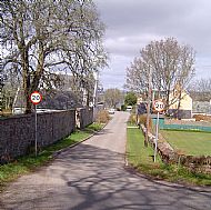
When we decided to make buildings the focus of this project, we said we were not only interested in existing buildings but also in ones that have disappeared. Lots of houses have been demolished in the Fishertown, but the one place where almost all the houses have disappeared is the Causeway - formerly the Castle Brae, and before that the High Street of medieval Cromarty, running downhill from the old castle to the sea.
 Back in 1998, David Alston led a team of researchers looking through old maps and documents to try and get a picture of the street as it used to be - before the 18th century Laird, George Ross, began buying up the old houses and knocking them down. The Householders List of 1744 indicates twelve ‘tenements’ plus the ‘old burgh house’ or Tolbooth in the street. The Tolbooth and the market cross were situated at the bottom of the street, on the east side, opposite the end of the present Miller Road.
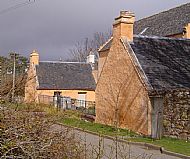
Scottish burgh laws in the middle ages usually specified that the tenements, or ‘burgages’ should be about 20 feet in width. These would be gable end onto the street, so if you allow for a path up the side, the actual gables should be about 18 feet wide, and that is what the gables at the Old Manse, the Kennels and Clunes House still are. The gables of the older houses in Church Street and on the Braehead are the same size.
What often happened at a later stage is that several tenements were combined into one property; the middle ones were demolished and a new front-facing block built in the space - giving a large house with two wings like the Kennels.
 At least Cromarty’s medieval High Street still survives, unlike the street known as Thief’s Row, which ran from below Clunes House across the Reeds Park to the Colliesheugh well. The 1744 Householders List showed no less than 11 properties here. All gone.
None of us have memories of these lost houses, but I like to think about what life must have been like in that busy wee community.
Add your comment
