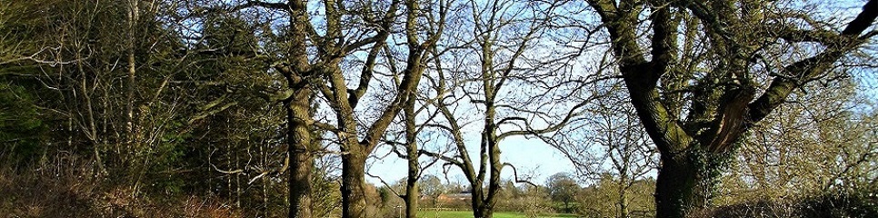
More Walks Around Cold Ashby
{The Rambler strives to give accurate descriptions of the walks on this site but is aware that any text is always open to a variety of readings and possible (mis)interpretations.
He therefore strongly recommends that walkers are equipped with a relevant O.S. map (Explorer 223 or 222) and decent compass which should enable them to regain the intended route should they be unintentionally misled - please do not rely only on his meagre attempts at sketch maps!
Constructive comments and/or criticisms are always welcome here.}
Quick Links to Walks on This Page:
[6] Hemplow Hills Circular
[7] Bridge 31 – Bridge 34 – Hemplow Hills – return via Hemplow Drive and Stanford Road
[8] Welford - Old Sulby - Sibbertoft - Welford circular.
[9] Cold Ashby (via White House Farm) to West Haddon, Winwick and return.
[10] Hollowell to Cottesbrooke Hall and Return.
(Click here for original 'Walks Around Cold Ashby' page)
**For walks within easy driving or cycling distance of Cold Ashby see Cold Ashby's Rambling Explorer , Rambling Explorer Continued and More Rambling Explorer
[6] Hemplow Hills Circular

Starts at: Bridge 31
Distance : about 3.5 miles
Difficulty: slight climb up through woods on Hemplow, otherwise level.
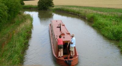
This walk starts from Bridge 31 on the canal, which is on the Stanford Road - limited parking is available on the verge near the bridge.
(It is, of course, possible to reach this on foot from Cold Ashby using the Jurassic Way from Honey Hill via Elkington and thence the canal towpath - which would probably make the total distance about 10 miles if starting from, and returning to, Ashby Church.)
From Bridge 31 look for the Jurassic way sign which points through the hedge towards The Hemplow Hills, the prominent wooded heights clearly visible N.E of the Bridge.
The path is always clear here and you will see where it enters the woods ahead.
Do stop before going into the woods and look back to admire the view of Honey Hill to your left and the rolling landscape ahead and to your right. (Unfortunately, you now also get a chance to assess the volume and pace of traffic on the A14 about a mile away below you!).
Climb up through the lovely mixed woodland, soon emerging on to a wider green track through the trees. Watch out for a new sign on your left indicating a permissive path which you follow to a gate at the end of the wood. At this point a green arrow points sharp right. Go through the gate, admire the view ahead and then turn right, continuing with the woodland on your right.
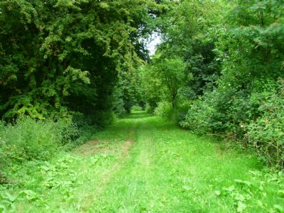
As the woodland ends, continue along the permissive path (which you may have noticed serves as a point- to-point course) bearing N.W. towards the canal which is visible as a line of trees and vegetation ahead. Just before reaching the canal a sign shows a bridleway ahead which soon bears S.W. to reach Bridge 34 which you cross to reach the Towpath and from there continue along the canal via Bridges 33 and 32, eventually regaining your starting point at Bridge 31.
[7] Bridge 31 – Bridge 34 – Hemplow Hills – return via Hemplow Drive and Stanford Road
As in the walk above you begin at Bridge 31 but, instead of taking the Jurassic Way up to the Hemplow woods, follow the canal towpath along to Bridge 34 and then the bridleway and permissive path to the Hemplow ( this is, obviously, the final section of the above walk in reverse). When you reach the end of the permissive path in Hemplow Wood turn left (North) along the Jurassic Way and leave the wood, passing the large house and estate on your left, not failing to notice the intriguing 'folly-style' architecture of two of the new buildings. (The Rambler has not included a photograph here as he would not wish to spoil your experience!)
Continue on the Jurassic Way until you reach a T-junction with Hemplow Drive, which is a bridleway. Turn right here ( South) onto Hemplow Drive and continue down this until you reach the Stanford Road*.
Here you turn right and walk along this narrow road ( watching out for spasmodic traffic) to Bridge 31.
*Alternatively, look for the permissive path on your left as you walk down Hemplow Drive and use that to explore and enjoy the views from Prince of Wales Spinney before emerging on the Stanford Road a few yards East of the drive and continuing to your starting point along the Stanford Road.
[8] Welford - Old Sulby - Sibbertoft - Welford circular.
(Heaps of History in about 6 miles!)
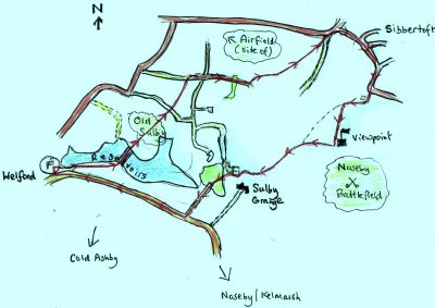
On this walk you will cross reservoirs constructed to feed the canals , walk through a fine example of a medieval deserted village, pass close to a former World War II airfield and enter the Western edge of the Naseby Battlefield.
Starts at: Sulby Reservoir Car Park
Distance : about 6-7 miles (depending on how interested you are in the Battle of Naseby!)
Difficulty : no real ups or downs but a bit sticky at some points in wet weather so wear 'proper' boots.
The walk begins at the car park on the Welford to Naseby Road next to Sulby Reservoir.
[ You can, of course, reach this starting point from Cold Ashby, either by using the Bridle Lane route or the Jurassic Way ]
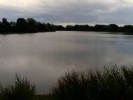
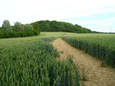
From the car park follow the Jurassic Way/Reservoir Walk waymarkers, passing along the Western shore of the Eastern ( Welford) reservoir and then crossing between the Eastern and Western ( Sulby) reservoirs. Look out for the resident herons (perhaps also enthusiastic about carp?). I saw one on the reservoir and two in flight during my last visit.
After this crossing, keep following the excellent waymarkers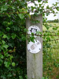 (as pictured left) across the field and continue on the Jurassic Way through the pasture which covers the remains of Old Sulby Village.
Here, take time to notice the clear rectangular raised platforms which were once houses and the hollow ways which were the lanes. According to the County Council's Jurassic Way (Central Section) leaflet, 'records show that between 1377 and 1428 the village disappeared ... this was probably to make way for sheep pasture' (for the Rambler's comments on this process in the area see History Beneath Our Boots) but the Bubonic Plague, which was apparently rife in Northamptonshire in the middle of the fourteenth century, may also have hastened the abandonment of this settlement.
Continue, passing Park Farm on your right and bearing North East.
You walk across a track and cross a field to another track, which, as the waymarkers indicate, you join, turning right towards Sibbertoft.
You then pass through a small wooded area before reaching the Western edge of Sibbertoft via clear paths on mainly arable land.
To the left (North West) of this section is the site of the southern end of the the Second World War Husbands Bosworth airfield. The Police Support Helicopter now operates from part of the original aerodrome nearby and the Rambler found it quite startling as it takes off!
The Northern section of the wartime airfield is now a gliding centre.
On reaching Sibbertoft and emerging onto the road, turn right and walk in the direction of Naseby and Kelmarsh until just beyond the Sibbertoft signs at the Eastern entrance to the village where you will see the road turn sharply to the left.
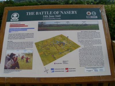
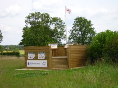
Leave the road on the track with the bridleway and battlefield signs pointing you South along a clear track. From here, you continue to the flagged viewpoint at Sulby Hedges, which gives you excellent information on the Battle of Naseby itself and the local wildlife. You also have the opportunity to follow the path around the edge of the field, marked by posts with white rings.
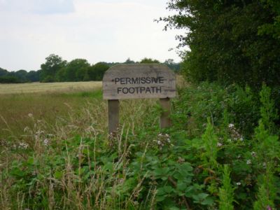
From the Viewpoint you need to retrace your steps towards Sibbertoft for a short distance and look for a wooden sign (pictured) announcing a 'Permissive Path'.
Take this path in a South Westerly direction which eventually joins an official, waymarked bridleway, taking you towards, and then through, the woods between the Eastern tip of Sulby Reservoir and Sulby Grange.
Emerging from the woods turn left and walk South down the long, broad green lane to the Naseby Road. You then turn right and walk along this road towards Welford for about 3/4 mile to reach your starting point.
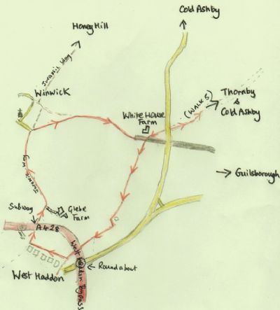
[9] Cold Ashby (via White House Farm) to West Haddon, Winwick and return.
Distance: 5-6 miles this section, about 10-11 miles in all
Difficulty: Well marked, fairly level, muddy in places if wet.
This walk is a variation on Walk [5] ‘Cold Ashby to Winwick, passing Thornby Grange etc.’, described on this page.
You follow this former route as far as the gates to the left of White House Farm but, instead of walking ahead on the byway (incorrectly designated ’bridleway’ on the gate!) , turn sharp left on the waymarked footpath in the direction of West Haddon (South West).
The waymarking is very good on this section and the path barely deviates from its South Westerly course, although there is a possibility you may miss your way if you fail to spot this footbridge on your right:
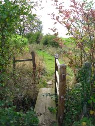
The Rambler enjoyed this section, primarily because it feels much further from roads and civilization than it actually is, but also for the quaint signage ...
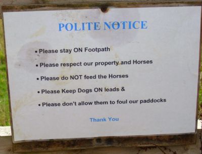
... a pleasant change from the more negatively pseudo-prohibitive stuff we ramblers learn to ignore!
If you reach the West Haddon By-pass and have missed this specimen...
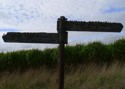
... on your right, you may wish to return the short distance to marvel at the state of it!
Negotiate the steps and by-pass with care, turning sharp right (North West) and walking with the backs of housing on your left on a clear path until you reach the junction with the Jurassic Way.
If you wish to explore West Haddon, turn left and follow the Jurassic Way into the main part of the village.
Should you wish to press on for Winwick, then turn right to the subway under the by-pass, emerging with Honey Hill and its telecommunication mast clearly ahead on the horizon.
From the subway continue Northwards on the Jurassic Way , passing Glebe Farm on your right and continuing on the track into Winwick.
If you have not visited Winwick before, and you have the time, the Rambler strongly recommends it.
From Winwick look out for the byway ( green sign) that leaves the Jurassic Way just beyond the gates to Winwick Manor and takes you on a clear track back to White House Farm
From here you may return to Cold Ashby (via Thornby Grange) by reversing the outward directions.
(Alternatively, of course, you can make this a much longer walk by continuing on the Jurassic Way up Honey Hill before returning to Cold Ashby on the Stanford Road).
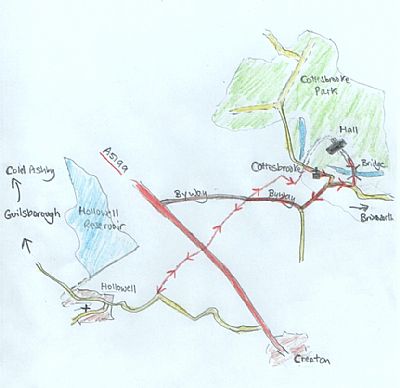
[10] Hollowell to Cottesbrooke Hall and Return.
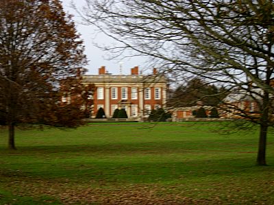
The Rambler recommends this walk for Jane Austen fans as Cottesbrooke Hall is believed by some to be the model for Mansfield Park.
It begins and ends in Hollowell, which is about 4 miles South-East of Cold Ashby along country roads (via Guilsborough) .
Starts at: Hollowell Pocket Park
Distance: about 4-5 miles
Difficulty: mostly easy going - except for a steady climb up to A5199 crossing on the outward trip and far too much mud on the byway in winter - be sure to wear good, waterproof boots
Unless you are keen to trudge the aforementioned roads between Ashby and Hollowell ( the scenery is good but you can enjoy most of it on my other circular routes ) I suggest you park in Hollowell and make your way to the ‘Pocket Park’ at the outskirts of the village on the Creaton Road.
To the left of the entrance to the Pocket Park you will see a clear, signed bridleway which takes you pleasantly for about a mile to reach the very busy A5199.
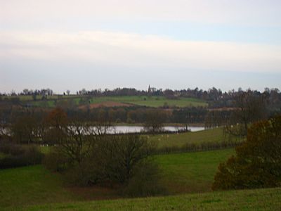
Before crossing to the footpath directly opposite, taking great care to assess the excessive speed of the traffic, you can look back for a view of the reservoir and Guilsborough Church on the skyline.
The footpath on the other side should take you straight on , across the middle of the field.
Today, the path was not clearly visible on the ground ( the field having kale or something similar growing in it) but the signage at the field margins plus the ordnance survey map confirm this as the correct right of way.
This footpath brings you to a very well used byway which you walk straight across to pick up the continuation of your path towards Cottesbrooke village.
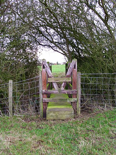
This path continues directly across the rolling pasture until you reach a gate. Do not make the mistake of continuing through (or possibly leaping over?!) the gate but notice on the right-hand gatepost the black waymark arrow demanding that you turn right and continue to the corner of the field , where you negotiate an interesting stile-cum-footbridge.
 At the time of writing (December 2011), the gates were open and I was able to enjoy a view of the bridge, lake, parkland and the hall itself. I now understand, however, that public access to Cottesbrooke Hall and grounds is only available to paying customers during the opening season. For details please check the official website.
Turn sharp left, immediately after crossing the bridge and follow the path , keeping the church tower in view to your right, and eventually emerging on the main street.
For a fine view of Cottesbrooke Hall, turn right and continue down the street past the gatehouses and Grange on your left and the church on your right until reaching the junction of Brixworth Road and Creaton Road (signposted).
Continue along the Brixworth Road, noting the many attractive stone buildings until you reach the entrance to the Hall and park.
In the warmer weather, a gentle stroll through the village and the attractive surrounding parkland in the direction of Naseby and Haslebech is recommended. This also offers further views of the Hall and its setting.
After, hopefully, enjoying this view, retrace your steps to the junction with the main street and Creaton Road.
Follow the Creaton Road for about half a mile until you reach the byway on your right. This is the byway you crossed on your way out and it takes you back to the footpath across the field and thence, again crossing the A5199 with care, to the bridleway back to the entrance to the pocket park in Hollowell.
** This walk can be linked with Rambling Explorer Walk 1

Any comments or observations are most welcome on the Feedback or Guestbook page.
(See Walks Around Cold Ashby , Cold Ashby's Rambling Explorer and The Three Hills Walk for more local walks.)
