
Exploration
On this page I will post details of some local kayaking possibilites? which may or may not have been paddled before. Theres no guarantee that any of these burns can actually be paddled or you may find that they only rarely come into condition. You are highly unlikely to find a 'classic' which has been hidden away all these years, however if you are in the right place at the right time 'go for it'. One characteristic of the small burns in Central Scotland is trees, so many might not be possible without remedial chainsaw treatment!! The notes below are guidance only. Get some OS maps and go EXPLORE.
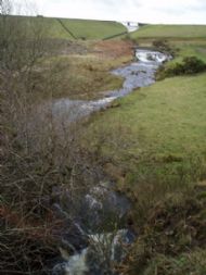
Bannockburn from North Third
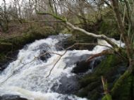
There is the Dam spillway which has been done.
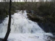
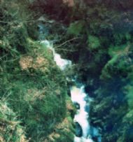
After this there is a small fall and then a short narrow gorge, a 2m weir and then the falls shown here. Overall drop is about 6m.
Unfortunately the lower part of river is not possible without extensive tree removal work !
Carron Glen
Described is a 10km stretch from Carron Valley Reservior to Denny.
From Denny take the B818 west towards Fintry.Parking is possible in a lay-by at the west end of Fankerton from which the hardest rapids on the river can be inspected with a little scrambling down.
I reeced this river many years ago and have always meant to come back and paddle it but never have. I find it difficult to believe that it has never been paddled but equally have never heard anyone mention it. The floods in December 2006 have altered the river removing many trees- damage to the banks shows that the level rose to over 3M higher in some parts. Most of these trees are piled up against the footbridge at Fankerton which was been badly damaged and blocked the whole river. The footbridge has now been removed and access to the North side of the river is only possible from Denny along the Wildlife Trust path.

The river is a small boulder strewn type as photo above with a number of harder falls on it. Unfortunately the main flow is restricted by the Carron Dam with very few feeder burns running into it after this. The Carron therefore will only run in very high spates when the dam is full and overflowing.
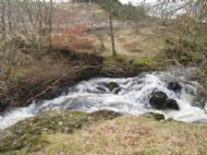
I reckon that the boulder sections would be up to a continuous Gr3 when in spate with a couple of harder sections which would need inspection. There are a couple of narrow gorges with falls that should go at about Gr4 but in low water do have underwater siphons and boulders obstructing.

The final fall has a 4M sloping weir with a huge holding stopper in higher flows.

This runs straight into a fall into an impossibly narrow undercut gorge (Ladies Leap). This could go at about Gr5 depending on water level but looks serious.


I'm told that the river farther downstream has been paddled and has a playwave. Theres an old weir and rapid at Larbert. I guess in these lower stretches water quality could be suspect.
Loup of Fintry
At the other end of Carron Valley Reservoir flows the Endrick. This river is mostly flat water gr1 apart from 3m falls at Pot Of  Gartness a renowned Salmon leap and at the Loup of Fintry beside the B818.
This can be very impressive in flood but as there is nothing else on the river it never seems worth the effort to do just this one fall and annoy the millions of fishermen.
 The upper end of the Endrick may give some possibility in high water but I haven't inspected this.
THE LOUPS
The Reservior diverts most of the upper Endrick away and apart from extremely high levels leaves only compensation water in the river. It is worth looking at the 30M high Loup of Fintry waterfall even if its just to discuss theoretical lines down it. Very impressive in high water.
The Devon Basin
River Devon
The Devon is a pretty little river with 20 odd K of easy grade1 paddling in its lower reaches but it has a couple of challenges described below.
The Devon rises in a remote glen on the Ochils and flows from Glendevon reservoir. In high water the spillway of the dam presents a formidable challenge. yet to be done??


From here on in high spate there is bouncy gr2 to Castlehill Reservior.
When I lived at yetts O'Muckhart one of my neighbours had been involved in building this dam. He told me about the excellent falls which were unfortunately drowned by the building of the reservoir- shown below in this early  photograph taken in 1910 by R H Adam.
Below the reservoir the river potters on at Gr1/2 with only fences across the river to relieve boredom before excitement starts at Crook of Devon where there is a 3m weir. From here to Rumbling Bridge the river gathers pace.
At Rumbling Bridge the river drops into a narrow 36M deep gorge. The most significant fall is called the Deil's Mill; so called because the water falling onto rocks below continues to grind on a Sunday. There are paths which go all round the gorge and it is possible to inspect some parts from above.
I have scraped down the gorge in low water - in fact the gorge presents an excellent gorge walking challenge in lower water. In high water the tight falls, potholes, constrictions and potential log-jams make this a very serious proposition and as far as I know has not been attempted. Once in the lower gorge proper there is no way out until the end.
The river has been canoed from below the Bridge down to Vicar's Bridge. There is a significant waterfall, Cauldron Linn which unfortunately will never be paddled as due to a rockfall in 1881 the base is littered with huge blocks. Getting in the river at Rumbling Bridge and this portage are an expedition themselves.
 The river picks up a little from here down to Vicar's Bridge perhaps getting up to Gr3 in higher flows.
Ochil Glens
 There are four main glens in the Ochills each having short steep narrow burns with falls on them with a geology typified by the Ochills fault caused where the old coal measures of the Forth valley are brought into contact with the volcanic rocks of the old red sandstone. The fast running burns have carved out deep and interesting gorges. The biggest difficulty in terms of attempting to canoe these is probably going to be the numerous tree blockages. All the glens have an excellent network of paths giving easy access and inspection.
Dollar Glen

Alva glen
As at Rumbling Bridge, these Ochill Glens present excellent gorge walking possibilities in low water.
A get in for the river would be where the B818 from Denny road bridge crosses it before you reach the Mountainbike trails at Carron Valley. Shortly downstream the river enters a gorge and there are substantial falls -Auchentillin's Spout. Unfortunately due to the rock formations it would be very unlikely that this section could be paddled so is a difficult portage.
