Caithness Waybaggers | sitemap | log in Caithness Waybaggers | sitemap | log in
|
 |
||
| This is a free Spanglefish 1 website. | ||
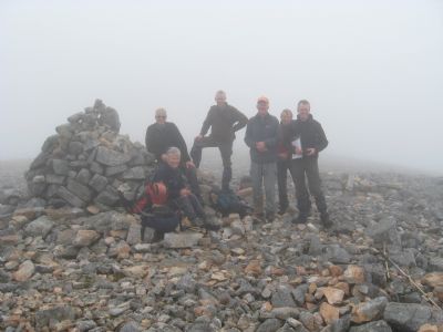
Arkle. 5/8/2012 This was a 7.00 am start because of the distance we had to travel and the length of the walk. Five of us motored down the A9, turning off for Lairg and then heading up the A838 to Loch Stack. We met two other Waybaggers there who had travelled from the Thurso side of the County. It was a pleasant morning at ground level with some warm sunshine but the top of Arkle was wreathed in cloud. We followed the stalkers path along the shore of Loch Stack passing the cottage at Lone. We left the path after 4kms and started climbing the lower slopes to our first point Meall Aonghais. At about 480 metres in height the cloud came rolling in and reduced visibility considerably. A second group of walkers passed us to our right and disappeared into the mist. After some careful compass, gps and map reading we walked on to the second highest point of Arkle at 757 metres. From here the stony path dropped steeply downwards, levellled out for a short distance then rose steeply upwards again. It was very creepy in the thick cloud seeing the grey mass of the mountain rising into the mist. At this point we met the other group of walkers heading back. The ridge we were walking on narrowed rapidly and we had to carefully pick our way over it as there were serious drops away on both sides. We finally reached the top and after some photos and a quick cup of tea we headed back through the mist. As we walked downwards the mist gradually cleared. It was good to see blue skies and the sun again. We finally arrived back at the cars but on looking back the top of Arkle was still covered in cloud. |    |
|
 | ||